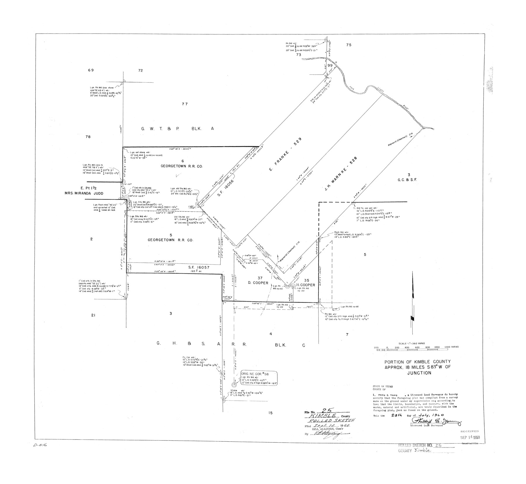
Kimble County Rolled Sketch 25
Portion of Kimble County [west of Junction]
-
Map/Doc
6515
-
Collection
General Map Collection
-
Object Dates
1960/7/28 (Creation Date)
1960/9/14 (File Date)
-
People and Organizations
Phillip G. Young (Surveyor/Engineer)
-
Counties
Kimble
-
Subjects
Surveying Rolled Sketch
-
Height x Width
26.1 x 28.3 inches
66.3 x 71.9 cm
-
Scale
1" = 360 varas
Related maps
Kimble County Sketch File 33

Print $10.00
- Digital $50.00
Kimble County Sketch File 33
1960
Size 11.2 x 8.8 inches
Map/Doc 28977
Part of: General Map Collection
Current Miscellaneous File 64

Print $12.00
- Digital $50.00
Current Miscellaneous File 64
1954
Size 10.8 x 8.5 inches
Map/Doc 74103
Jefferson County NRC Article 33.136 Sketch 4

Print $2.00
- Digital $50.00
Jefferson County NRC Article 33.136 Sketch 4
2004
Size 14.5 x 8.4 inches
Map/Doc 82993
Leon County Working Sketch 36

Print $20.00
- Digital $50.00
Leon County Working Sketch 36
1978
Size 36.1 x 32.5 inches
Map/Doc 70435
Edwards County Working Sketch 18

Print $20.00
- Digital $50.00
Edwards County Working Sketch 18
1931
Size 34.3 x 37.0 inches
Map/Doc 68894
Andrews County Sketch File 7

Print $6.00
- Digital $50.00
Andrews County Sketch File 7
1942
Size 11.2 x 8.8 inches
Map/Doc 12828
Coleman County Sketch File 30

Print $8.00
- Digital $50.00
Coleman County Sketch File 30
1875
Size 10.0 x 8.0 inches
Map/Doc 18720
Harrison County Rolled Sketch 6

Print $20.00
- Digital $50.00
Harrison County Rolled Sketch 6
1952
Size 23.8 x 24.6 inches
Map/Doc 6151
Denton County Boundary File 4 and 4a and 4b and 4c

Print $2.00
- Digital $50.00
Denton County Boundary File 4 and 4a and 4b and 4c
Size 11.0 x 8.7 inches
Map/Doc 52470
Fractional Township No. 7 South Range No. 4 West of the Indian Meridian, Indian Territory

Print $20.00
- Digital $50.00
Fractional Township No. 7 South Range No. 4 West of the Indian Meridian, Indian Territory
1898
Size 19.2 x 24.4 inches
Map/Doc 75192
Flight Mission No. DAG-23K, Frame 149, Matagorda County

Print $20.00
- Digital $50.00
Flight Mission No. DAG-23K, Frame 149, Matagorda County
1953
Size 15.9 x 15.9 inches
Map/Doc 86497
Glasscock County Sketch File 8

Print $6.00
- Digital $50.00
Glasscock County Sketch File 8
Size 9.5 x 14.9 inches
Map/Doc 24168
Travis County Sketch File 43

Print $30.00
- Digital $50.00
Travis County Sketch File 43
1887
Size 8.8 x 9.3 inches
Map/Doc 38359
You may also like
[Columbus Tap RR. Co. Block 1-A, B. S. & F. Block 1, T. & N. O. Block 7T and vicinity]
![90577, [Columbus Tap RR. Co. Block 1-A, B. S. & F. Block 1, T. & N. O. Block 7T and vicinity], Twichell Survey Records](https://historictexasmaps.com/wmedia_w700/maps/90577-1.tif.jpg)
Print $2.00
- Digital $50.00
[Columbus Tap RR. Co. Block 1-A, B. S. & F. Block 1, T. & N. O. Block 7T and vicinity]
Size 6.1 x 9.6 inches
Map/Doc 90577
[Edwards County]
![4940, [Edwards County], General Map Collection](https://historictexasmaps.com/wmedia_w700/maps/4940-1.tif.jpg)
Print $40.00
- Digital $50.00
[Edwards County]
1900
Size 48.7 x 32.7 inches
Map/Doc 4940
Blanco County Sketch File 22

Print $4.00
- Digital $50.00
Blanco County Sketch File 22
1884
Size 8.7 x 15.5 inches
Map/Doc 14604
Right of Way San Antonio and Aransas Pass Railway

Print $4.00
- Digital $50.00
Right of Way San Antonio and Aransas Pass Railway
1919
Size 11.6 x 18.5 inches
Map/Doc 62561
Fort Bend County State Real Property Sketch 12

Print $40.00
- Digital $50.00
Fort Bend County State Real Property Sketch 12
1986
Size 43.2 x 35.0 inches
Map/Doc 61686
Map of Nacogdoches County

Print $20.00
- Digital $50.00
Map of Nacogdoches County
1881
Size 24.1 x 21.5 inches
Map/Doc 4605
San Patricio County Rolled Sketch 47

Print $20.00
- Digital $50.00
San Patricio County Rolled Sketch 47
1939
Size 27.6 x 29.6 inches
Map/Doc 7731
Jack County Working Sketch 16

Print $20.00
- Digital $50.00
Jack County Working Sketch 16
1982
Size 25.7 x 25.7 inches
Map/Doc 66442

McMullen County Working Sketch 47

Print $40.00
- Digital $50.00
McMullen County Working Sketch 47
1983
Size 55.8 x 43.3 inches
Map/Doc 70748
Flight Mission No. CRC-3R, Frame 93, Chambers County

Print $20.00
- Digital $50.00
Flight Mission No. CRC-3R, Frame 93, Chambers County
1956
Size 18.5 x 22.5 inches
Map/Doc 84831
Castro County Rolled Sketch 12

Print $20.00
- Digital $50.00
Castro County Rolled Sketch 12
1945
Size 25.7 x 15.8 inches
Map/Doc 5421