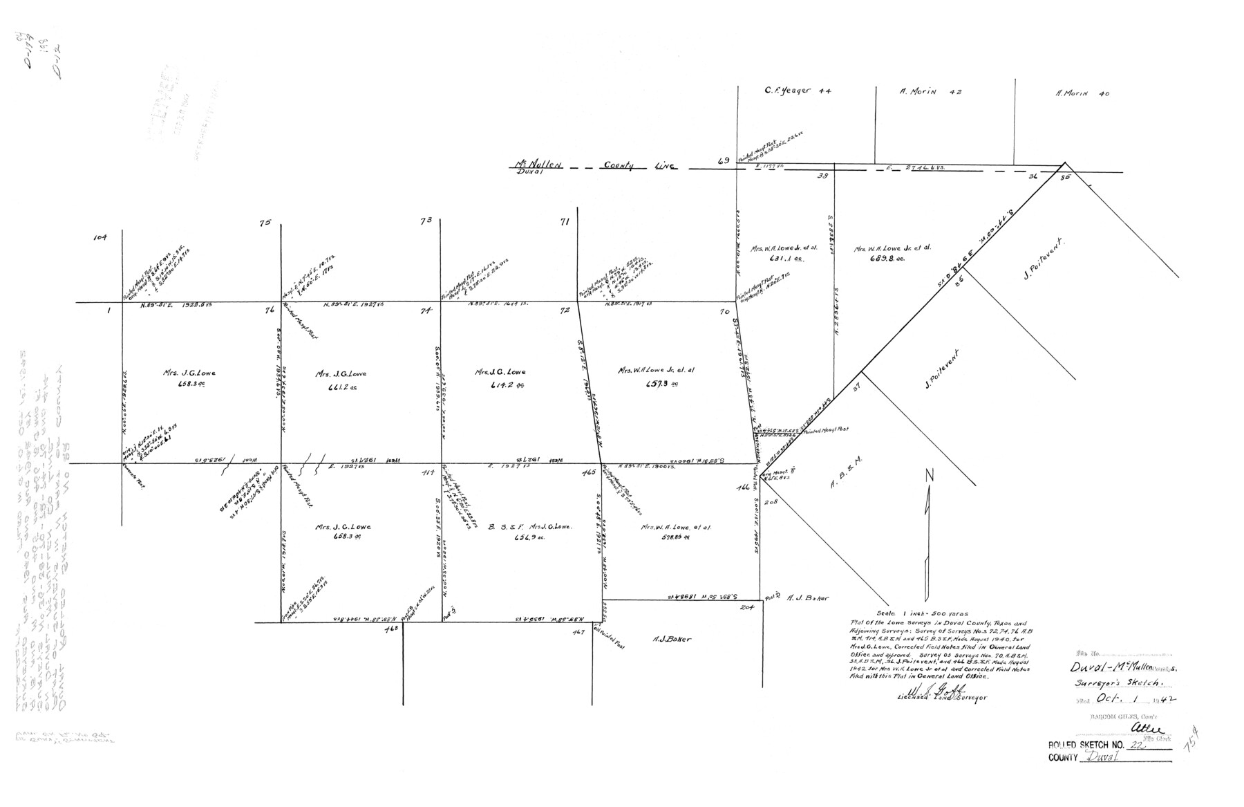
Duval County Rolled Sketch 22
Plat of the Lowe surveys in Duval County, Texas and adjoining surveys
-
Map/Doc
5741
-
Collection
General Map Collection
-
Object Dates
1942 (Creation Date)
1942/10/1 (File Date)
-
People and Organizations
W.S. Goff (Surveyor/Engineer)
-
Counties
Duval McMullen
-
Subjects
Surveying Rolled Sketch
-
Height x Width
19.5 x 30.0 inches
49.5 x 76.2 cm
-
Scale
1" = 500 varas
-
Comments
See Duval County Sketch File 64 (21438) for report.
Related maps
Duval County Sketch File 64

Print $6.00
- Digital $50.00
Duval County Sketch File 64
1942
Size 14.2 x 9.0 inches
Map/Doc 21438
Part of: General Map Collection
San Augustine County Sketch File 11

Print $4.00
San Augustine County Sketch File 11
Size 12.1 x 7.7 inches
Map/Doc 35654
Coke County Working Sketch 18

Print $20.00
- Digital $50.00
Coke County Working Sketch 18
1948
Size 47.0 x 39.6 inches
Map/Doc 68055
Polk County Working Sketch 29

Print $40.00
- Digital $50.00
Polk County Working Sketch 29
1960
Size 56.0 x 45.0 inches
Map/Doc 71645
Sabine Pass and mouth of the River Sabine

Print $20.00
- Digital $50.00
Sabine Pass and mouth of the River Sabine
1840
Size 27.0 x 18.3 inches
Map/Doc 72726
Swisher County Sketch File 7

Print $32.00
- Digital $50.00
Swisher County Sketch File 7
1904
Size 9.0 x 8.4 inches
Map/Doc 37622
Crockett County Sketch File 10 and 11

Print $8.00
- Digital $50.00
Crockett County Sketch File 10 and 11
Size 12.6 x 7.3 inches
Map/Doc 19661
Harris County Sketch File 84

Print $20.00
- Digital $50.00
Harris County Sketch File 84
1950
Size 23.1 x 35.7 inches
Map/Doc 11672
Rains County Working Sketch 2

Print $20.00
- Digital $50.00
Rains County Working Sketch 2
Size 14.0 x 12.2 inches
Map/Doc 71828
Van Zandt County Working Sketch 14

Print $20.00
- Digital $50.00
Van Zandt County Working Sketch 14
1982
Size 13.2 x 11.5 inches
Map/Doc 72264
Briscoe County

Print $20.00
- Digital $50.00
Briscoe County
1879
Size 21.7 x 19.3 inches
Map/Doc 3332
Flight Mission No. DAG-24K, Frame 133, Matagorda County

Print $20.00
- Digital $50.00
Flight Mission No. DAG-24K, Frame 133, Matagorda County
1953
Size 18.5 x 22.3 inches
Map/Doc 86551
The State of Texas vs. Chas. J. Canda, et al, T. & P. Ry. Co., No. 10351

Print $522.00
- Digital $50.00
The State of Texas vs. Chas. J. Canda, et al, T. & P. Ry. Co., No. 10351
1893
Size 10.0 x 17.0 inches
Map/Doc 3048
You may also like
Montague County

Print $20.00
- Digital $50.00
Montague County
1875
Size 24.6 x 21.1 inches
Map/Doc 3884
Flight Mission No. CRC-6R, Frame 39, Chambers County

Print $20.00
- Digital $50.00
Flight Mission No. CRC-6R, Frame 39, Chambers County
1956
Size 18.7 x 22.5 inches
Map/Doc 84972
Jackson County Working Sketch 7

Print $20.00
- Digital $50.00
Jackson County Working Sketch 7
1973
Size 35.7 x 27.1 inches
Map/Doc 66455
Montague County Sketch File 20

Print $42.00
- Digital $50.00
Montague County Sketch File 20
1923
Size 34.6 x 19.8 inches
Map/Doc 12106
Bosque County Sketch File 6

Print $4.00
- Digital $50.00
Bosque County Sketch File 6
1851
Size 12.1 x 7.6 inches
Map/Doc 14748
Block D, Capitol Syndicate Subdivision of Portions of Capitol Land Reservation Leagues Number 333, 333 1/2, 336, and 345 1/2]
![91455, Block D, Capitol Syndicate Subdivision of Portions of Capitol Land Reservation Leagues Number 333, 333 1/2, 336, and 345 1/2], Twichell Survey Records](https://historictexasmaps.com/wmedia_w700/maps/91455-1.tif.jpg)
Print $20.00
- Digital $50.00
Block D, Capitol Syndicate Subdivision of Portions of Capitol Land Reservation Leagues Number 333, 333 1/2, 336, and 345 1/2]
Size 19.3 x 28.1 inches
Map/Doc 91455
Sutton County Working Sketch Graphic Index, Sheet 1 (Sketches 1 to 24)

Print $40.00
- Digital $50.00
Sutton County Working Sketch Graphic Index, Sheet 1 (Sketches 1 to 24)
1941
Size 41.9 x 55.3 inches
Map/Doc 76705
Corpus Christi is the Sportsman's Paradise

Print $20.00
Corpus Christi is the Sportsman's Paradise
1942
Size 26.7 x 16.3 inches
Map/Doc 79324
Topographical Map of the Rio Grande, Sheet No. 8

Print $20.00
- Digital $50.00
Topographical Map of the Rio Grande, Sheet No. 8
1912
Map/Doc 89532
[Sketch showing Blocks B-11, G and M-2 and 3, L, and 47, Sections 77-102]
![91734, [Sketch showing Blocks B-11, G and M-2 and 3, L, and 47, Sections 77-102], Twichell Survey Records](https://historictexasmaps.com/wmedia_w700/maps/91734-1.tif.jpg)
Print $20.00
- Digital $50.00
[Sketch showing Blocks B-11, G and M-2 and 3, L, and 47, Sections 77-102]
Size 25.6 x 18.9 inches
Map/Doc 91734
[Surveying Sketch of L. Smith, Sidney Shepherd, Kenneth Hyman, et al in Montgomery County]
![625, [Surveying Sketch of L. Smith, Sidney Shepherd, Kenneth Hyman, et al in Montgomery County], Maddox Collection](https://historictexasmaps.com/wmedia_w700/maps/00625.tif.jpg)
Print $2.00
- Digital $50.00
[Surveying Sketch of L. Smith, Sidney Shepherd, Kenneth Hyman, et al in Montgomery County]
Size 7.3 x 10.6 inches
Map/Doc 625
Borden County Rolled Sketch 3

Print $20.00
- Digital $50.00
Borden County Rolled Sketch 3
1908
Size 29.0 x 33.6 inches
Map/Doc 5155