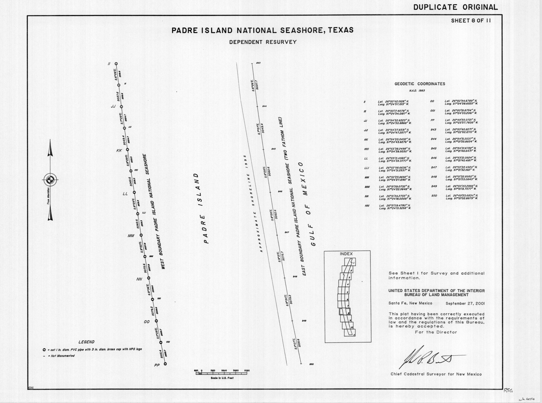
Padre Island National Seashore, Texas - Dependent Resurvey
-
Map/Doc
60550
-
Collection
General Map Collection
-
Object Dates
2001 (Creation Date)
-
Height x Width
17.9 x 24.0 inches
45.5 x 61.0 cm
Part of: General Map Collection
[Surveys in Austin's Colony near La Bahia Road]
![200, [Surveys in Austin's Colony near La Bahia Road], General Map Collection](https://historictexasmaps.com/wmedia_w700/maps/200.tif.jpg)
Print $20.00
- Digital $50.00
[Surveys in Austin's Colony near La Bahia Road]
1821
Size 10.4 x 20.2 inches
Map/Doc 200
Brazoria County NRC Article 33.136 Sketch 13

Print $42.00
- Digital $50.00
Brazoria County NRC Article 33.136 Sketch 13
2012
Size 36.0 x 23.0 inches
Map/Doc 95069
Foard County Aerial Photograph Index Sheet 4

Print $20.00
- Digital $50.00
Foard County Aerial Photograph Index Sheet 4
1950
Size 18.6 x 16.3 inches
Map/Doc 83691
Roberts County Working Sketch 20

Print $20.00
- Digital $50.00
Roberts County Working Sketch 20
1977
Size 25.6 x 32.9 inches
Map/Doc 63546
Freestone County State of Texas

Print $20.00
- Digital $50.00
Freestone County State of Texas
1888
Size 27.2 x 21.6 inches
Map/Doc 3562
Schleicher County Working Sketch 1

Print $20.00
- Digital $50.00
Schleicher County Working Sketch 1
1902
Size 14.8 x 17.4 inches
Map/Doc 63803
Travis County Working Sketch 6

Print $20.00
- Digital $50.00
Travis County Working Sketch 6
1913
Size 28.9 x 20.6 inches
Map/Doc 69390
Rusk County Rolled Sketch 8

Print $20.00
- Digital $50.00
Rusk County Rolled Sketch 8
1959
Size 22.6 x 26.3 inches
Map/Doc 7544
Flight Mission No. BRA-3M, Frame 191, Jefferson County

Print $20.00
- Digital $50.00
Flight Mission No. BRA-3M, Frame 191, Jefferson County
1953
Size 18.6 x 22.3 inches
Map/Doc 85406
Cameron County Rolled Sketch 25

Print $20.00
- Digital $50.00
Cameron County Rolled Sketch 25
1977
Size 24.8 x 36.8 inches
Map/Doc 5792
Gillespie County Rolled Sketch 2

Print $20.00
- Digital $50.00
Gillespie County Rolled Sketch 2
1977
Size 22.8 x 22.7 inches
Map/Doc 6009
Baylor County Boundary File 8

Print $2.00
- Digital $50.00
Baylor County Boundary File 8
Size 11.2 x 8.6 inches
Map/Doc 50406
You may also like
Duval County Working Sketch 40

Print $20.00
- Digital $50.00
Duval County Working Sketch 40
1960
Size 19.5 x 16.6 inches
Map/Doc 68764
Public School Land Field Note Volume Index

Public School Land Field Note Volume Index
2023
Size 8.5 x 11.0 inches
Map/Doc 97176
[Sketch around I. G. Yates S.F. 12394]
![91548, [Sketch around I. G. Yates S.F. 12394], Twichell Survey Records](https://historictexasmaps.com/wmedia_w700/maps/91548-1.tif.jpg)
Print $3.00
- Digital $50.00
[Sketch around I. G. Yates S.F. 12394]
Size 17.3 x 7.2 inches
Map/Doc 91548
Val Verde County Rolled Sketch 56

Print $20.00
- Digital $50.00
Val Verde County Rolled Sketch 56
1941
Size 39.3 x 22.8 inches
Map/Doc 8125
Cottle County Sketch File 7 1/2

Print $26.00
- Digital $50.00
Cottle County Sketch File 7 1/2
1889
Size 40.2 x 21.0 inches
Map/Doc 10342
Hopkins County Sketch File 16b

Print $7.00
- Digital $50.00
Hopkins County Sketch File 16b
1870
Size 8.1 x 12.8 inches
Map/Doc 26717
The Rand-McNally Official Railway Guide Map of the United States with portions of the Dominion of Canada, the Republic of Mexico, and the West Indies

Print $20.00
- Digital $50.00
The Rand-McNally Official Railway Guide Map of the United States with portions of the Dominion of Canada, the Republic of Mexico, and the West Indies
1927
Size 31.1 x 43.5 inches
Map/Doc 95864
Flight Mission No. DIX-5P, Frame 142, Aransas County

Print $20.00
- Digital $50.00
Flight Mission No. DIX-5P, Frame 142, Aransas County
1956
Size 18.0 x 18.0 inches
Map/Doc 83803
La Salle County Working Sketch 46

Print $20.00
- Digital $50.00
La Salle County Working Sketch 46
1981
Size 15.9 x 20.2 inches
Map/Doc 70347

Garza County Rolled Sketch 6D

Print $20.00
- Digital $50.00
Garza County Rolled Sketch 6D
1913
Size 17.4 x 16.0 inches
Map/Doc 5998
Lavaca County Working Sketch 25

Print $20.00
- Digital $50.00
Lavaca County Working Sketch 25
1986
Size 33.3 x 29.9 inches
Map/Doc 70378