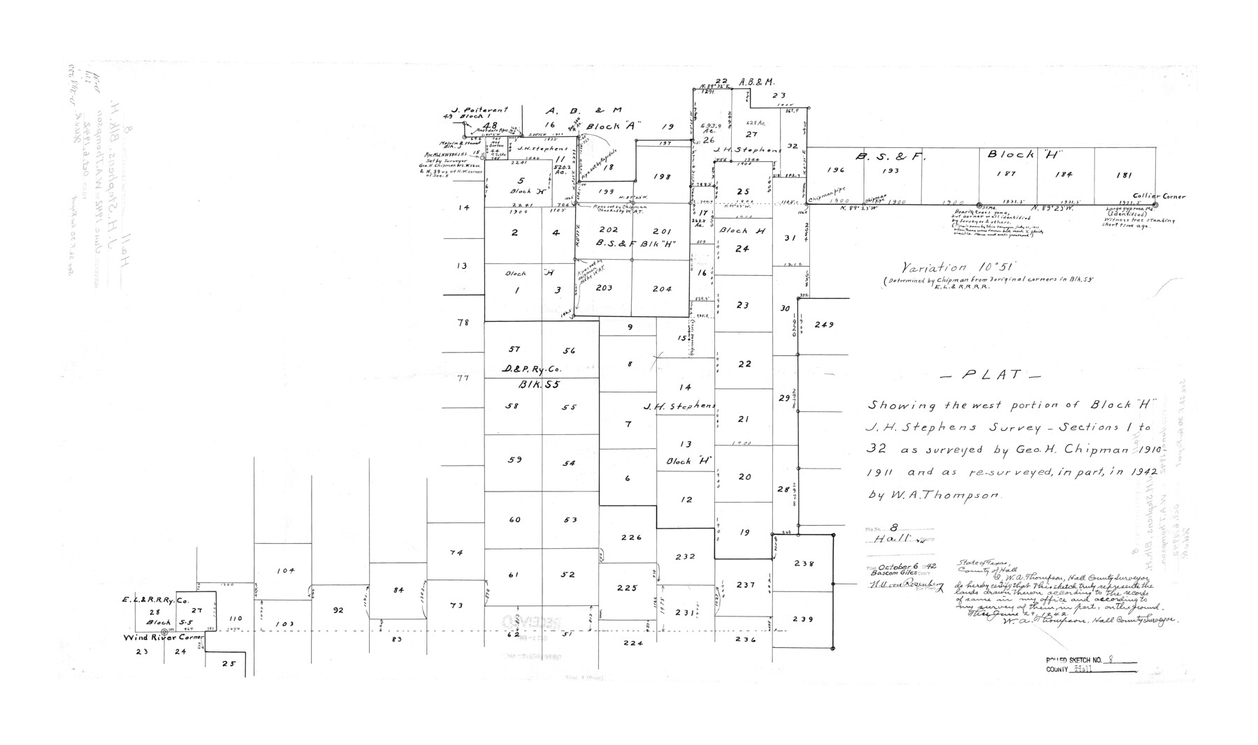
Hall County Rolled Sketch 8
Plat showing the west portion of Block H, J.H. Stephens survey - sections 1 to 32
-
Map/Doc
6052
-
Collection
General Map Collection
-
Object Dates
1942/6/29 (Creation Date)
1942/10/6 (File Date)
-
People and Organizations
W.A. Thompson (Surveyor/Engineer)
Geo. H. Chipman (Surveyor/Engineer)
-
Counties
Hall
-
Subjects
Surveying Rolled Sketch
-
Height x Width
24.7 x 41.6 inches
62.7 x 105.7 cm
-
Comments
See Hall County Sketch File 30 (24832) for report.
Related maps
Hall County Sketch File 30

Print $6.00
- Digital $50.00
Hall County Sketch File 30
1942
Size 11.3 x 8.9 inches
Map/Doc 24832
Part of: General Map Collection
Flight Mission No. DQN-1K, Frame 81, Calhoun County

Print $20.00
- Digital $50.00
Flight Mission No. DQN-1K, Frame 81, Calhoun County
1953
Size 18.4 x 22.1 inches
Map/Doc 84166
Clay County Boundary File 6

Print $2.00
- Digital $50.00
Clay County Boundary File 6
Size 8.1 x 3.5 inches
Map/Doc 51376
Orange County NRC Article 33.136 Sketch 1

Print $20.00
- Digital $50.00
Orange County NRC Article 33.136 Sketch 1
2004
Size 23.8 x 34.5 inches
Map/Doc 81979
Jack County Working Sketch 23

Print $20.00
- Digital $50.00
Jack County Working Sketch 23
2006
Size 18.4 x 22.0 inches
Map/Doc 83606
Irion County Working Sketch 9

Print $20.00
- Digital $50.00
Irion County Working Sketch 9
1941
Size 13.6 x 17.2 inches
Map/Doc 66418
Jefferson County Rolled Sketch 44

Print $20.00
- Digital $50.00
Jefferson County Rolled Sketch 44
1957
Size 26.9 x 25.5 inches
Map/Doc 6401
Orange County Sketch File 11

Print $42.00
- Digital $50.00
Orange County Sketch File 11
1876
Size 12.8 x 16.5 inches
Map/Doc 33319
Presidio County Sketch File 96

Print $4.00
- Digital $50.00
Presidio County Sketch File 96
1958
Size 9.1 x 13.4 inches
Map/Doc 34775
Terrell County Rolled Sketch 38

Print $20.00
- Digital $50.00
Terrell County Rolled Sketch 38
Size 22.7 x 18.0 inches
Map/Doc 7942
Martin County Rolled Sketch 7

Print $20.00
- Digital $50.00
Martin County Rolled Sketch 7
1929
Size 23.0 x 31.2 inches
Map/Doc 6667
Calhoun County Working Sketch 13

Print $20.00
- Digital $50.00
Calhoun County Working Sketch 13
1962
Size 28.5 x 31.9 inches
Map/Doc 67829
Sabine County

Print $20.00
- Digital $50.00
Sabine County
1920
Size 45.7 x 36.1 inches
Map/Doc 95631
You may also like
Crane County Working Sketch 27

Print $40.00
- Digital $50.00
Crane County Working Sketch 27
1972
Size 71.9 x 47.1 inches
Map/Doc 68304
Culberson County Working Sketch 76

Print $20.00
- Digital $50.00
Culberson County Working Sketch 76
1975
Size 33.4 x 43.1 inches
Map/Doc 68530
Duval County Rolled Sketch 20

Print $20.00
- Digital $50.00
Duval County Rolled Sketch 20
Size 33.2 x 42.0 inches
Map/Doc 8811
Travis County Rolled Sketch 60

Print $20.00
- Digital $50.00
Travis County Rolled Sketch 60
2014
Size 41.5 x 30.7 inches
Map/Doc 93723
Harris County Working Sketch 75

Print $20.00
- Digital $50.00
Harris County Working Sketch 75
1964
Size 29.7 x 32.3 inches
Map/Doc 65967
General Highway Map, Coleman County, Texas

Print $20.00
General Highway Map, Coleman County, Texas
1961
Size 24.6 x 18.3 inches
Map/Doc 79412
Colorado County Sketch File 30

Print $14.00
- Digital $50.00
Colorado County Sketch File 30
1943
Size 14.1 x 8.6 inches
Map/Doc 18977
Sherman County Working Sketch Graphic Index

Print $20.00
- Digital $50.00
Sherman County Working Sketch Graphic Index
1932
Size 41.5 x 36.9 inches
Map/Doc 76698
Liberty County Working Sketch 59

Print $40.00
- Digital $50.00
Liberty County Working Sketch 59
1968
Size 38.1 x 87.1 inches
Map/Doc 70519
Nueces County Sketch File 25a

Print $6.00
- Digital $50.00
Nueces County Sketch File 25a
1890
Size 14.2 x 8.4 inches
Map/Doc 32578
Goliad County Sketch File 13

Print $8.00
- Digital $50.00
Goliad County Sketch File 13
1856
Size 12.4 x 8.0 inches
Map/Doc 24239
Orange County Working Sketch 54b

Print $40.00
- Digital $50.00
Orange County Working Sketch 54b
2008
Size 38.0 x 50.3 inches
Map/Doc 88743