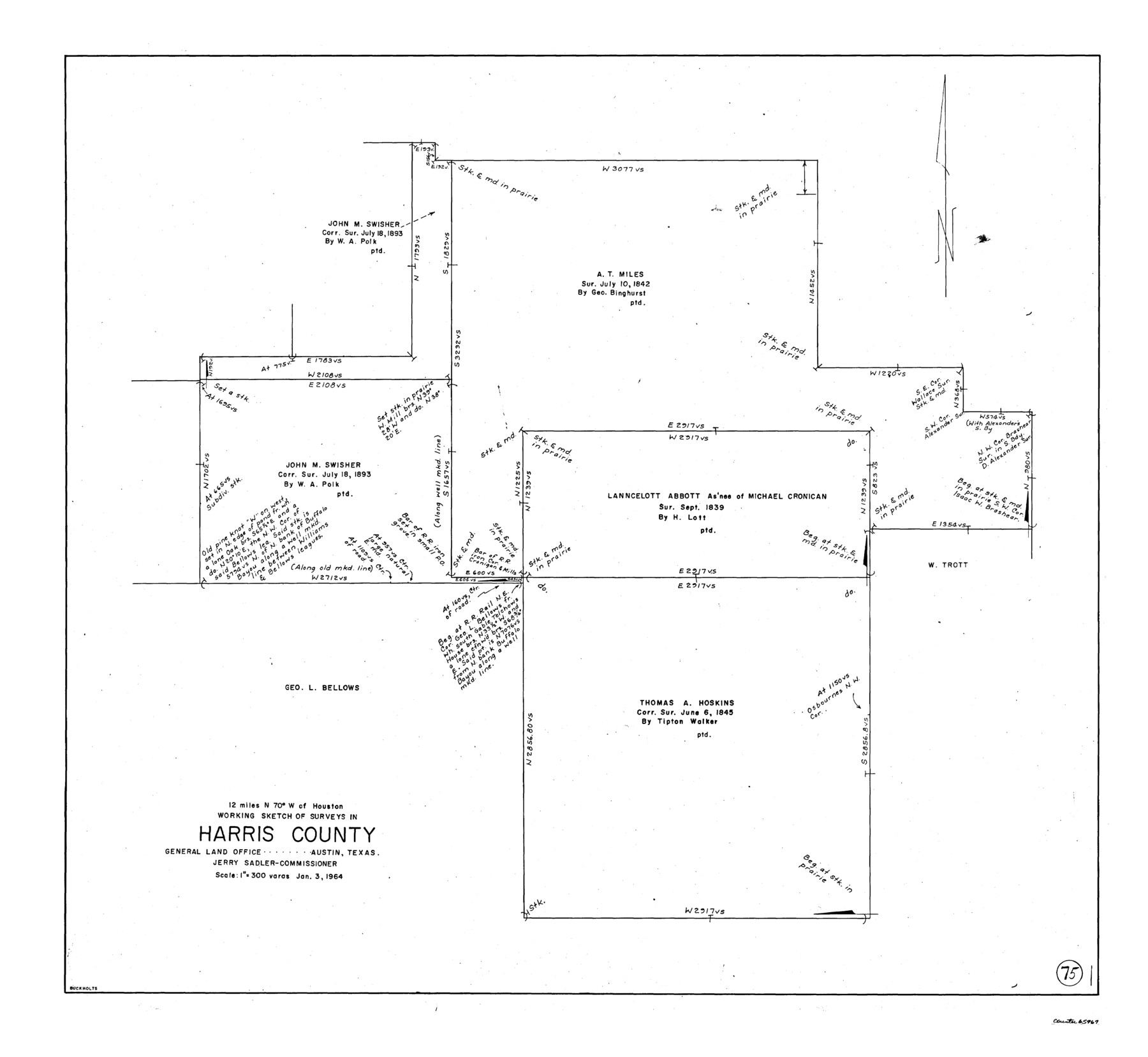
Harris County Working Sketch 75
-
Map/Doc
65967
-
Collection
General Map Collection
-
Object Dates
1/3/1964 (Creation Date)
-
People and Organizations
Roy Buckholts (Draftsman)
-
Counties
Harris
-
Subjects
Surveying Working Sketch
-
Height x Width
29.7 x 32.3 inches
75.4 x 82.0 cm
-
Scale
1" = 300 varas
Part of: General Map Collection
Map of Galveston, Turtle & East Bays & portions of the Gulf of Mexico in Chambers & Galveston Counties, Texas showing subdivision for mineral development

Print $40.00
- Digital $50.00
Map of Galveston, Turtle & East Bays & portions of the Gulf of Mexico in Chambers & Galveston Counties, Texas showing subdivision for mineral development
1945
Size 46.3 x 52.8 inches
Map/Doc 3068
Brazos River, Brazos River Sheet 8

Print $20.00
- Digital $50.00
Brazos River, Brazos River Sheet 8
1926
Size 22.2 x 27.7 inches
Map/Doc 69672
Van Zandt County Working Sketch 2

Print $20.00
- Digital $50.00
Van Zandt County Working Sketch 2
1910
Size 17.8 x 11.6 inches
Map/Doc 72251
Medina County Rolled Sketch 4

Print $20.00
- Digital $50.00
Medina County Rolled Sketch 4
1943
Size 20.2 x 26.4 inches
Map/Doc 6740
San Patricio County Working Sketch 10

Print $20.00
- Digital $50.00
San Patricio County Working Sketch 10
1939
Size 28.1 x 32.6 inches
Map/Doc 63772
Terrell County Rolled Sketch 21

Print $20.00
- Digital $50.00
Terrell County Rolled Sketch 21
Size 19.1 x 27.7 inches
Map/Doc 7929
Mills County Sketch File 1

Print $8.00
- Digital $50.00
Mills County Sketch File 1
1853
Size 11.6 x 12.7 inches
Map/Doc 31641
Waller County Sketch File 9

Print $4.00
- Digital $50.00
Waller County Sketch File 9
Size 9.1 x 7.8 inches
Map/Doc 39610
Garza County Working Sketch 6

Print $20.00
- Digital $50.00
Garza County Working Sketch 6
1944
Size 24.8 x 20.2 inches
Map/Doc 63153
Hutchinson County Sketch File 32

Print $20.00
- Digital $50.00
Hutchinson County Sketch File 32
1924
Size 16.7 x 18.0 inches
Map/Doc 11820
Tom Green County Sketch File 51

Print $20.00
- Digital $50.00
Tom Green County Sketch File 51
1884
Size 44.0 x 27.5 inches
Map/Doc 10403
Trinity County Sketch File 17

Print $4.00
- Digital $50.00
Trinity County Sketch File 17
Size 8.0 x 7.4 inches
Map/Doc 38546
You may also like
Hays County Working Sketch 11

Print $20.00
- Digital $50.00
Hays County Working Sketch 11
1950
Size 22.7 x 33.1 inches
Map/Doc 66085
Callahan County Working Sketch Graphic Index

Print $20.00
- Digital $50.00
Callahan County Working Sketch Graphic Index
1969
Size 41.3 x 33.4 inches
Map/Doc 76485
Lamar County State Real Property Sketch 1

Print $40.00
- Digital $50.00
Lamar County State Real Property Sketch 1
2013
Size 48.0 x 36.0 inches
Map/Doc 93662
Crane County Working Sketch 8

Print $20.00
- Digital $50.00
Crane County Working Sketch 8
1929
Size 33.2 x 28.4 inches
Map/Doc 68285
Deaf Smith County, Texas / [Sec. 144, Blk. K-5]
![92037, Deaf Smith County, Texas / [Sec. 144, Blk. K-5], Twichell Survey Records](https://historictexasmaps.com/wmedia_w700/maps/92037-1.tif.jpg)
Print $20.00
- Digital $50.00
Deaf Smith County, Texas / [Sec. 144, Blk. K-5]
Size 25.6 x 19.6 inches
Map/Doc 92037
Flight Mission No. DQN-5K, Frame 143, Calhoun County

Print $20.00
- Digital $50.00
Flight Mission No. DQN-5K, Frame 143, Calhoun County
1953
Size 18.8 x 22.3 inches
Map/Doc 84418
Hansford County, Texas

Print $20.00
- Digital $50.00
Hansford County, Texas
1880
Size 21.4 x 18.0 inches
Map/Doc 519
Collin County Working Sketch 6

Print $20.00
- Digital $50.00
Collin County Working Sketch 6
1996
Size 11.2 x 42.2 inches
Map/Doc 68100
Harris County Working Sketch 78

Print $20.00
- Digital $50.00
Harris County Working Sketch 78
1968
Size 32.8 x 25.8 inches
Map/Doc 65970
Polk County Working Sketch 20

Print $40.00
- Digital $50.00
Polk County Working Sketch 20
1952
Size 42.2 x 51.7 inches
Map/Doc 71635
Zavala County Sketch File 46

Print $20.00
- Digital $50.00
Zavala County Sketch File 46
1937
Size 16.7 x 18.8 inches
Map/Doc 12734
Hutchinson County Sketch File 43

Print $4.00
- Digital $50.00
Hutchinson County Sketch File 43
1891
Size 11.2 x 8.8 inches
Map/Doc 27309