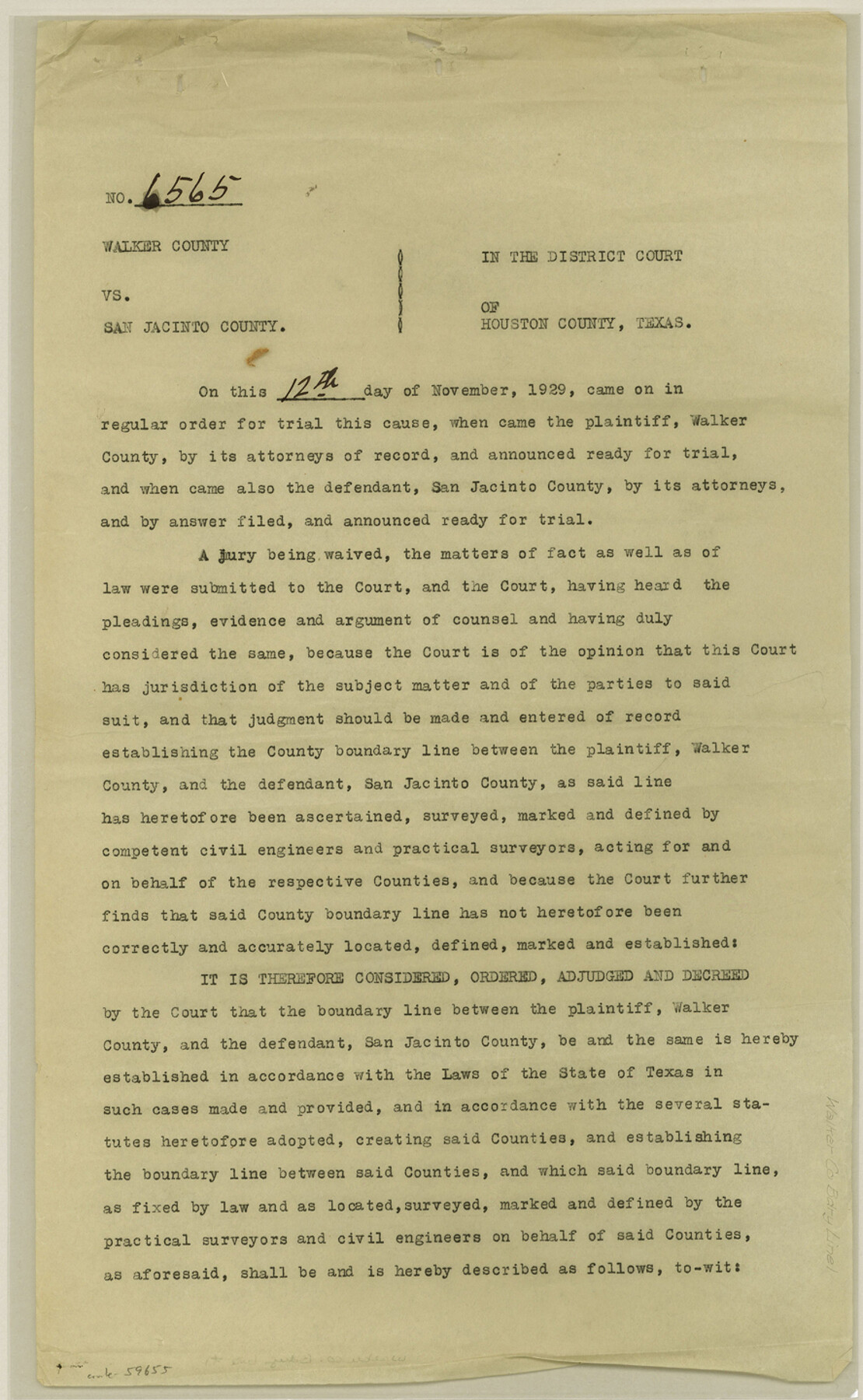
Walker County Boundary File 1
Walker-San Jacinto County Line Judgment of Court Plat and Field Notes
-
Map/Doc
59655
-
Collection
General Map Collection
-
Counties
Walker
-
Subjects
County Boundaries
-
Height x Width
14.4 x 8.9 inches
36.6 x 22.6 cm
Part of: General Map Collection


[Map of Upshur County]
![[Map of Upshur County]](https://historictexasmaps.com/wmedia_w700/maps/4651.tif.jpg)
Print $20.00
- Digital $50.00
[Map of Upshur County]
1850
Size 25.2 x 17.8 inches
Map/Doc 4651
Culberson County Working Sketch 35

Print $20.00
- Digital $50.00
Culberson County Working Sketch 35
1963
Size 23.6 x 24.0 inches
Map/Doc 68488
Flight Mission No. DCL-6C, Frame 119, Kenedy County

Print $20.00
- Digital $50.00
Flight Mission No. DCL-6C, Frame 119, Kenedy County
1943
Size 18.6 x 22.3 inches
Map/Doc 85949
Blanco County Sketch File 30

Print $5.00
- Digital $50.00
Blanco County Sketch File 30
Size 9.1 x 10.6 inches
Map/Doc 14627
Flight Mission No. BQY-15M, Frame 13, Harris County

Print $20.00
- Digital $50.00
Flight Mission No. BQY-15M, Frame 13, Harris County
1953
Size 18.8 x 22.5 inches
Map/Doc 85311
Brown County Working Sketch 19

Print $20.00
- Digital $50.00
Brown County Working Sketch 19
1998
Size 37.1 x 34.8 inches
Map/Doc 67784
Foard County Rolled Sketch 13

Print $20.00
- Digital $50.00
Foard County Rolled Sketch 13
1958
Size 25.2 x 31.4 inches
Map/Doc 5887
Cooke County Rolled Sketch 5

Print $20.00
- Digital $50.00
Cooke County Rolled Sketch 5
1980
Size 18.2 x 24.0 inches
Map/Doc 5563
Andrews County Sketch File 1

Print $6.00
- Digital $50.00
Andrews County Sketch File 1
Size 9.0 x 13.6 inches
Map/Doc 12818
Tyler County Rolled Sketch 4

Print $20.00
- Digital $50.00
Tyler County Rolled Sketch 4
1952
Size 38.9 x 44.0 inches
Map/Doc 10028
You may also like

[Blocks 36, 37 Township 2 South]
![92320, [Blocks 36, 37 Township 2 South], Twichell Survey Records](https://historictexasmaps.com/wmedia_w700/maps/92320-1.tif.jpg)
Print $20.00
- Digital $50.00
[Blocks 36, 37 Township 2 South]
Size 24.6 x 18.9 inches
Map/Doc 92320
Stonewall County

Print $20.00
- Digital $50.00
Stonewall County
1889
Size 19.6 x 24.3 inches
Map/Doc 91883
Irion County Working Sketch 14

Print $40.00
- Digital $50.00
Irion County Working Sketch 14
1973
Size 56.3 x 30.8 inches
Map/Doc 66423
Portion of Culberson County, Texas

Print $20.00
- Digital $50.00
Portion of Culberson County, Texas
1948
Size 31.1 x 33.2 inches
Map/Doc 92609
Map and Description of Texas, containing sketches of its history, geology, geography and statistics: with concise statements, relative to the soil, climate, productions, facilities of transportation, population of the country;

Print $324.00
- Digital $50.00
Map and Description of Texas, containing sketches of its history, geology, geography and statistics: with concise statements, relative to the soil, climate, productions, facilities of transportation, population of the country;
1840
Size 6.1 x 4.1 inches
Map/Doc 93861
Kenedy County Rolled Sketch 17

Print $40.00
- Digital $50.00
Kenedy County Rolled Sketch 17
1958
Size 96.6 x 28.5 inches
Map/Doc 10726
Genl. Austins Map of Texas With Parts of the Adjoining States

Print $20.00
- Digital $50.00
Genl. Austins Map of Texas With Parts of the Adjoining States
1840
Size 28.5 x 23.4 inches
Map/Doc 2116
La Salle County Working Sketch 4

Print $20.00
- Digital $50.00
La Salle County Working Sketch 4
1915
Size 31.6 x 36.6 inches
Map/Doc 70305
Anderson County Boundary File 6

Print $9.00
- Digital $50.00
Anderson County Boundary File 6
Size 14.3 x 8.7 inches
Map/Doc 49747
Flight Mission No. CUG-3P, Frame 159, Kleberg County

Print $20.00
- Digital $50.00
Flight Mission No. CUG-3P, Frame 159, Kleberg County
1956
Size 18.7 x 22.3 inches
Map/Doc 86279
Cherokee County Working Sketch 22

Print $20.00
- Digital $50.00
Cherokee County Working Sketch 22
1972
Size 24.0 x 19.2 inches
Map/Doc 67977