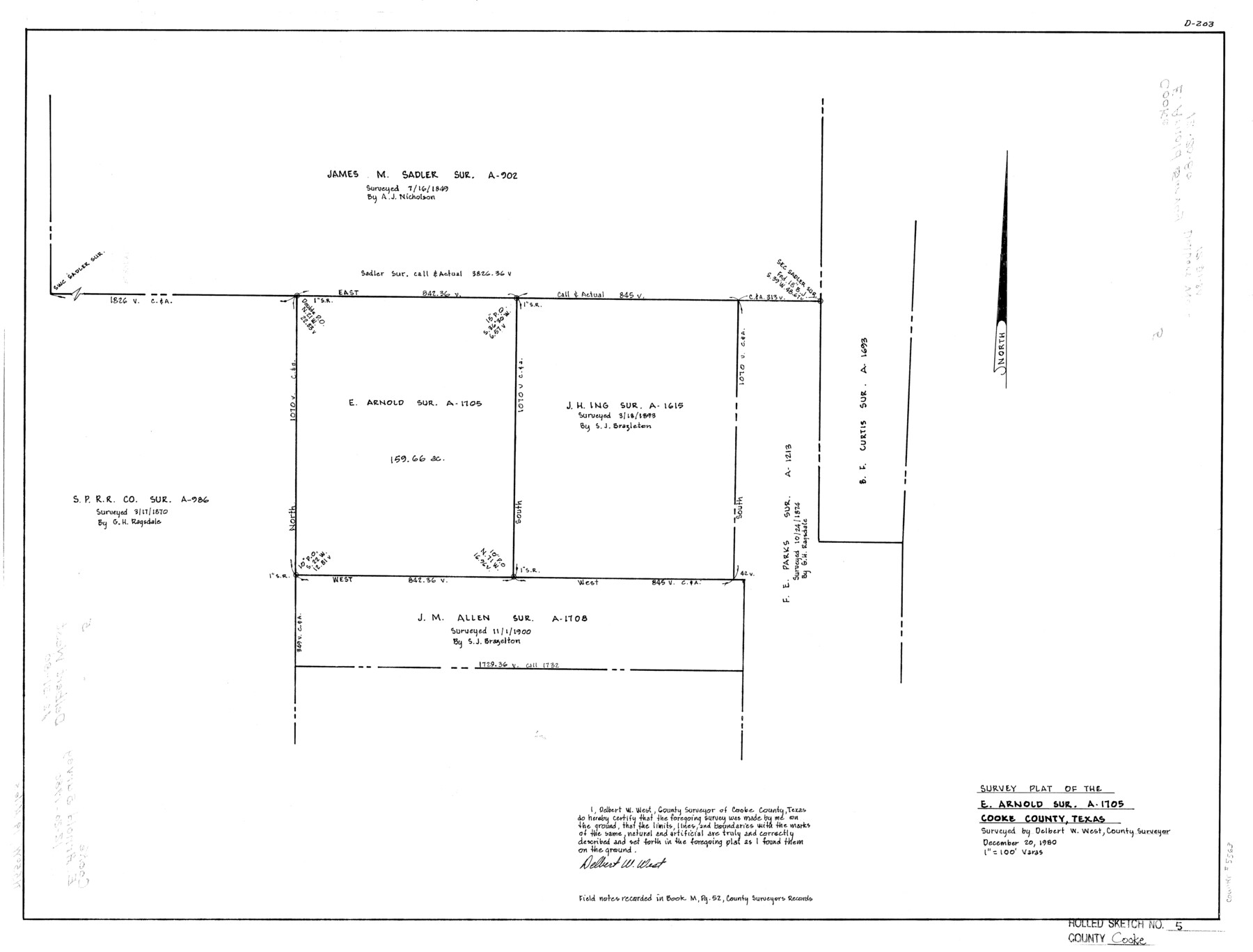
Cooke County Rolled Sketch 5
Survey plat of the E. Arnold sur. A-1705, Cooke County, Texas
-
Map/Doc
5563
-
Collection
General Map Collection
-
Object Dates
1980/12/20 (Creation Date)
1980/12/31 (File Date)
-
People and Organizations
Delbert W. West (Surveyor/Engineer)
-
Counties
Cooke
-
Subjects
Surveying Rolled Sketch
-
Height x Width
18.2 x 24.0 inches
46.2 x 61.0 cm
-
Scale
1" = 100 feet
Part of: General Map Collection
Victoria County Sketch File 2

Print $7.00
- Digital $50.00
Victoria County Sketch File 2
1873
Size 10.3 x 8.4 inches
Map/Doc 39511
Franklin County Working Sketch 3

Print $20.00
- Digital $50.00
Franklin County Working Sketch 3
1956
Size 19.5 x 16.1 inches
Map/Doc 69241
Galveston County NRC Article 33.136 Sketch 68

Print $34.00
- Digital $50.00
Galveston County NRC Article 33.136 Sketch 68
2008
Size 24.0 x 36.0 inches
Map/Doc 94840
Ward County Working Sketch 5

Print $20.00
- Digital $50.00
Ward County Working Sketch 5
1943
Size 19.1 x 36.5 inches
Map/Doc 72311
Coleman County Sketch File 24

Print $6.00
- Digital $50.00
Coleman County Sketch File 24
1872
Size 8.7 x 7.8 inches
Map/Doc 18705
Brazoria County State Real Property Sketch 2

Print $60.00
- Digital $50.00
Brazoria County State Real Property Sketch 2
2003
Size 31.0 x 42.9 inches
Map/Doc 83356
[St. Louis & Southwestern]
![64278, [St. Louis & Southwestern], General Map Collection](https://historictexasmaps.com/wmedia_w700/maps/64278.tif.jpg)
Print $20.00
- Digital $50.00
[St. Louis & Southwestern]
Size 20.8 x 28.9 inches
Map/Doc 64278
Wharton County Boundary File 1a

Print $12.00
- Digital $50.00
Wharton County Boundary File 1a
Size 11.7 x 9.2 inches
Map/Doc 59851
Loving County Rolled Sketch 11

Print $146.00
- Digital $50.00
Loving County Rolled Sketch 11
Size 10.4 x 15.5 inches
Map/Doc 46605

Texas, Brazos River, Freeport

Print $40.00
- Digital $50.00
Texas, Brazos River, Freeport
1933
Size 28.4 x 48.3 inches
Map/Doc 69994
Sectional Map No. 4 of the lands and of the lines of the Texas & Pacific R'Y. Co. in El Paso and part of Presidio Co's.

Print $20.00
- Digital $50.00
Sectional Map No. 4 of the lands and of the lines of the Texas & Pacific R'Y. Co. in El Paso and part of Presidio Co's.
1885
Size 22.3 x 17.0 inches
Map/Doc 2304
You may also like

General Highway Map, Stephens County, Texas

Print $20.00
General Highway Map, Stephens County, Texas
1961
Size 25.0 x 18.2 inches
Map/Doc 79660
Hutchinson County Rolled Sketch 41

Print $40.00
- Digital $50.00
Hutchinson County Rolled Sketch 41
1989
Size 43.3 x 144.5 inches
Map/Doc 9249
Austin County Working Sketch 4

Print $20.00
- Digital $50.00
Austin County Working Sketch 4
1959
Size 29.8 x 34.8 inches
Map/Doc 67245
Newton County Working Sketch 34

Print $20.00
- Digital $50.00
Newton County Working Sketch 34
1959
Size 27.0 x 32.6 inches
Map/Doc 71280
Galveston Entrance

Print $20.00
- Digital $50.00
Galveston Entrance
1925
Size 18.5 x 24.1 inches
Map/Doc 69859
Atascosa County Sketch File 3a

Print $6.00
- Digital $50.00
Atascosa County Sketch File 3a
1856
Size 7.1 x 8.8 inches
Map/Doc 13736
Reagan County Sketch File 16

Print $8.00
- Digital $50.00
Reagan County Sketch File 16
1932
Size 11.1 x 7.7 inches
Map/Doc 35002
Bandera County Working Sketch 13

Print $20.00
- Digital $50.00
Bandera County Working Sketch 13
1932
Size 29.1 x 25.3 inches
Map/Doc 67606
Starr County Sketch File 18

Print $20.00
- Digital $50.00
Starr County Sketch File 18
1880
Size 38.2 x 25.1 inches
Map/Doc 10606
Bandera County Working Sketch 28

Print $20.00
- Digital $50.00
Bandera County Working Sketch 28
1953
Size 24.8 x 19.5 inches
Map/Doc 67624
Motley County Sketch File 11 (N)

Print $14.00
- Digital $50.00
Motley County Sketch File 11 (N)
1900
Size 11.1 x 8.6 inches
Map/Doc 32036