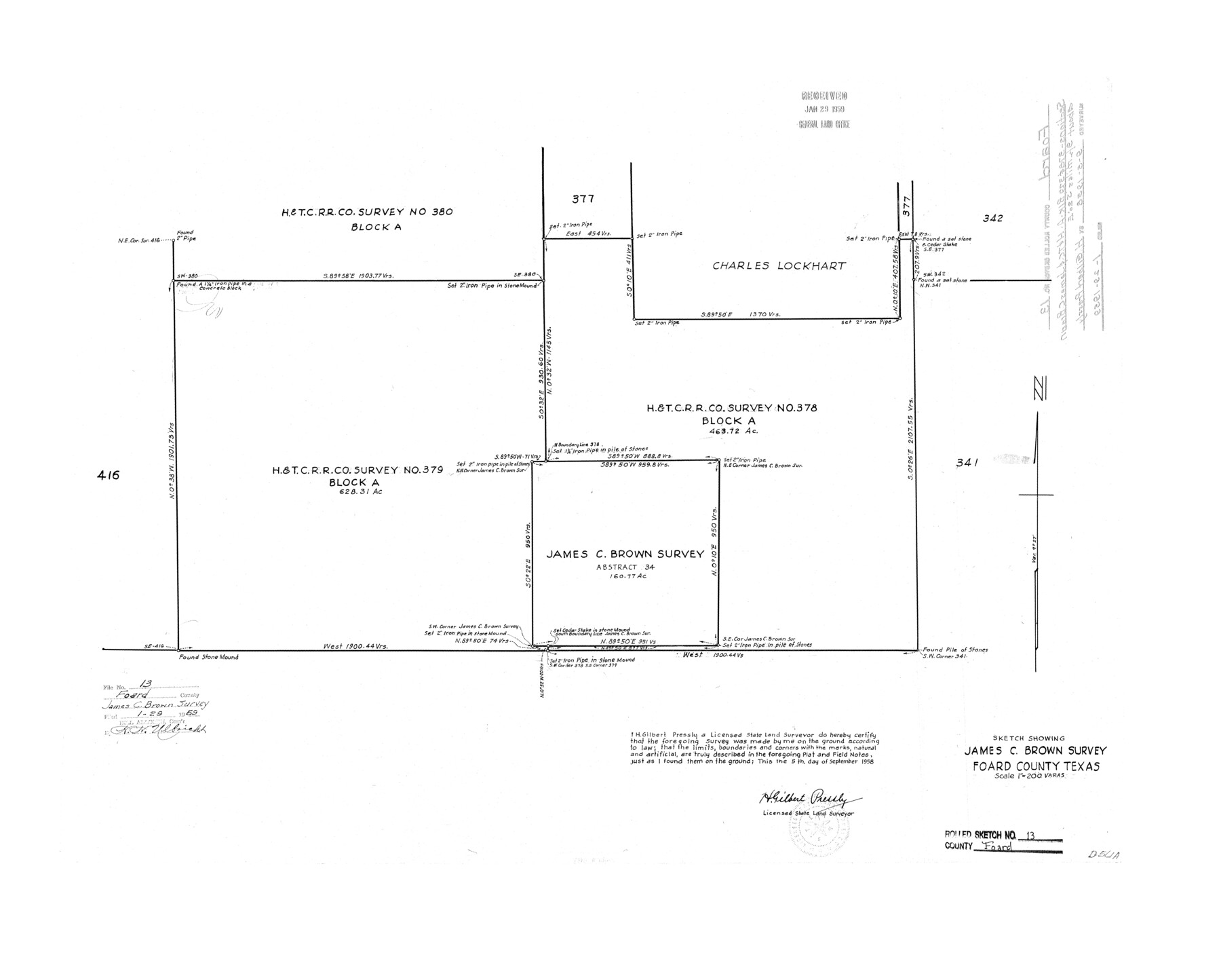
Foard County Rolled Sketch 13
Sketch showing James C. Brown survey, Foard County, Texas
-
Map/Doc
5887
-
Collection
General Map Collection
-
Object Dates
1958/9/5 (Creation Date)
1959/1/29 (File Date)
-
People and Organizations
H. Gilbert Pressly (Surveyor/Engineer)
-
Counties
Foard
-
Subjects
Surveying Rolled Sketch
-
Height x Width
25.2 x 31.4 inches
64.0 x 79.8 cm
-
Scale
1" = 200 varas
Part of: General Map Collection
Gray County Boundary File 1

Print $10.00
- Digital $50.00
Gray County Boundary File 1
Size 11.4 x 8.8 inches
Map/Doc 53845
Glasscock County Rolled Sketch 8

Print $20.00
- Digital $50.00
Glasscock County Rolled Sketch 8
1951
Size 38.4 x 32.3 inches
Map/Doc 9056
Map of Nueces County

Print $20.00
- Digital $50.00
Map of Nueces County
1875
Size 24.6 x 37.4 inches
Map/Doc 3919
Lubbock County Boundary File 4

Print $4.00
- Digital $50.00
Lubbock County Boundary File 4
Size 11.2 x 8.8 inches
Map/Doc 56491
Andrews County Working Sketch 26

Print $20.00
- Digital $50.00
Andrews County Working Sketch 26
1983
Size 34.3 x 37.5 inches
Map/Doc 67072
United States - Gulf Coast - Galveston to Rio Grande

Print $20.00
- Digital $50.00
United States - Gulf Coast - Galveston to Rio Grande
1940
Size 27.4 x 18.3 inches
Map/Doc 72757
Brewster County Rolled Sketch 114

Print $20.00
- Digital $50.00
Brewster County Rolled Sketch 114
1964
Size 11.8 x 17.8 inches
Map/Doc 5289
Map of Fort Bend Co.

Print $20.00
- Digital $50.00
Map of Fort Bend Co.
1898
Size 45.1 x 41.1 inches
Map/Doc 75965
Bexar County Sketch File 43

Print $4.00
- Digital $50.00
Bexar County Sketch File 43
1882
Size 8.7 x 10.2 inches
Map/Doc 14522
Hemphill County Sketch File 6a

Print $10.00
- Digital $50.00
Hemphill County Sketch File 6a
1903
Size 9.2 x 6.1 inches
Map/Doc 26303
[Surveys between Upper Keechi Creek and the Trinity River]
![293, [Surveys between Upper Keechi Creek and the Trinity River], General Map Collection](https://historictexasmaps.com/wmedia_w700/maps/293.tif.jpg)
Print $2.00
- Digital $50.00
[Surveys between Upper Keechi Creek and the Trinity River]
Size 8.5 x 6.9 inches
Map/Doc 293
Montgomery County Working Sketch 30

Print $20.00
- Digital $50.00
Montgomery County Working Sketch 30
1946
Size 30.7 x 34.8 inches
Map/Doc 71137
You may also like
Cherokee County Boundary File 1

Print $34.00
- Digital $50.00
Cherokee County Boundary File 1
Size 14.2 x 8.7 inches
Map/Doc 51272
Uvalde County

Print $20.00
- Digital $50.00
Uvalde County
1915
Size 43.4 x 46.4 inches
Map/Doc 63092
Calhoun County Working Sketch 8

Print $20.00
- Digital $50.00
Calhoun County Working Sketch 8
1943
Size 33.9 x 34.8 inches
Map/Doc 67824
Limestone County Sketch File 14

Print $4.00
- Digital $50.00
Limestone County Sketch File 14
1883
Size 10.7 x 8.2 inches
Map/Doc 30179
Cottle County Rolled Sketch 13

Print $20.00
- Digital $50.00
Cottle County Rolled Sketch 13
1976
Size 21.6 x 35.5 inches
Map/Doc 5571
Erath County Working Sketch 32

Print $20.00
- Digital $50.00
Erath County Working Sketch 32
1971
Size 32.0 x 25.8 inches
Map/Doc 69113
Flight Mission No. BRE-2P, Frame 135, Nueces County

Print $20.00
- Digital $50.00
Flight Mission No. BRE-2P, Frame 135, Nueces County
1956
Size 18.5 x 22.7 inches
Map/Doc 86808
San Jacinto County Working Sketch 32

Print $20.00
- Digital $50.00
San Jacinto County Working Sketch 32
1954
Size 24.0 x 24.7 inches
Map/Doc 63745
Jim Hogg County Working Sketch 7

Print $20.00
- Digital $50.00
Jim Hogg County Working Sketch 7
1964
Size 20.0 x 18.6 inches
Map/Doc 66593
Leon County Sketch File 27

Print $20.00
- Digital $50.00
Leon County Sketch File 27
1948
Size 11.2 x 8.8 inches
Map/Doc 29811
Stephens County Sketch File 7

Print $4.00
- Digital $50.00
Stephens County Sketch File 7
1875
Size 8.1 x 9.9 inches
Map/Doc 37025
Cottle County Working Sketch 24

Print $20.00
- Digital $50.00
Cottle County Working Sketch 24
2014
Size 10.6 x 18.3 inches
Map/Doc 93707