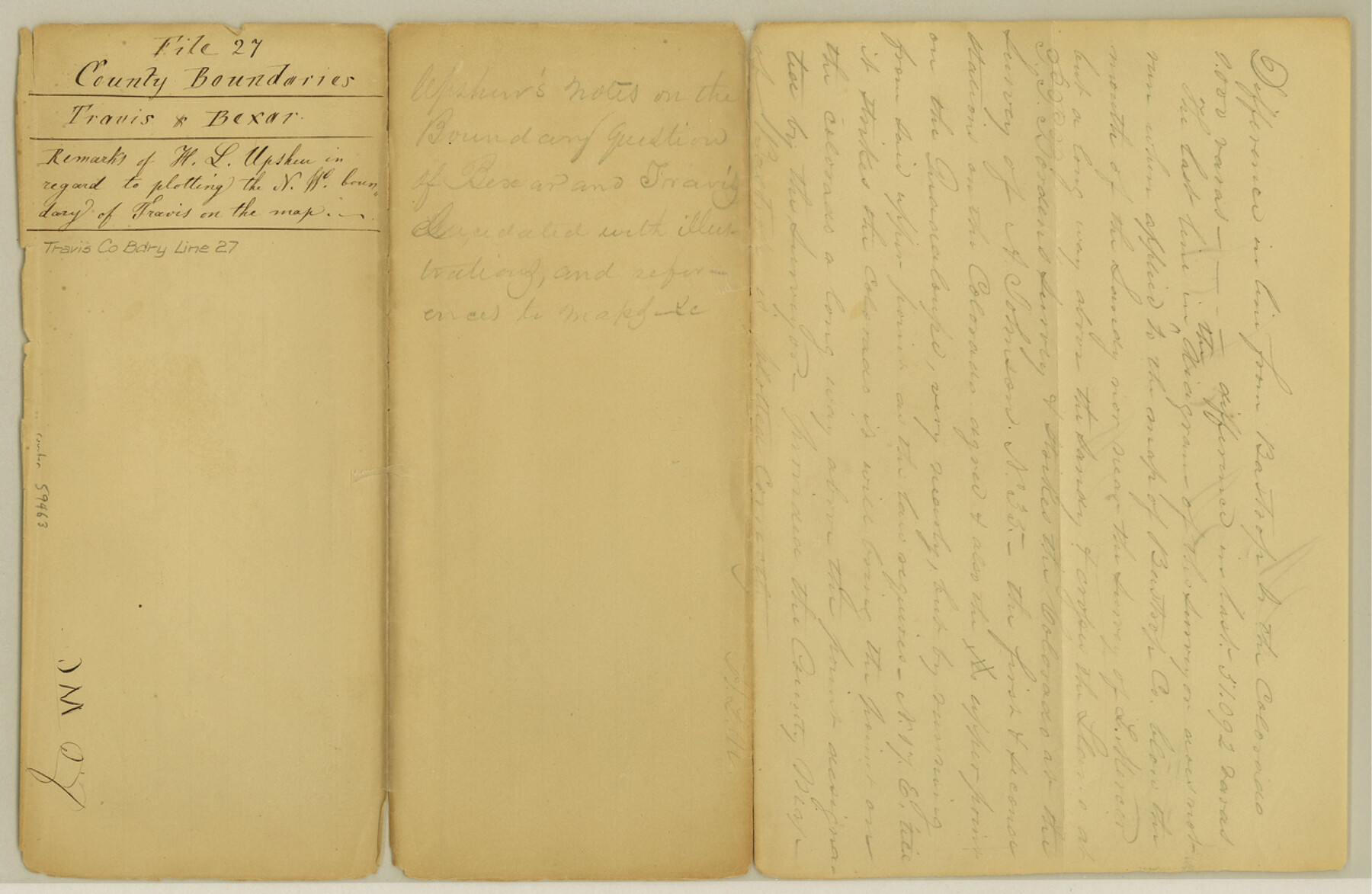
Travis County Boundary File 27
Travis & Bexar Remarks of W. L. Upshur in regard to plotting the N. W. boundary of Travis on the map
-
Map/Doc
59463
-
Collection
General Map Collection
-
Counties
Travis
-
Subjects
County Boundaries
-
Height x Width
8.4 x 12.9 inches
21.3 x 32.8 cm
Part of: General Map Collection
Wharton County

Print $40.00
- Digital $50.00
Wharton County
1946
Size 43.0 x 49.2 inches
Map/Doc 73321
Culberson County Rolled Sketch 40

Print $20.00
- Digital $50.00
Culberson County Rolled Sketch 40
Size 32.1 x 25.0 inches
Map/Doc 8751
Starr County Sketch File 28

Print $12.00
- Digital $50.00
Starr County Sketch File 28
1933
Size 11.2 x 8.8 inches
Map/Doc 36948
Map of Panola County

Print $20.00
- Digital $50.00
Map of Panola County
1897
Size 42.8 x 39.6 inches
Map/Doc 66968
Harris County State Real Property Sketch 4

Print $20.00
- Digital $50.00
Harris County State Real Property Sketch 4
2004
Size 24.4 x 36.0 inches
Map/Doc 82445
Lampasas County Working Sketch 24

Print $20.00
- Digital $50.00
Lampasas County Working Sketch 24
Size 14.3 x 13.3 inches
Map/Doc 61796
Hardin County Sketch File 37

Print $20.00
- Digital $50.00
Hardin County Sketch File 37
Size 20.4 x 17.7 inches
Map/Doc 11633

San Jacinto County Sketch File 18

Print $20.00
San Jacinto County Sketch File 18
1934
Size 43.6 x 18.1 inches
Map/Doc 10599
Goliad County Sketch File 41a

Print $4.00
- Digital $50.00
Goliad County Sketch File 41a
1958
Size 11.3 x 8.8 inches
Map/Doc 24347
Schleicher County Working Sketch 27

Print $20.00
- Digital $50.00
Schleicher County Working Sketch 27
1974
Size 26.2 x 31.8 inches
Map/Doc 63829
Hardeman County Rolled Sketch 19

Print $52.00
- Digital $50.00
Hardeman County Rolled Sketch 19
1927
Size 30.9 x 31.5 inches
Map/Doc 9109
You may also like
[Sketch showing G. & M. Blocks 5 and M-19 and B. S. & F. Block 9]
![91718, [Sketch showing G. & M. Blocks 5 and M-19 and B. S. & F. Block 9], Twichell Survey Records](https://historictexasmaps.com/wmedia_w700/maps/91718-1.tif.jpg)
Print $20.00
- Digital $50.00
[Sketch showing G. & M. Blocks 5 and M-19 and B. S. & F. Block 9]
Size 22.9 x 17.4 inches
Map/Doc 91718
Falls County Sketch File 25

Print $7.00
- Digital $50.00
Falls County Sketch File 25
1968
Size 10.4 x 8.2 inches
Map/Doc 22430
Flight Mission No. CRK-8P, Frame 115, Refugio County

Print $20.00
- Digital $50.00
Flight Mission No. CRK-8P, Frame 115, Refugio County
1956
Size 18.3 x 22.1 inches
Map/Doc 86970
[Map of Block 97, Borden and Scurry Co (Exhibit A); Map of Southeastern part of Young Territory; Map of part of of Borden, Fisher, Kent, Mitchell, Scurry and Garza Cos. Showing the north boundary line of the T&P 80 mile reservation]
![65692, [Map of Block 97, Borden and Scurry Co (Exhibit A); Map of Southeastern part of Young Territory; Map of part of of Borden, Fisher, Kent, Mitchell, Scurry and Garza Cos. Showing the north boundary line of the T&P 80 mile reservation], General Map Collection](https://historictexasmaps.com/wmedia_w700/maps/65692-1.tif.jpg)
Print $20.00
- Digital $50.00
[Map of Block 97, Borden and Scurry Co (Exhibit A); Map of Southeastern part of Young Territory; Map of part of of Borden, Fisher, Kent, Mitchell, Scurry and Garza Cos. Showing the north boundary line of the T&P 80 mile reservation]
1873
Size 33.4 x 29.6 inches
Map/Doc 65692
[Surveys in the Travis District along the Colorado River]
![115, [Surveys in the Travis District along the Colorado River], General Map Collection](https://historictexasmaps.com/wmedia_w700/maps/115.tif.jpg)
Print $2.00
- Digital $50.00
[Surveys in the Travis District along the Colorado River]
1840
Size 8.0 x 10.2 inches
Map/Doc 115
Live Oak County Sketch File 18

Print $11.00
- Digital $50.00
Live Oak County Sketch File 18
1895
Size 10.5 x 17.0 inches
Map/Doc 30284
Map of Webb County

Print $20.00
- Digital $50.00
Map of Webb County
1879
Size 36.8 x 25.4 inches
Map/Doc 4131
[Jack County School Land, Limestone County School Land and surveys in vicinity]
![90433, [Jack County School Land, Limestone County School Land and surveys in vicinity], Twichell Survey Records](https://historictexasmaps.com/wmedia_w700/maps/90433-1.tif.jpg)
Print $3.00
- Digital $50.00
[Jack County School Land, Limestone County School Land and surveys in vicinity]
1892
Size 10.2 x 15.1 inches
Map/Doc 90433
Sutton County Rolled Sketch 43

Print $20.00
- Digital $50.00
Sutton County Rolled Sketch 43
1939
Size 18.7 x 26.8 inches
Map/Doc 7885
Liles City, Gaines County, Texas

Print $20.00
- Digital $50.00
Liles City, Gaines County, Texas
Size 21.5 x 23.9 inches
Map/Doc 92683
Presidio County Working Sketch 142

Print $20.00
- Digital $50.00
Presidio County Working Sketch 142
1990
Size 24.5 x 21.7 inches
Map/Doc 71820
Packery Channel

Print $20.00
- Digital $50.00
Packery Channel
1958
Size 21.1 x 24.3 inches
Map/Doc 3007