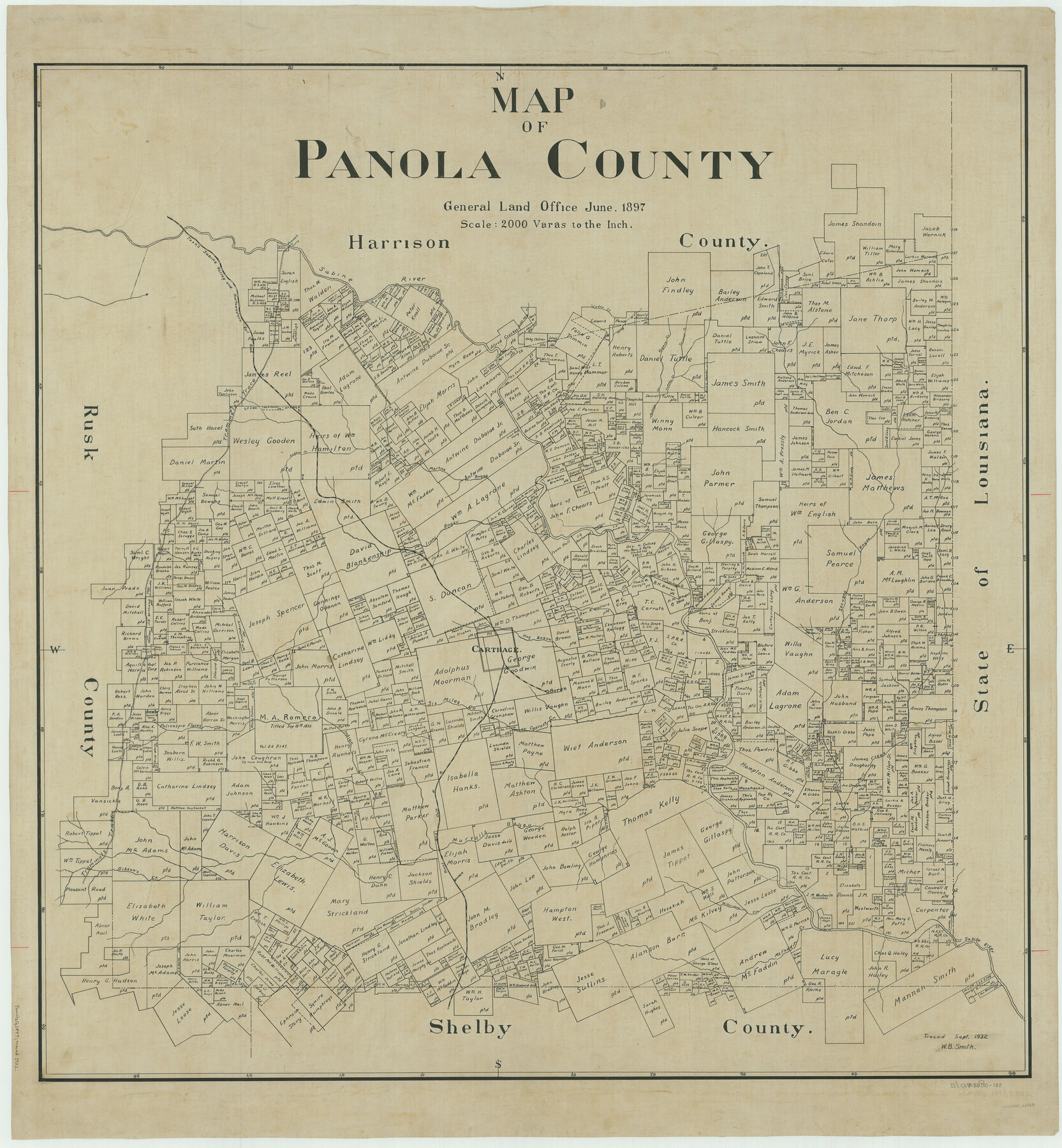
Map of Panola County
-
Map/Doc
66968
-
Collection
General Map Collection
-
Object Dates
1897 (Creation Date)
-
People and Organizations
Texas General Land Office (Publisher)
-
Counties
Panola
-
Subjects
County
-
Height x Width
42.8 x 39.6 inches
108.7 x 100.6 cm
-
Comments
Traced in September 1932 by W. B. Smith.
Part of: General Map Collection
Travis County Rolled Sketch 22

Print $20.00
- Digital $50.00
Travis County Rolled Sketch 22
1937
Size 23.4 x 26.1 inches
Map/Doc 8023
Corpus Christi Bay

Print $20.00
- Digital $50.00
Corpus Christi Bay
1975
Size 36.1 x 47.5 inches
Map/Doc 73475
Flight Mission No. BRA-6M, Frame 142, Jefferson County

Print $20.00
- Digital $50.00
Flight Mission No. BRA-6M, Frame 142, Jefferson County
1953
Size 18.6 x 22.3 inches
Map/Doc 85443

Winkler County Rolled Sketch 12

Print $20.00
- Digital $50.00
Winkler County Rolled Sketch 12
1965
Size 24.9 x 18.5 inches
Map/Doc 8279
Ward County Rolled Sketch 24C

Print $40.00
- Digital $50.00
Ward County Rolled Sketch 24C
1967
Size 54.8 x 24.4 inches
Map/Doc 10114
Flight Mission No. BRA-7M, Frame 34, Jefferson County

Print $20.00
- Digital $50.00
Flight Mission No. BRA-7M, Frame 34, Jefferson County
1953
Size 18.6 x 22.3 inches
Map/Doc 85485
Nacogdoches County Working Sketch Graphic Index

Print $20.00
- Digital $50.00
Nacogdoches County Working Sketch Graphic Index
1950
Size 46.9 x 41.3 inches
Map/Doc 76651
Atascosa County Sketch File 7

Print $4.00
- Digital $50.00
Atascosa County Sketch File 7
Size 8.2 x 6.5 inches
Map/Doc 13756
Wise County Sketch File 27

Print $4.00
- Digital $50.00
Wise County Sketch File 27
1857
Size 12.4 x 8.2 inches
Map/Doc 40576
Flight Mission No. CRC-4R, Frame 66, Chambers County

Print $20.00
- Digital $50.00
Flight Mission No. CRC-4R, Frame 66, Chambers County
1956
Size 18.6 x 22.5 inches
Map/Doc 84870
Duval County Sketch File 8a

Print $4.00
- Digital $50.00
Duval County Sketch File 8a
1875
Size 10.9 x 8.8 inches
Map/Doc 21298
You may also like
Runnels County Rolled Sketch 36

Print $40.00
- Digital $50.00
Runnels County Rolled Sketch 36
Size 61.2 x 43.0 inches
Map/Doc 76027
[San Antonio del Encinal Survey and Surveys West Thereof, Brooks County, Texas]
![10773, [San Antonio del Encinal Survey and Surveys West Thereof, Brooks County, Texas], Maddox Collection](https://historictexasmaps.com/wmedia_w700/maps/10773.tif.jpg)
Print $20.00
- Digital $50.00
[San Antonio del Encinal Survey and Surveys West Thereof, Brooks County, Texas]
Size 18.6 x 24.6 inches
Map/Doc 10773

Callahan County

Print $20.00
- Digital $50.00
Callahan County
1918
Size 45.3 x 41.0 inches
Map/Doc 66743
Bell County Sketch File 26b

Print $40.00
- Digital $50.00
Bell County Sketch File 26b
Size 14.7 x 21.1 inches
Map/Doc 10917
Harris County Boundary File 39 (12)

Print $4.00
- Digital $50.00
Harris County Boundary File 39 (12)
Size 7.7 x 8.1 inches
Map/Doc 54339
Cottle County Working Sketch 4

Print $20.00
- Digital $50.00
Cottle County Working Sketch 4
1916
Size 34.3 x 31.4 inches
Map/Doc 68314
Goliad County Sketch File 30

Print $40.00
- Digital $50.00
Goliad County Sketch File 30
Size 13.0 x 15.0 inches
Map/Doc 24327
Outer Continental Shelf Leasing Maps (Texas Offshore Operations)

Print $20.00
- Digital $50.00
Outer Continental Shelf Leasing Maps (Texas Offshore Operations)
1954
Size 20.3 x 15.5 inches
Map/Doc 75839
Houston County Working Sketch 2

Print $20.00
- Digital $50.00
Houston County Working Sketch 2
Size 16.1 x 18.6 inches
Map/Doc 66232
Tyler County Sketch File 28

Print $46.00
- Digital $50.00
Tyler County Sketch File 28
1960
Size 9.8 x 8.6 inches
Map/Doc 38699
Jack County Working Sketch 15

Print $20.00
- Digital $50.00
Jack County Working Sketch 15
1982
Size 30.6 x 25.9 inches
Map/Doc 66441