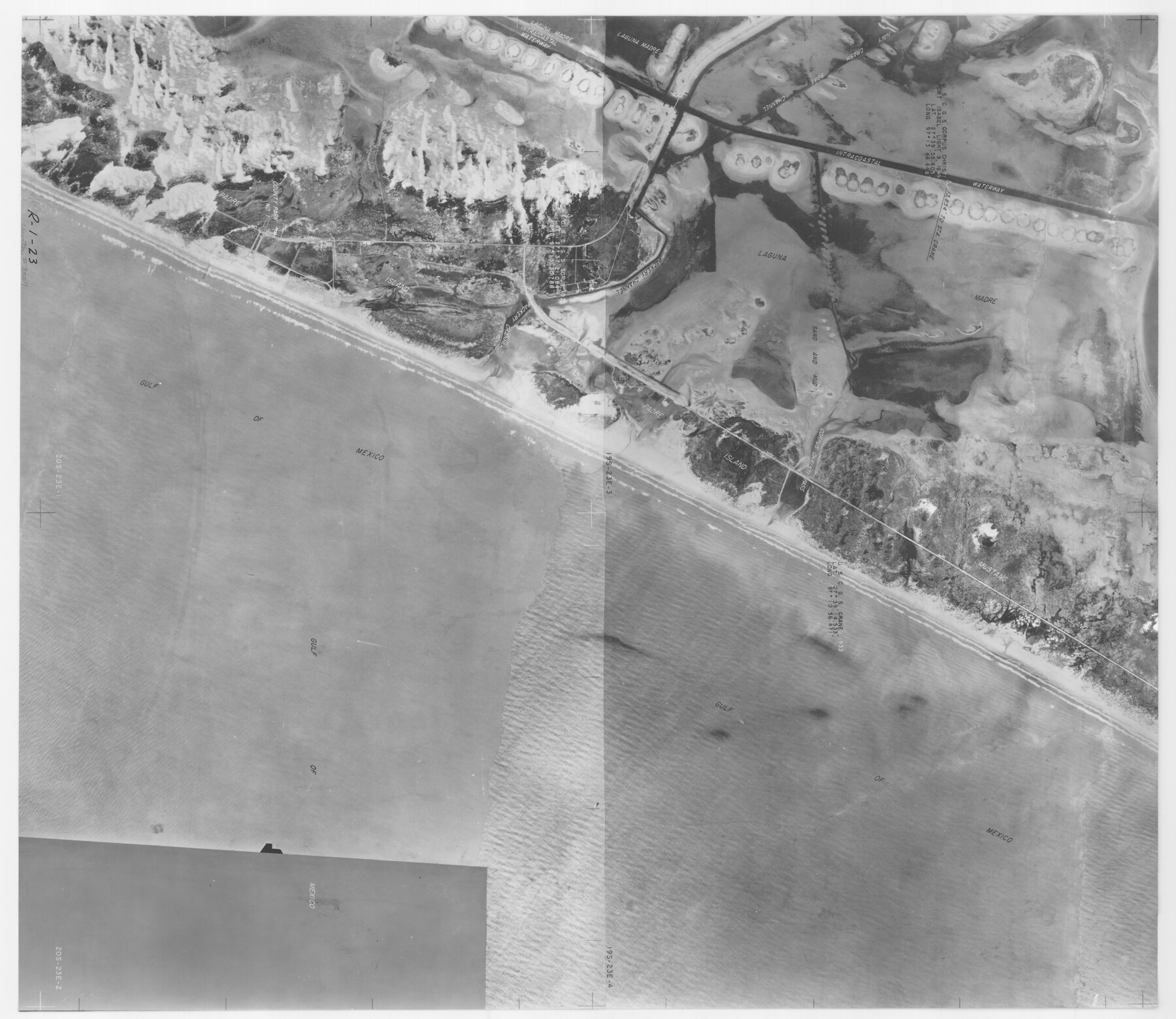
Packery Channel
-
Map/Doc
3007
-
Collection
General Map Collection
-
Object Dates
1958 (Creation Date)
-
People and Organizations
Tobin Surveys, Inc. (Author)
-
Counties
Nueces
-
Subjects
Aerial Photograph
-
Height x Width
21.1 x 24.3 inches
53.6 x 61.7 cm
-
Medium
contact print, copyrighted
-
Scale
2000 feet
-
Comments
Black and white aerial perspective mosaic of Corpus Christi Pass, Packery Channel, County Park No. 1.
Part of: General Map Collection
Hemphill County Rolled Sketch 13

Print $20.00
- Digital $50.00
Hemphill County Rolled Sketch 13
1905
Size 20.7 x 28.9 inches
Map/Doc 6193
Gregg County Sketch File 11

Print $12.00
- Digital $50.00
Gregg County Sketch File 11
1933
Size 14.4 x 8.9 inches
Map/Doc 24591
Tom Green County Working Sketch 10

Print $20.00
- Digital $50.00
Tom Green County Working Sketch 10
1959
Size 22.0 x 32.7 inches
Map/Doc 69379
Harrison County Boundary File 2

Print $40.00
- Digital $50.00
Harrison County Boundary File 2
Size 22.6 x 7.7 inches
Map/Doc 54416
Burleson County Sketch File 7

Print $40.00
- Digital $50.00
Burleson County Sketch File 7
1935
Size 17.0 x 14.5 inches
Map/Doc 16653
Burnet County Working Sketch 19

Print $20.00
- Digital $50.00
Burnet County Working Sketch 19
1982
Size 38.2 x 36.7 inches
Map/Doc 67862

Map of Surveys Made for the T&PRR in Martin & Tom Green Counties, Blocks 34-39, Reserve West of the Colorado River

Print $20.00
- Digital $50.00
Map of Surveys Made for the T&PRR in Martin & Tom Green Counties, Blocks 34-39, Reserve West of the Colorado River
1876
Size 41.9 x 43.7 inches
Map/Doc 2226
Harris County Working Sketch 44

Print $20.00
- Digital $50.00
Harris County Working Sketch 44
1941
Size 24.9 x 38.3 inches
Map/Doc 65936
Kinney County Rolled Sketch 2

Print $20.00
- Digital $50.00
Kinney County Rolled Sketch 2
Size 24.5 x 36.2 inches
Map/Doc 6534
Amistad International Reservoir on Rio Grande 68a

Print $20.00
- Digital $50.00
Amistad International Reservoir on Rio Grande 68a
1949
Size 28.4 x 39.6 inches
Map/Doc 73354
Harris County Historic Topographic 9

Print $20.00
- Digital $50.00
Harris County Historic Topographic 9
1916
Size 14.6 x 24.0 inches
Map/Doc 65819
You may also like
Brewster County Working Sketch 119

Print $20.00
- Digital $50.00
Brewster County Working Sketch 119
1909
Size 29.3 x 29.0 inches
Map/Doc 67719
Brewster County Sketch File 38

Print $4.00
- Digital $50.00
Brewster County Sketch File 38
Size 12.1 x 8.9 inches
Map/Doc 16222
Fannin County Working Sketch 10

Print $20.00
- Digital $50.00
Fannin County Working Sketch 10
1989
Size 26.5 x 38.0 inches
Map/Doc 69164
Jack County Rolled Sketch 2

Print $20.00
- Digital $50.00
Jack County Rolled Sketch 2
1972
Size 31.3 x 29.0 inches
Map/Doc 6332
Zavala County Rolled Sketch 31

Print $20.00
- Digital $50.00
Zavala County Rolled Sketch 31
1883
Size 37.4 x 27.1 inches
Map/Doc 8332
Culberson County Sketch File 2

Print $20.00
- Digital $50.00
Culberson County Sketch File 2
1882
Size 28.9 x 36.4 inches
Map/Doc 11261
[Map showing J. H. Gibson Blocks D and DD and Double Lake Corner]
![92014, [Map showing J. H. Gibson Blocks D and DD and Double Lake Corner], Twichell Survey Records](https://historictexasmaps.com/wmedia_w700/maps/92014-1.tif.jpg)
Print $20.00
- Digital $50.00
[Map showing J. H. Gibson Blocks D and DD and Double Lake Corner]
Size 31.4 x 20.4 inches
Map/Doc 92014
Polk County Sketch File 5

Print $2.00
- Digital $50.00
Polk County Sketch File 5
Size 8.0 x 7.0 inches
Map/Doc 34128
Kimble County Rolled Sketch 20

Print $20.00
- Digital $50.00
Kimble County Rolled Sketch 20
Size 14.6 x 18.1 inches
Map/Doc 6511
Robertson County Sketch File 5 1/2

Print $2.00
- Digital $50.00
Robertson County Sketch File 5 1/2
Size 8.1 x 4.2 inches
Map/Doc 35361
Lamb-Castro County Line

Print $20.00
- Digital $50.00
Lamb-Castro County Line
Size 45.2 x 14.8 inches
Map/Doc 91059
Map of Val Verde County

Print $40.00
- Digital $50.00
Map of Val Verde County
1898
Size 80.7 x 42.7 inches
Map/Doc 16913