Harris County State Real Property Sketch 4
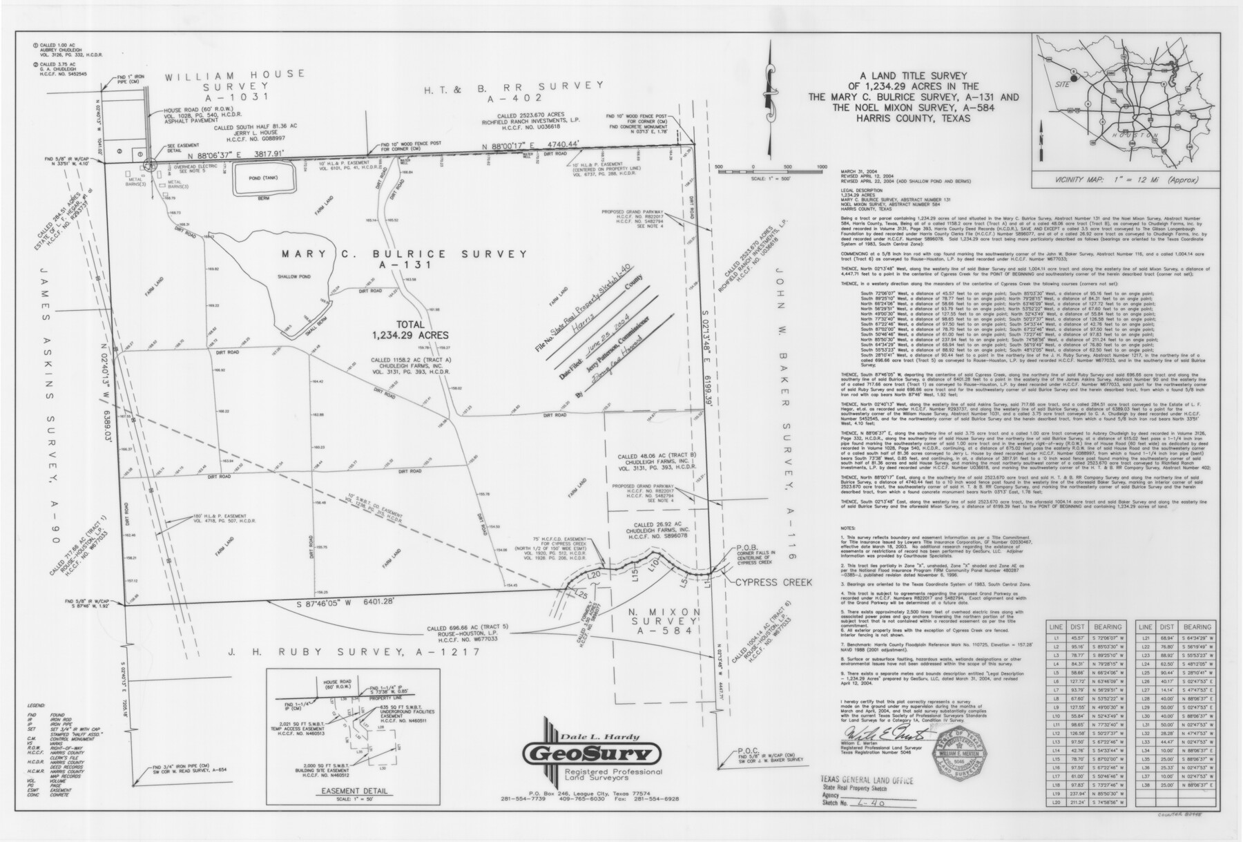
A Land Title Survey of 1,234.29 Acres in the Mary C. Bulrice (Bulriece) Survey, A - 131 and the Noel Mixon Survey, A - 584
State Real Property Sketch L - 40
-
Map/Doc
82445
-
Collection
General Map Collection
-
Object Dates
2004/4/22 (Creation Date)
-
People and Organizations
GeoSurv (Publisher)
GeoSurv (Printer)
William E. Merten (Surveyor/Engineer)
-
Counties
Harris
-
Subjects
State Real Property
-
Height x Width
24.4 x 36.0 inches
62.0 x 91.4 cm
-
Comments
Surveys located about 29 miles North 62 degrees West of Houston, Texas.
Part of: General Map Collection
Jasper County Working Sketch 23

Print $20.00
- Digital $50.00
Jasper County Working Sketch 23
1944
Size 15.9 x 22.4 inches
Map/Doc 66485
Starr County Working Sketch 4

Print $20.00
- Digital $50.00
Starr County Working Sketch 4
1927
Size 38.5 x 28.9 inches
Map/Doc 63920
Jefferson County Working Sketch 34

Print $20.00
- Digital $50.00
Jefferson County Working Sketch 34
1981
Size 33.4 x 18.8 inches
Map/Doc 66578
Hays County Rolled Sketch 24

Print $20.00
- Digital $50.00
Hays County Rolled Sketch 24
1924
Size 18.4 x 20.9 inches
Map/Doc 6180
Flight Mission No. DIX-7P, Frame 21, Aransas County

Print $20.00
- Digital $50.00
Flight Mission No. DIX-7P, Frame 21, Aransas County
1956
Size 18.8 x 22.6 inches
Map/Doc 83873
Webb County Sketch File F

Print $6.00
- Digital $50.00
Webb County Sketch File F
1900
Size 10.7 x 15.1 inches
Map/Doc 39699
Lubbock County Boundary File 11

Print $68.00
- Digital $50.00
Lubbock County Boundary File 11
Size 14.7 x 9.2 inches
Map/Doc 56583
Jasper County Working Sketch 24

Print $40.00
- Digital $50.00
Jasper County Working Sketch 24
1948
Size 46.9 x 56.2 inches
Map/Doc 66486
Flight Mission No. DCL-5C, Frame 51, Kenedy County

Print $20.00
- Digital $50.00
Flight Mission No. DCL-5C, Frame 51, Kenedy County
1943
Size 18.5 x 22.2 inches
Map/Doc 85847
La Salle County Working Sketch 56

Print $20.00
- Digital $50.00
La Salle County Working Sketch 56
2012
Size 25.5 x 23.0 inches
Map/Doc 93277
Clay County Sketch File 29

Print $16.00
- Digital $50.00
Clay County Sketch File 29
Size 11.3 x 8.7 inches
Map/Doc 18448
Railroad Track Map, H&TCRRCo., Falls County, Texas

Print $4.00
- Digital $50.00
Railroad Track Map, H&TCRRCo., Falls County, Texas
1918
Size 11.6 x 18.6 inches
Map/Doc 62848
You may also like
Randall County Sketch File 10

Print $4.00
- Digital $50.00
Randall County Sketch File 10
1941
Size 11.4 x 8.8 inches
Map/Doc 34972
Missouri, Kansas, & Texas Ry.

Print $20.00
- Digital $50.00
Missouri, Kansas, & Texas Ry.
Size 6.7 x 5.4 inches
Map/Doc 96598
Val Verde County Working Sketch 35

Print $20.00
- Digital $50.00
Val Verde County Working Sketch 35
1941
Size 31.1 x 20.7 inches
Map/Doc 72170
[Gulf Colorado & Santa Fe from 2178+36.0 to 3901+06.2]
![64699, [Gulf Colorado & Santa Fe from 2178+36.0 to 3901+06.2], General Map Collection](https://historictexasmaps.com/wmedia_w700/maps/64699.tif.jpg)
Print $40.00
- Digital $50.00
[Gulf Colorado & Santa Fe from 2178+36.0 to 3901+06.2]
Size 31.9 x 58.9 inches
Map/Doc 64699
Roberts County Sketch File 8

Print $6.00
- Digital $50.00
Roberts County Sketch File 8
1992
Size 14.3 x 8.8 inches
Map/Doc 35324
Tarrant County Sketch File 2

Print $4.00
- Digital $50.00
Tarrant County Sketch File 2
1857
Size 7.0 x 6.5 inches
Map/Doc 37674
Duval County Rolled Sketch 22

Print $20.00
- Digital $50.00
Duval County Rolled Sketch 22
1942
Size 19.5 x 30.0 inches
Map/Doc 5741
[F. W. & D. C. Ry. Co. Alignment and Right of Way Map, Clay County]
![64727, [F. W. & D. C. Ry. Co. Alignment and Right of Way Map, Clay County], General Map Collection](https://historictexasmaps.com/wmedia_w700/maps/64727-1.tif.jpg)
Print $20.00
- Digital $50.00
[F. W. & D. C. Ry. Co. Alignment and Right of Way Map, Clay County]
1927
Size 18.6 x 11.7 inches
Map/Doc 64727

[Sketch Showing Wm. T. Brewer, John R. Taylor, Wm. F. Butler, Timothy DeVore, L. M. Thorn and adjoining surveys]
![90231, [Sketch Showing Wm. T. Brewer, John R. Taylor, Wm. F. Butler, Timothy DeVore, L. M. Thorn and adjoining surveys], Twichell Survey Records](https://historictexasmaps.com/wmedia_w700/maps/90231-1.tif.jpg)
Print $20.00
- Digital $50.00
[Sketch Showing Wm. T. Brewer, John R. Taylor, Wm. F. Butler, Timothy DeVore, L. M. Thorn and adjoining surveys]
Size 27.2 x 19.4 inches
Map/Doc 90231
General Highway Map, Starr County, Texas

Print $20.00
General Highway Map, Starr County, Texas
1940
Size 24.8 x 18.5 inches
Map/Doc 79246
