Stephens County Sketch File 17
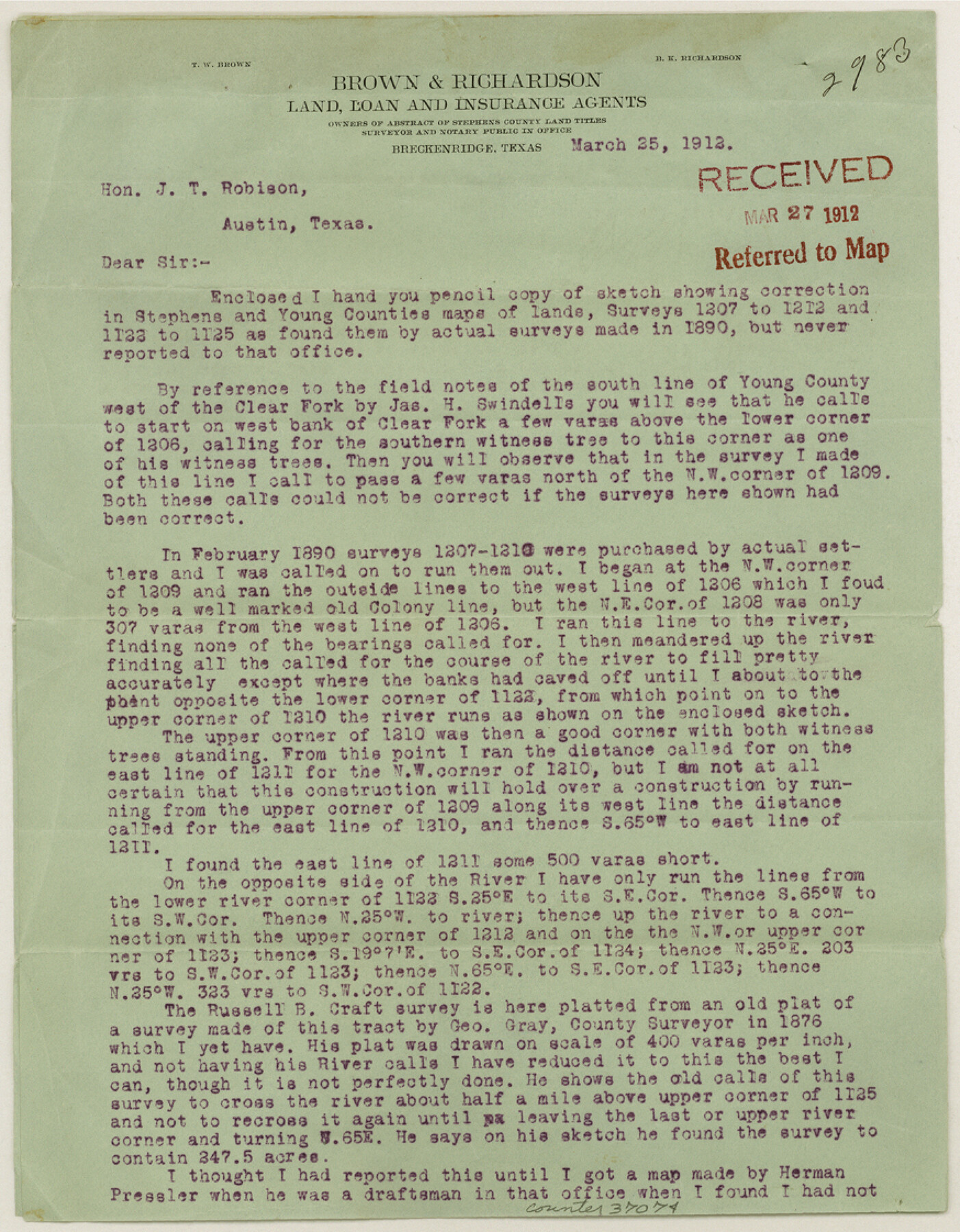
[Letter of explanation regarding corrections for T. E. & L. Co. surveys 1207-1212 and 1122-1125 in northeast part of county]
-
Map/Doc
37074
-
Collection
General Map Collection
-
Object Dates
3/25/1912 (Creation Date)
3/27/1912 (File Date)
-
People and Organizations
T.W. Brown (Surveyor/Engineer)
-
Counties
Stephens Young
-
Subjects
Surveying Sketch File
-
Height x Width
11.2 x 8.7 inches
28.5 x 22.1 cm
-
Medium
paper, print
-
Features
Clear Fork Brazos River
Part of: General Map Collection
Hudspeth County Rolled Sketch 53

Print $77.00
- Digital $50.00
Hudspeth County Rolled Sketch 53
1977
Size 9.9 x 15.1 inches
Map/Doc 45849
Jefferson County Sketch File 15b

Print $26.00
- Digital $50.00
Jefferson County Sketch File 15b
Size 17.4 x 33.2 inches
Map/Doc 11869
Nueces County Rolled Sketch 44

Print $40.00
- Digital $50.00
Nueces County Rolled Sketch 44
1948
Size 40.0 x 60.8 inches
Map/Doc 9602
Crosby County Sketch File 20

Print $20.00
- Digital $50.00
Crosby County Sketch File 20
Size 25.9 x 18.3 inches
Map/Doc 11252
Intracoastal Waterway, Houma, LA to Corpus Christi, TX

Print $5.00
- Digital $50.00
Intracoastal Waterway, Houma, LA to Corpus Christi, TX
Size 30.0 x 22.0 inches
Map/Doc 61911
Map of the United States and Texas Boundary Line and adjacent territory determined & surveyed in 1857-8-9-60 by J.H. Clark, U.S. Commissioner, &ca. &ca. under the direction of the Departement [sic] of the Interior
![94063, Map of the United States and Texas Boundary Line and adjacent territory determined & surveyed in 1857-8-9-60 by J.H. Clark, U.S. Commissioner, &ca. &ca. under the direction of the Departement [sic] of the Interior, General Map Collection](https://historictexasmaps.com/wmedia_w700/maps/94063.tif.jpg)
Print $20.00
- Digital $50.00
Map of the United States and Texas Boundary Line and adjacent territory determined & surveyed in 1857-8-9-60 by J.H. Clark, U.S. Commissioner, &ca. &ca. under the direction of the Departement [sic] of the Interior
1902
Size 27.9 x 41.8 inches
Map/Doc 94063
Angelina River, Mud Creek, Sheet 2

Print $4.00
- Digital $50.00
Angelina River, Mud Creek, Sheet 2
1937
Size 26.4 x 18.9 inches
Map/Doc 65076
Flight Mission No. DQN-2K, Frame 6, Calhoun County

Print $20.00
- Digital $50.00
Flight Mission No. DQN-2K, Frame 6, Calhoun County
1953
Size 18.4 x 22.2 inches
Map/Doc 84223
Flight Mission No. CGN-3P, Frame 141, San Patricio County

Print $20.00
- Digital $50.00
Flight Mission No. CGN-3P, Frame 141, San Patricio County
1956
Size 18.6 x 22.4 inches
Map/Doc 86985
Atascosa County Working Sketch 12

Print $20.00
- Digital $50.00
Atascosa County Working Sketch 12
1926
Size 23.0 x 29.2 inches
Map/Doc 67208
Brazoria County Working Sketch 49a

Print $20.00
- Digital $50.00
Brazoria County Working Sketch 49a
2003
Size 35.0 x 35.0 inches
Map/Doc 78347
Map of Red River Division of the International & Great Northern Railroad

Print $40.00
- Digital $50.00
Map of Red River Division of the International & Great Northern Railroad
Size 24.1 x 107.0 inches
Map/Doc 64476
You may also like
Limestone County Sketch File 17

Print $10.00
- Digital $50.00
Limestone County Sketch File 17
Size 14.4 x 8.7 inches
Map/Doc 30187
Jefferson County Working Sketch 2

Print $20.00
- Digital $50.00
Jefferson County Working Sketch 2
Size 40.0 x 29.6 inches
Map/Doc 66545
Hill County Working Sketch 4

Print $20.00
- Digital $50.00
Hill County Working Sketch 4
1982
Size 25.3 x 23.3 inches
Map/Doc 66190
Medina County Working Sketch 3

Print $40.00
- Digital $50.00
Medina County Working Sketch 3
1945
Size 52.6 x 37.1 inches
Map/Doc 70918
Webb County Sketch File 14

Print $7.00
- Digital $50.00
Webb County Sketch File 14
1877
Size 10.0 x 8.2 inches
Map/Doc 39807
Hardin County Rolled Sketch 3

Print $20.00
- Digital $50.00
Hardin County Rolled Sketch 3
1902
Size 20.1 x 17.0 inches
Map/Doc 6076
Reeves County Working Sketch 53

Print $40.00
- Digital $50.00
Reeves County Working Sketch 53
1977
Size 70.3 x 42.6 inches
Map/Doc 63496
Montgomery County Rolled Sketch 35

Print $40.00
- Digital $50.00
Montgomery County Rolled Sketch 35
Size 36.7 x 51.3 inches
Map/Doc 9543
Irion County Sketch File 18

Print $10.00
- Digital $50.00
Irion County Sketch File 18
Size 11.2 x 8.7 inches
Map/Doc 27494
Flight Mission No. BRE-1P, Frame 117, Nueces County

Print $20.00
- Digital $50.00
Flight Mission No. BRE-1P, Frame 117, Nueces County
1956
Size 18.4 x 22.3 inches
Map/Doc 86683
Limestone County Working Sketch 23

Print $20.00
- Digital $50.00
Limestone County Working Sketch 23
1980
Size 37.3 x 37.5 inches
Map/Doc 70573
Jim Hogg County Rolled Sketch 4

Print $20.00
- Digital $50.00
Jim Hogg County Rolled Sketch 4
Size 17.0 x 30.5 inches
Map/Doc 6440