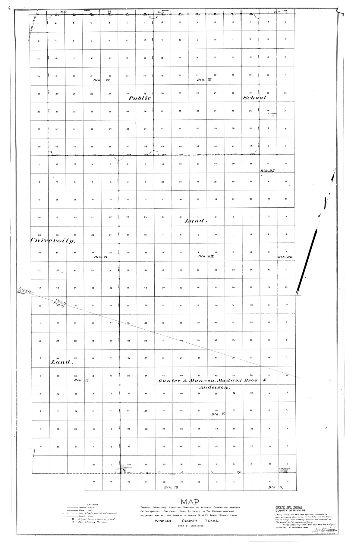
Winkler County Rolled Sketch 5
Map showing connecting lines and traverses as actually coursed and measured on the ground. The object being to locate on the ground and make fieldnotes for all the surveys in Blocks 26 & 27 Public School Land, Winkler County, Texas
-
Map/Doc
10148
-
Collection
General Map Collection
-
Object Dates
1927/4/13 (File Date)
1927/3/21 (Creation Date)
-
People and Organizations
Frank F. Friend (Surveyor/Engineer)
B.F. Kleck (Draftsman)
-
Counties
Winkler Ward
-
Subjects
Surveying Rolled Sketch
-
Height x Width
58.0 x 38.4 inches
147.3 x 97.5 cm
-
Scale
1" = 1000 varas
Part of: General Map Collection
United States - Gulf Coast - From Latitude 26° 33' to the Rio Grande Texas

Print $20.00
- Digital $50.00
United States - Gulf Coast - From Latitude 26° 33' to the Rio Grande Texas
1913
Size 27.8 x 18.4 inches
Map/Doc 72831
Rio Grande Rectification Project, El Paso and Juarez Valley

Print $20.00
- Digital $50.00
Rio Grande Rectification Project, El Paso and Juarez Valley
1935
Size 10.7 x 29.7 inches
Map/Doc 60863
Wheeler County Rolled Sketch 3

Print $20.00
- Digital $50.00
Wheeler County Rolled Sketch 3
Size 31.9 x 21.9 inches
Map/Doc 8239
Map of Shelby District

Print $20.00
- Digital $50.00
Map of Shelby District
1847
Size 17.1 x 25.4 inches
Map/Doc 4033
Upton County Working Sketch 31

Print $40.00
- Digital $50.00
Upton County Working Sketch 31
1956
Size 33.7 x 49.3 inches
Map/Doc 69527
Kleberg County Rolled Sketch 10-6

Print $20.00
- Digital $50.00
Kleberg County Rolled Sketch 10-6
1951
Size 38.0 x 39.1 inches
Map/Doc 9399
Moore County Working Sketch Graphic Index

Print $20.00
- Digital $50.00
Moore County Working Sketch Graphic Index
1932
Size 41.3 x 39.0 inches
Map/Doc 76648
Panola County Working Sketch 6

Print $20.00
- Digital $50.00
Panola County Working Sketch 6
1941
Map/Doc 71415
Denton County Sketch File C

Print $10.00
- Digital $50.00
Denton County Sketch File C
1882
Size 10.9 x 8.3 inches
Map/Doc 20682
Map of the River Sabine from its mouth on the Gulf of Mexico in the sea to Logan's Ferry in latitude 31° 58' 24" north

Print $20.00
- Digital $50.00
Map of the River Sabine from its mouth on the Gulf of Mexico in the sea to Logan's Ferry in latitude 31° 58' 24" north
1842
Size 18.3 x 9.3 inches
Map/Doc 65383
Waller County Working Sketch 6

Print $20.00
- Digital $50.00
Waller County Working Sketch 6
1988
Size 31.1 x 20.0 inches
Map/Doc 72305
Bandera County Rolled Sketch 3

Print $20.00
- Digital $50.00
Bandera County Rolled Sketch 3
1947
Size 29.3 x 35.8 inches
Map/Doc 5115
You may also like
Childress County

Print $20.00
- Digital $50.00
Childress County
1892
Size 24.7 x 19.6 inches
Map/Doc 3391
Map of the State of Texas published by the International and Gt. Northern Railroad

Print $20.00
- Digital $50.00
Map of the State of Texas published by the International and Gt. Northern Railroad
1881
Size 16.0 x 22.2 inches
Map/Doc 94092
Galveston County Sketch File 69

Print $226.00
- Digital $50.00
Galveston County Sketch File 69
1884
Size 14.4 x 9.0 inches
Map/Doc 23815
Outer Continental Shelf Leasing Maps (Louisiana Offshore Operations)

Print $20.00
- Digital $50.00
Outer Continental Shelf Leasing Maps (Louisiana Offshore Operations)
1959
Size 18.3 x 14.5 inches
Map/Doc 76112
The MKT - Texas Empire of the South

Print $20.00
- Digital $50.00
The MKT - Texas Empire of the South
1905
Size 18.6 x 40.6 inches
Map/Doc 97034
Gillespie County Rolled Sketch 8

Print $20.00
- Digital $50.00
Gillespie County Rolled Sketch 8
2008
Size 20.2 x 19.1 inches
Map/Doc 89014
Texas Railroad Map

Print $20.00
- Digital $50.00
Texas Railroad Map
1981
Size 34.8 x 35.6 inches
Map/Doc 2101
Loving County Rolled Sketch 4

Print $40.00
- Digital $50.00
Loving County Rolled Sketch 4
1952
Size 82.2 x 19.5 inches
Map/Doc 9465
General Highway Map, Burnet County, Texas

Print $20.00
General Highway Map, Burnet County, Texas
1961
Size 18.0 x 24.6 inches
Map/Doc 79392
Harrison County Sketch File 9

Print $4.00
- Digital $50.00
Harrison County Sketch File 9
1862
Size 8.3 x 11.1 inches
Map/Doc 26048
[Surveys made in Peters Colony by Thomas Leckie]
![1983, [Surveys made in Peters Colony by Thomas Leckie], General Map Collection](https://historictexasmaps.com/wmedia_w700/maps/1983.tif.jpg)
Print $20.00
- Digital $50.00
[Surveys made in Peters Colony by Thomas Leckie]
1858
Size 22.9 x 16.6 inches
Map/Doc 1983
