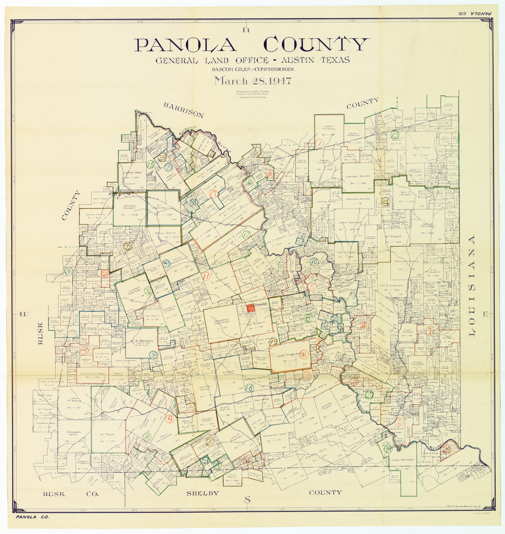
Panola County Working Sketch Graphic Index
-
Map/Doc
76660
-
Collection
General Map Collection
-
Object Dates
3/28/1947 (Creation Date)
-
People and Organizations
Curtis R. Hale (Compiler)
Tommye Buie (Draftsman)
-
Counties
Panola
-
Subjects
County Surveying Working Sketch
-
Scale
1" = 2000 varas
Part of: General Map Collection
Map of Refugio County

Print $20.00
- Digital $50.00
Map of Refugio County
1875
Size 20.9 x 28.2 inches
Map/Doc 3988
Reeves County Boundary File 81 1/2

Print $54.00
- Digital $50.00
Reeves County Boundary File 81 1/2
Size 9.7 x 8.3 inches
Map/Doc 58216
Hutchinson County Sketch File 46

Print $50.00
- Digital $50.00
Hutchinson County Sketch File 46
1981
Size 11.2 x 8.7 inches
Map/Doc 27365
Galveston County NRC Article 33.136 Location Key Sheet

Print $20.00
- Digital $50.00
Galveston County NRC Article 33.136 Location Key Sheet
1994
Size 27.0 x 23.0 inches
Map/Doc 77018
Mason County Sketch File 4

Print $6.00
- Digital $50.00
Mason County Sketch File 4
1875
Size 12.9 x 8.0 inches
Map/Doc 30684
Flight Mission No. DAG-19K, Frame 66, Matagorda County

Print $20.00
- Digital $50.00
Flight Mission No. DAG-19K, Frame 66, Matagorda County
1952
Size 16.3 x 16.3 inches
Map/Doc 86393
Newton County Boundary File 1

Print $4.00
- Digital $50.00
Newton County Boundary File 1
Size 14.3 x 8.8 inches
Map/Doc 57614
Leon County Sketch File 28

Print $8.00
- Digital $50.00
Leon County Sketch File 28
1951
Size 11.2 x 8.7 inches
Map/Doc 29821
[Plat and field notes of 3.107 acre tract for Clement Cove Harbor Company]

Print $2.00
- Digital $50.00
[Plat and field notes of 3.107 acre tract for Clement Cove Harbor Company]
1987
Size 13.7 x 8.5 inches
Map/Doc 60398
Edwards County Working Sketch 40

Print $20.00
- Digital $50.00
Edwards County Working Sketch 40
1949
Size 19.8 x 18.6 inches
Map/Doc 68916
Kerr County Sketch File 1b

Print $2.00
- Digital $50.00
Kerr County Sketch File 1b
Size 8.1 x 10.2 inches
Map/Doc 28850
Hudspeth County Working Sketch 24

Print $40.00
- Digital $50.00
Hudspeth County Working Sketch 24
1967
Size 46.0 x 54.9 inches
Map/Doc 66306
You may also like
Flight Mission No. DAG-22K, Frame 86, Matagorda County

Print $20.00
- Digital $50.00
Flight Mission No. DAG-22K, Frame 86, Matagorda County
1953
Size 15.7 x 15.5 inches
Map/Doc 86470
Flight Mission No. DAH-17M, Frame 30, Orange County

Print $20.00
- Digital $50.00
Flight Mission No. DAH-17M, Frame 30, Orange County
1953
Size 18.7 x 22.5 inches
Map/Doc 86893
Schleicher County Rolled Sketch 27

Print $20.00
- Digital $50.00
Schleicher County Rolled Sketch 27
Size 37.4 x 43.3 inches
Map/Doc 9909
Flight Mission No. CLL-1N, Frame 9, Willacy County

Print $20.00
- Digital $50.00
Flight Mission No. CLL-1N, Frame 9, Willacy County
1954
Size 18.4 x 22.1 inches
Map/Doc 86996
[Map of Texas and Indian Territory]
![93757, [Map of Texas and Indian Territory], General Map Collection](https://historictexasmaps.com/wmedia_w700/maps/93757-1.tif.jpg)
Print $20.00
- Digital $50.00
[Map of Texas and Indian Territory]
1878
Size 26.2 x 20.1 inches
Map/Doc 93757
Leon County Working Sketch 19

Print $20.00
- Digital $50.00
Leon County Working Sketch 19
1962
Size 31.2 x 31.4 inches
Map/Doc 70418
Right of Way & Track Map, St. Louis, Brownsville & Mexico Ry. operated by St. Louis, Brownsville & Mexico Ry. Co.

Print $40.00
- Digital $50.00
Right of Way & Track Map, St. Louis, Brownsville & Mexico Ry. operated by St. Louis, Brownsville & Mexico Ry. Co.
1919
Size 25.8 x 56.9 inches
Map/Doc 64620
Hemphill County Rolled Sketch 6

Print $20.00
- Digital $50.00
Hemphill County Rolled Sketch 6
Size 22.2 x 24.7 inches
Map/Doc 6188
Marion County Sketch File 1a

Print $3.00
- Digital $50.00
Marion County Sketch File 1a
1867
Size 17.4 x 7.7 inches
Map/Doc 30559
[Portion of R. M. Thompson Blocks 1 and 2]
![91122, [Portion of R. M. Thompson Blocks 1 and 2], Twichell Survey Records](https://historictexasmaps.com/wmedia_w700/maps/91122-1.tif.jpg)
Print $3.00
- Digital $50.00
[Portion of R. M. Thompson Blocks 1 and 2]
Size 9.5 x 11.7 inches
Map/Doc 91122
Intracoastal Waterway - Port Arthur to Galveston Bay

Print $20.00
- Digital $50.00
Intracoastal Waterway - Port Arthur to Galveston Bay
1960
Size 26.7 x 38.8 inches
Map/Doc 69832
Cass County Working Sketch 10

Print $20.00
- Digital $50.00
Cass County Working Sketch 10
Size 31.0 x 43.5 inches
Map/Doc 67913