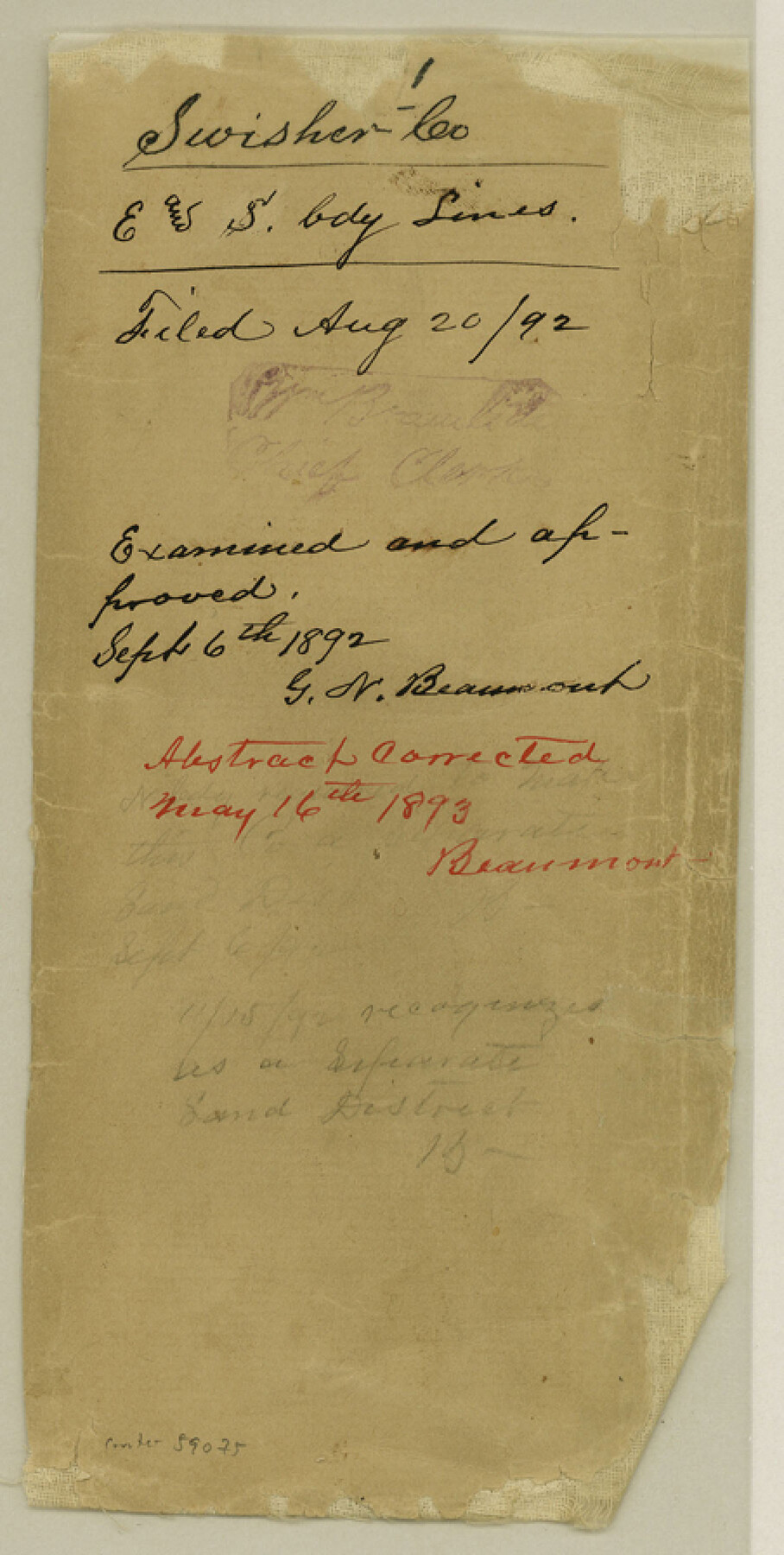
Swisher County Boundary File 1
Swisher Co. E. and S. bdy. Lines
-
Map/Doc
59075
-
Collection
General Map Collection
-
Counties
Swisher
-
Subjects
County Boundaries
-
Height x Width
9.0 x 4.5 inches
22.9 x 11.4 cm
Part of: General Map Collection
Kimble County Sketch File 43

Print $16.00
- Digital $50.00
Kimble County Sketch File 43
2021
Size 11.0 x 8.5 inches
Map/Doc 96811
Coryell County Working Sketch 8

Print $20.00
- Digital $50.00
Coryell County Working Sketch 8
1945
Size 36.5 x 33.0 inches
Map/Doc 68215
Jasper County Working Sketch 32

Print $20.00
- Digital $50.00
Jasper County Working Sketch 32
1993
Size 18.7 x 22.7 inches
Map/Doc 66494
Culberson County Sketch File 17

Print $10.00
- Digital $50.00
Culberson County Sketch File 17
1932
Size 11.2 x 8.8 inches
Map/Doc 20180
Street guide and metropolitan map of New Orleans [Recto]
![94198, Street guide and metropolitan map of New Orleans [Recto], General Map Collection](https://historictexasmaps.com/wmedia_w700/maps/94198.tif.jpg)
Street guide and metropolitan map of New Orleans [Recto]
1963
Size 18.3 x 27.2 inches
Map/Doc 94198
Galveston County Rolled Sketch JR

Print $20.00
- Digital $50.00
Galveston County Rolled Sketch JR
1938
Size 37.5 x 36.7 inches
Map/Doc 9086
Tarrant's Key and Guide to Dallas

Print $3.00
- Digital $50.00
Tarrant's Key and Guide to Dallas
1922
Size 7.9 x 10.4 inches
Map/Doc 89257
Young County Sketch File 1

Print $8.00
- Digital $50.00
Young County Sketch File 1
1853
Size 7.9 x 9.7 inches
Map/Doc 40843
Hydrographic Survey H-6395 of Outer Coast of Padre Island; Gulf of Mexico

Print $40.00
- Digital $50.00
Hydrographic Survey H-6395 of Outer Coast of Padre Island; Gulf of Mexico
1938
Size 55.1 x 33.3 inches
Map/Doc 2697
Hispaniae Novae Sivae Magnae Recens et Vera Descriptio 1579

Print $20.00
- Digital $50.00
Hispaniae Novae Sivae Magnae Recens et Vera Descriptio 1579
1581
Size 17.9 x 23.0 inches
Map/Doc 94036
Oso Creek, Rodd Field (P-1) Sheet

Print $20.00
- Digital $50.00
Oso Creek, Rodd Field (P-1) Sheet
1942
Size 33.2 x 34.0 inches
Map/Doc 65096
Grayson County Working Sketch 21

Print $20.00
- Digital $50.00
Grayson County Working Sketch 21
1961
Size 42.6 x 26.5 inches
Map/Doc 63260
You may also like
[County Line, Roberts and Hutchinson County]
![91184, [County Line, Roberts and Hutchinson County], Twichell Survey Records](https://historictexasmaps.com/wmedia_w700/maps/91184-1.tif.jpg)
Print $20.00
- Digital $50.00
[County Line, Roberts and Hutchinson County]
1907
Size 33.7 x 7.7 inches
Map/Doc 91184
Flight Mission No. BRA-7M, Frame 23, Jefferson County

Print $20.00
- Digital $50.00
Flight Mission No. BRA-7M, Frame 23, Jefferson County
1953
Size 18.6 x 22.4 inches
Map/Doc 85474
DeWitt County

Print $40.00
- Digital $50.00
DeWitt County
1987
Size 42.6 x 53.2 inches
Map/Doc 73131
Sterling County Sketch File 14

Print $20.00
- Digital $50.00
Sterling County Sketch File 14
Size 18.9 x 16.4 inches
Map/Doc 12360
Sabine River, Dixon Sheet/Cowleach Fork of the Sabine River

Print $20.00
- Digital $50.00
Sabine River, Dixon Sheet/Cowleach Fork of the Sabine River
1935
Size 44.0 x 18.5 inches
Map/Doc 65145
Lampasas County Sketch File 5

Print $8.00
- Digital $50.00
Lampasas County Sketch File 5
1869
Size 12.8 x 7.9 inches
Map/Doc 29396
Map of the Texas & Pacific Railway Company Reserve west of the Colorado River

Print $40.00
- Digital $50.00
Map of the Texas & Pacific Railway Company Reserve west of the Colorado River
1877
Size 48.9 x 59.2 inches
Map/Doc 2233
Flight Mission No. BQY-4M, Frame 39, Harris County

Print $20.00
- Digital $50.00
Flight Mission No. BQY-4M, Frame 39, Harris County
1953
Size 18.6 x 22.3 inches
Map/Doc 85254
Flight Mission No. DQN-1K, Frame 108, Calhoun County

Print $20.00
- Digital $50.00
Flight Mission No. DQN-1K, Frame 108, Calhoun County
1953
Size 18.4 x 22.1 inches
Map/Doc 84175
Flight Mission No. DAG-23K, Frame 19, Matagorda County

Print $20.00
- Digital $50.00
Flight Mission No. DAG-23K, Frame 19, Matagorda County
1953
Size 18.5 x 22.2 inches
Map/Doc 86481
El Paso County Sketch File 31

Print $185.00
- Digital $50.00
El Paso County Sketch File 31
1968
Size 8.9 x 17.7 inches
Map/Doc 22084
San Luis Pass to East Matagorda Bay

Print $20.00
- Digital $50.00
San Luis Pass to East Matagorda Bay
1976
Size 35.1 x 46.7 inches
Map/Doc 69969