Lampasas County Sketch File 5
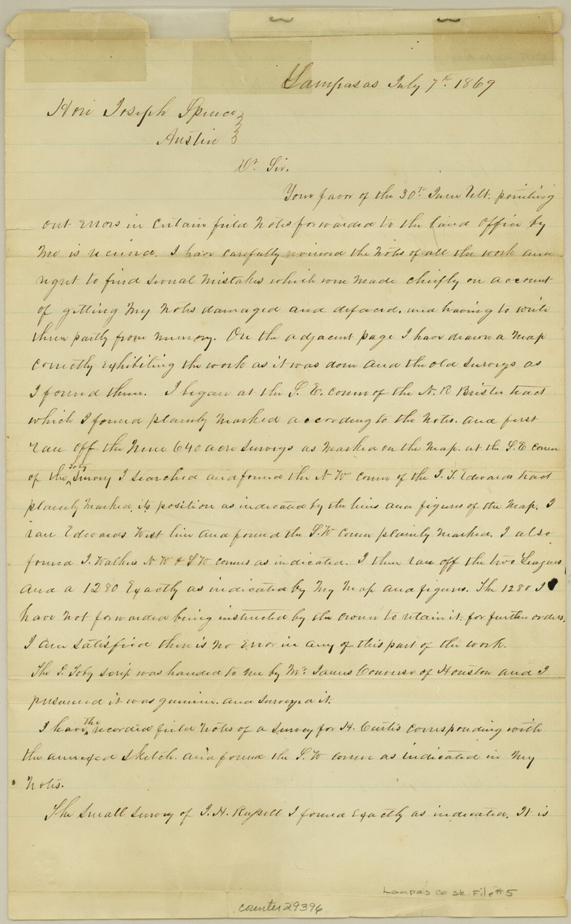
[Sketch and surveyor's statement regarding area in the north part of Lampasas and extending into Mills County]
-
Map/Doc
29396
-
Collection
General Map Collection
-
Object Dates
7/7/1869 (Creation Date)
7/17/1869 (File Date)
-
People and Organizations
H.C. Fountain (Surveyor/Engineer)
-
Counties
Lampasas Mills
-
Subjects
Surveying Sketch File
-
Height x Width
12.8 x 7.9 inches
32.5 x 20.1 cm
-
Medium
paper, manuscript
Part of: General Map Collection
Yoakum County Rolled Sketch 1

Print $20.00
- Digital $50.00
Yoakum County Rolled Sketch 1
1939
Size 40.5 x 37.5 inches
Map/Doc 10162
Glasscock County Working Sketch Graphic Index

Print $20.00
- Digital $50.00
Glasscock County Working Sketch Graphic Index
1933
Size 43.7 x 37.0 inches
Map/Doc 76554
United States - Gulf Coast Texas - Southern part of Laguna Madre

Print $20.00
- Digital $50.00
United States - Gulf Coast Texas - Southern part of Laguna Madre
1933
Size 26.9 x 18.3 inches
Map/Doc 72952
Tom Green County Sketch File 82

Print $20.00
- Digital $50.00
Tom Green County Sketch File 82
1888
Size 18.5 x 20.9 inches
Map/Doc 12454
Madison County Working Sketch 6

Print $2.00
- Digital $50.00
Madison County Working Sketch 6
1982
Size 10.5 x 7.7 inches
Map/Doc 70768
Aransas Pass to Baffin Bay

Print $20.00
- Digital $50.00
Aransas Pass to Baffin Bay
1961
Size 42.1 x 35.4 inches
Map/Doc 73414
Hartley County Sketch File 1a

Print $4.00
- Digital $50.00
Hartley County Sketch File 1a
1890
Size 7.8 x 8.2 inches
Map/Doc 26083
Presidio County Sketch File 85

Print $6.00
- Digital $50.00
Presidio County Sketch File 85
1950
Size 14.3 x 8.9 inches
Map/Doc 34745
Gaines County Working Sketch 5

Print $20.00
- Digital $50.00
Gaines County Working Sketch 5
1940
Size 24.2 x 41.4 inches
Map/Doc 69305
Blanco County Sketch File 30

Print $5.00
- Digital $50.00
Blanco County Sketch File 30
Size 9.1 x 10.6 inches
Map/Doc 14627
Panola County Working Sketch 31

Print $20.00
- Digital $50.00
Panola County Working Sketch 31
1981
Map/Doc 71440
Terrell County Rolled Sketch 60

Print $20.00
- Digital $50.00
Terrell County Rolled Sketch 60
1998
Size 13.2 x 38.1 inches
Map/Doc 7976
You may also like
Henderson County Working Sketch 6

Print $20.00
- Digital $50.00
Henderson County Working Sketch 6
1919
Size 24.4 x 17.6 inches
Map/Doc 66139
Flight Mission No. DQN-2K, Frame 28, Calhoun County

Print $20.00
- Digital $50.00
Flight Mission No. DQN-2K, Frame 28, Calhoun County
1953
Size 18.6 x 22.2 inches
Map/Doc 84235
Reeves County Working Sketch 43

Print $20.00
- Digital $50.00
Reeves County Working Sketch 43
1974
Size 43.2 x 37.1 inches
Map/Doc 63486
Liberty County Sketch File 36a

Print $4.00
- Digital $50.00
Liberty County Sketch File 36a
Size 8.6 x 5.6 inches
Map/Doc 29974
Official Highway Map of Texas

Print $20.00
Official Highway Map of Texas
1928
Size 42.3 x 46.2 inches
Map/Doc 79746
[Atlas D, Table of Contents]
![78350, [Atlas D, Table of Contents], General Map Collection](https://historictexasmaps.com/wmedia_w700/maps/78350.tif.jpg)
Print $20.00
- Digital $50.00
[Atlas D, Table of Contents]
Size 18.3 x 9.5 inches
Map/Doc 78350
Right of Way and Track Map - Houston & Texas Central R.R. operated by the T. and N. O. R.R. Co. - Main Line

Print $40.00
- Digital $50.00
Right of Way and Track Map - Houston & Texas Central R.R. operated by the T. and N. O. R.R. Co. - Main Line
1918
Size 25.2 x 57.8 inches
Map/Doc 82859
Galveston County Rolled Sketch 13

Print $20.00
- Digital $50.00
Galveston County Rolled Sketch 13
1890
Size 34.5 x 24.2 inches
Map/Doc 5953
DeWitt County Boundary File 2a

Print $2.00
- Digital $50.00
DeWitt County Boundary File 2a
Size 10.7 x 8.1 inches
Map/Doc 52513
Starr County Rolled Sketch 20

Print $20.00
- Digital $50.00
Starr County Rolled Sketch 20
1921
Size 23.6 x 15.4 inches
Map/Doc 7804
McLennan County Sketch File 13

Print $4.00
- Digital $50.00
McLennan County Sketch File 13
1873
Size 10.7 x 8.1 inches
Map/Doc 31267
Flight Mission No. BRE-2P, Frame 129, Nueces County

Print $20.00
- Digital $50.00
Flight Mission No. BRE-2P, Frame 129, Nueces County
1956
Size 18.6 x 22.7 inches
Map/Doc 86802