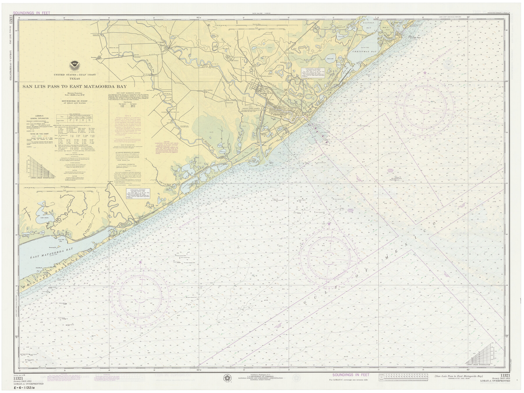
San Luis Pass to East Matagorda Bay
K-6-1283d
-
Map/Doc
69969
-
Collection
General Map Collection
-
Object Dates
1/17/1976 (Creation Date)
-
Counties
Galveston Matagorda Brazoria
-
Subjects
Nautical Charts
-
Height x Width
35.1 x 46.7 inches
89.2 x 118.6 cm
Part of: General Map Collection
Schleicher County

Print $40.00
- Digital $50.00
Schleicher County
1940
Size 38.7 x 54.9 inches
Map/Doc 73285
Val Verde County Rolled Sketch 72

Print $20.00
- Digital $50.00
Val Verde County Rolled Sketch 72
Size 15.2 x 28.5 inches
Map/Doc 8134
Walker County Working Sketch 9

Print $20.00
- Digital $50.00
Walker County Working Sketch 9
1935
Size 23.7 x 27.0 inches
Map/Doc 72289
Erath County Sketch File 12a

Print $4.00
- Digital $50.00
Erath County Sketch File 12a
1871
Size 12.7 x 8.2 inches
Map/Doc 22283
Jackson County Sketch File 22

Print $10.00
- Digital $50.00
Jackson County Sketch File 22
Size 11.2 x 8.7 inches
Map/Doc 27698
Aransas County NRC Article 33.136 Location Key Sheet

Print $20.00
- Digital $50.00
Aransas County NRC Article 33.136 Location Key Sheet
1975
Size 27.0 x 23.0 inches
Map/Doc 77004

Flight Mission No. CRK-7P, Frame 28, Refugio County

Print $20.00
- Digital $50.00
Flight Mission No. CRK-7P, Frame 28, Refugio County
1956
Size 18.4 x 22.1 inches
Map/Doc 86948
Edwards County Sketch File 55

Print $4.00
- Digital $50.00
Edwards County Sketch File 55
1982
Size 9.1 x 14.5 inches
Map/Doc 21806
[Brown County]
![3337, [Brown County], General Map Collection](https://historictexasmaps.com/wmedia_w700/maps/3337-1.tif.jpg)
Print $20.00
- Digital $50.00
[Brown County]
1863
Size 25.4 x 22.5 inches
Map/Doc 3337
Sterling County Rolled Sketch 16

Print $40.00
- Digital $50.00
Sterling County Rolled Sketch 16
1951
Size 73.6 x 43.0 inches
Map/Doc 9948
Howard County Boundary File 3a

Print $62.00
- Digital $50.00
Howard County Boundary File 3a
Size 3.9 x 8.7 inches
Map/Doc 55155
You may also like
Galveston County Sketch File 30

Print $20.00
- Digital $50.00
Galveston County Sketch File 30
1915
Size 43.0 x 30.7 inches
Map/Doc 10455
Navarro County Working Sketch 9

Print $20.00
- Digital $50.00
Navarro County Working Sketch 9
1956
Size 22.8 x 20.6 inches
Map/Doc 71239
[Block M24, Surveys 1-8 and vicinity]
![91231, [Block M24, Surveys 1-8 and vicinity], Twichell Survey Records](https://historictexasmaps.com/wmedia_w700/maps/91231-1.tif.jpg)
Print $20.00
- Digital $50.00
[Block M24, Surveys 1-8 and vicinity]
1909
Size 16.4 x 18.2 inches
Map/Doc 91231
Pecos County Sketch File 56

Print $20.00
- Digital $50.00
Pecos County Sketch File 56
Size 35.6 x 28.6 inches
Map/Doc 10571
Kinney County Working Sketch 2

Print $20.00
- Digital $50.00
Kinney County Working Sketch 2
1886
Size 20.0 x 20.4 inches
Map/Doc 70184
[H. & T. C. 49, Part of G. C. & S. 35, Capitol Leagues 206, 207, 214, 215]
![90688, [H. & T. C. 49, Part of G. C. & S. 35, Capitol Leagues 206, 207, 214, 215], Twichell Survey Records](https://historictexasmaps.com/wmedia_w700/maps/90688-1.tif.jpg)
Print $20.00
- Digital $50.00
[H. & T. C. 49, Part of G. C. & S. 35, Capitol Leagues 206, 207, 214, 215]
1903
Size 13.1 x 13.2 inches
Map/Doc 90688
Angelina County Working Sketch 40

Print $20.00
- Digital $50.00
Angelina County Working Sketch 40
1960
Size 14.2 x 18.8 inches
Map/Doc 67123
Oldham County Working Sketch 9

Print $20.00
- Digital $50.00
Oldham County Working Sketch 9
1982
Size 33.3 x 37.2 inches
Map/Doc 71331
Comal County Rolled Sketch 4

Print $20.00
- Digital $50.00
Comal County Rolled Sketch 4
1981
Size 18.8 x 24.5 inches
Map/Doc 5539
Henderson County Working Sketch 3

Print $20.00
- Digital $50.00
Henderson County Working Sketch 3
Size 28.5 x 38.3 inches
Map/Doc 66136
Orange County Sketch File 34

Print $20.00
- Digital $50.00
Orange County Sketch File 34
1929
Size 23.5 x 27.7 inches
Map/Doc 12126
Flight Mission No. DCL-5C, Frame 28, Kenedy County

Print $20.00
- Digital $50.00
Flight Mission No. DCL-5C, Frame 28, Kenedy County
1943
Size 18.5 x 22.3 inches
Map/Doc 85840