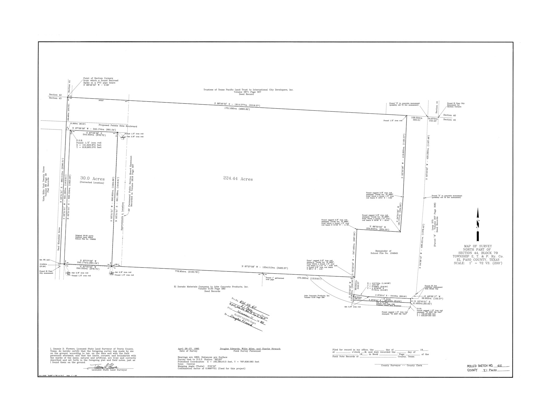
El Paso County Rolled Sketch 62
Map of survey, north part of section 44, Block 79 Township 2, T. & P. Ry. Co.
-
Map/Doc
5854
-
Collection
General Map Collection
-
Object Dates
1995/4/27 (Survey Date)
1995/11/11 (File Date)
-
People and Organizations
Jimmie D. Flowers (Surveyor/Engineer)
Douglas Edwards (Chainman/Field Personnel)
Willie Miles (Chainman/Field Personnel)
Charlie Strauch (Chainman/Field Personnel)
-
Counties
El Paso
-
Subjects
Surveying Rolled Sketch
-
Height x Width
30.0 x 39.4 inches
76.2 x 100.1 cm
-
Scale
1" = 72 varas
-
Comments
See School File 154708.
Part of: General Map Collection
Houston including Bellaire, Bunker Hill, Galena Park, Hedwig, Hilshire, Hunters Creek, Jacinto City, Jersey Village, Missouri City, Pasadena, Piney Point, South Houston, Spring Valley, West University Place and adjoining communities [Recto]
![94179, Houston including Bellaire, Bunker Hill, Galena Park, Hedwig, Hilshire, Hunters Creek, Jacinto City, Jersey Village, Missouri City, Pasadena, Piney Point, South Houston, Spring Valley, West University Place and adjoining communities [Recto], General Map Collection](https://historictexasmaps.com/wmedia_w700/maps/94179.tif.jpg)
Houston including Bellaire, Bunker Hill, Galena Park, Hedwig, Hilshire, Hunters Creek, Jacinto City, Jersey Village, Missouri City, Pasadena, Piney Point, South Houston, Spring Valley, West University Place and adjoining communities [Recto]
Size 27.1 x 42.6 inches
Map/Doc 94179
Flight Mission No. BRA-7M, Frame 200, Jefferson County

Print $20.00
- Digital $50.00
Flight Mission No. BRA-7M, Frame 200, Jefferson County
1953
Size 18.8 x 22.4 inches
Map/Doc 85568
Map of Starr County State of Texas

Print $20.00
- Digital $50.00
Map of Starr County State of Texas
1911
Size 25.1 x 23.2 inches
Map/Doc 4048
Glasscock County Sketch File 19

Print $20.00
- Digital $50.00
Glasscock County Sketch File 19
Size 21.4 x 16.8 inches
Map/Doc 11563
Terrell County Working Sketch 58

Print $40.00
- Digital $50.00
Terrell County Working Sketch 58
1960
Size 36.3 x 48.9 inches
Map/Doc 69579
Midland County Working Sketch 9
Print $20.00
- Digital $50.00
Midland County Working Sketch 9
1951
Size 42.6 x 35.9 inches
Map/Doc 70989
Boundary Between the United States & Mexico Agreed upon by the Joint Commission under the Treaty of Guadalupe Hidalgo

Print $20.00
- Digital $50.00
Boundary Between the United States & Mexico Agreed upon by the Joint Commission under the Treaty of Guadalupe Hidalgo
1853
Size 18.2 x 26.4 inches
Map/Doc 72883
Oldham County Rolled Sketch 2A

Print $40.00
- Digital $50.00
Oldham County Rolled Sketch 2A
1886
Size 35.9 x 55.6 inches
Map/Doc 9640
Sutton County Sketch File Z

Print $20.00
- Digital $50.00
Sutton County Sketch File Z
Size 21.8 x 28.3 inches
Map/Doc 12400
[Beaumont, Sour Lake and Western Ry. Right of Way and Alignment - Frisco]
![64119, [Beaumont, Sour Lake and Western Ry. Right of Way and Alignment - Frisco], General Map Collection](https://historictexasmaps.com/wmedia_w700/maps/64119.tif.jpg)
Print $20.00
- Digital $50.00
[Beaumont, Sour Lake and Western Ry. Right of Way and Alignment - Frisco]
1910
Size 20.0 x 45.8 inches
Map/Doc 64119
Cottle County Sketch File 16a

Print $64.00
- Digital $50.00
Cottle County Sketch File 16a
1911
Size 11.5 x 8.9 inches
Map/Doc 19522
Fayette County Sketch File 1

Print $4.00
- Digital $50.00
Fayette County Sketch File 1
Size 8.4 x 7.2 inches
Map/Doc 22497
You may also like
Robertson County Rolled Sketch 6

Print $20.00
- Digital $50.00
Robertson County Rolled Sketch 6
Size 22.8 x 15.6 inches
Map/Doc 7512
Travis County Working Sketch 68

Print $20.00
- Digital $50.00
Travis County Working Sketch 68
2019
Size 23.8 x 36.0 inches
Map/Doc 95687
Etats-Unis de l'Amérique Septentrionale avec les Isles Royale, de Terre Neuve de St. Jean, L'Acadie &c.

Print $20.00
- Digital $50.00
Etats-Unis de l'Amérique Septentrionale avec les Isles Royale, de Terre Neuve de St. Jean, L'Acadie &c.
1785
Size 20.9 x 28.2 inches
Map/Doc 93679
Map of The Surveyed Part of Peters Colony Texas

Print $40.00
- Digital $50.00
Map of The Surveyed Part of Peters Colony Texas
1852
Size 53.0 x 28.1 inches
Map/Doc 1964
Young County Sketch File 12

Print $4.00
- Digital $50.00
Young County Sketch File 12
1889
Size 8.5 x 13.6 inches
Map/Doc 40876
Archer County Sketch File 17

Print $4.00
- Digital $50.00
Archer County Sketch File 17
1901
Size 11.3 x 8.6 inches
Map/Doc 13653
Map of Kinney County

Print $20.00
- Digital $50.00
Map of Kinney County
1876
Size 24.0 x 32.4 inches
Map/Doc 3775
Flight Mission No. DQN-6K, Frame 73, Calhoun County

Print $20.00
- Digital $50.00
Flight Mission No. DQN-6K, Frame 73, Calhoun County
1953
Size 18.5 x 22.1 inches
Map/Doc 84445
Shelby County Rolled Sketch 10

Print $20.00
- Digital $50.00
Shelby County Rolled Sketch 10
Size 16.2 x 27.3 inches
Map/Doc 7778

Flight Mission No. DQN-2K, Frame 28, Calhoun County

Print $20.00
- Digital $50.00
Flight Mission No. DQN-2K, Frame 28, Calhoun County
1953
Size 18.6 x 22.2 inches
Map/Doc 84235
Dickens County Sketch File 37

Print $8.00
- Digital $50.00
Dickens County Sketch File 37
Size 10.3 x 8.3 inches
Map/Doc 21044