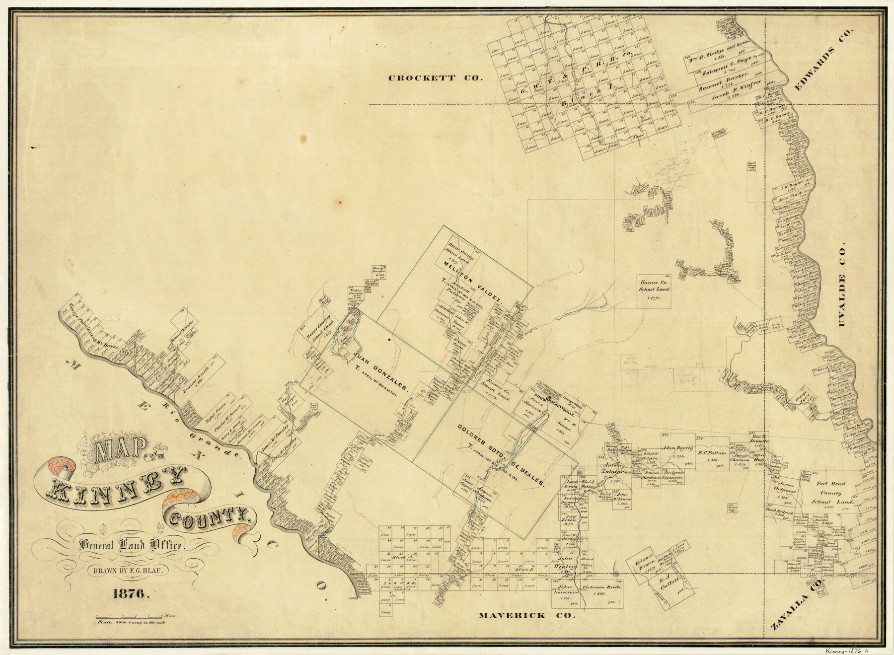
Map of Kinney County
-
Map/Doc
3775
-
Collection
General Map Collection
-
Object Dates
1876 (Creation Date)
-
People and Organizations
F.G. Blau (Draftsman)
-
Counties
Kinney
-
Subjects
County
-
Height x Width
24.0 x 32.4 inches
61.0 x 82.3 cm
-
Features
Fort Clark
Muela Creek
Chaparosa Creek
Woodhull Creek
Salado Creek
Rio Grande
West Prong of Nueces River
Elm Creek
Turkey's Creek
East Fork of Piedras Pinto Creek
Las Moras Creek
Brackettsville [sic]
West Fork of Nueces River
Maverick Creek
San Pedro Creek
Stampede Creek
San Felipe Creek
Piedra Pinto Creek
Zoquete Creek
West Fork [of Piedra Pinto Creek]
West Fork [of Xoquete Creek]
Bluff Creek
Live Oak Creek
Part of: General Map Collection
Brazoria County Sketch File 9

Print $6.00
- Digital $50.00
Brazoria County Sketch File 9
Size 14.0 x 9.0 inches
Map/Doc 14936
Intracoastal Waterway - Laguna Madre - Chubby Island to Stover Point including the Arroyo Colorado, Texas

Print $20.00
- Digital $50.00
Intracoastal Waterway - Laguna Madre - Chubby Island to Stover Point including the Arroyo Colorado, Texas
1976
Size 15.6 x 43.8 inches
Map/Doc 75900
Sutton County Working Sketch Graphic Index, Sheet 1 (Sketches 1 to 24)

Print $40.00
- Digital $50.00
Sutton County Working Sketch Graphic Index, Sheet 1 (Sketches 1 to 24)
1941
Size 41.9 x 55.3 inches
Map/Doc 76705
Trinity County Sketch File 18

Print $20.00
- Digital $50.00
Trinity County Sketch File 18
Size 21.9 x 20.7 inches
Map/Doc 12483
Childress County Sketch File 16

Print $8.00
- Digital $50.00
Childress County Sketch File 16
1888
Size 13.9 x 8.5 inches
Map/Doc 18282
[University Lands]
![62966, [University Lands], General Map Collection](https://historictexasmaps.com/wmedia_w700/maps/62966.tif.jpg)
Print $40.00
- Digital $50.00
[University Lands]
1885
Size 52.9 x 39.5 inches
Map/Doc 62966
Coke County Sketch File 13

Print $40.00
- Digital $50.00
Coke County Sketch File 13
Size 17.5 x 13.1 inches
Map/Doc 18596
Baylor County Sketch File 13

Print $4.00
- Digital $50.00
Baylor County Sketch File 13
1856
Size 13.5 x 8.5 inches
Map/Doc 14179
Burnet County Working Sketch 11

Print $20.00
- Digital $50.00
Burnet County Working Sketch 11
1975
Size 26.5 x 28.9 inches
Map/Doc 67854
Starr County Working Sketch 20

Print $20.00
- Digital $50.00
Starr County Working Sketch 20
1982
Size 29.5 x 35.2 inches
Map/Doc 63936
Erath County Working Sketch 37

Print $20.00
- Digital $50.00
Erath County Working Sketch 37
1973
Size 21.4 x 22.6 inches
Map/Doc 69118
Red River County Sketch File 15

Print $4.00
- Digital $50.00
Red River County Sketch File 15
1863
Size 12.1 x 7.2 inches
Map/Doc 35137
You may also like
Angelina County Working Sketch 49

Print $20.00
- Digital $50.00
Angelina County Working Sketch 49
1980
Size 38.2 x 29.5 inches
Map/Doc 67132
Corpus Christi Bay, Texas

Print $40.00
- Digital $50.00
Corpus Christi Bay, Texas
1867
Size 33.9 x 54.8 inches
Map/Doc 73470
Atascosa County Boundary File 6

Print $34.00
- Digital $50.00
Atascosa County Boundary File 6
Size 9.1 x 23.0 inches
Map/Doc 50205
Liberty County Rolled Sketch P

Print $33.00
- Digital $50.00
Liberty County Rolled Sketch P
Size 10.3 x 16.5 inches
Map/Doc 46545

Terrell County Rolled Sketch 19

Print $20.00
- Digital $50.00
Terrell County Rolled Sketch 19
1884
Size 22.4 x 26.9 inches
Map/Doc 7927
Maps of Gulf Intracoastal Waterway, Texas - Sabine River to the Rio Grande and connecting waterways including ship channels

Print $20.00
- Digital $50.00
Maps of Gulf Intracoastal Waterway, Texas - Sabine River to the Rio Grande and connecting waterways including ship channels
1966
Size 14.5 x 22.2 inches
Map/Doc 61932
Castro County Sketch File 7

Print $10.00
- Digital $50.00
Castro County Sketch File 7
1905
Size 10.9 x 8.0 inches
Map/Doc 17495
Mitchell County

Print $20.00
- Digital $50.00
Mitchell County
1889
Size 44.3 x 37.8 inches
Map/Doc 66935
Geographical, Statistical, and Historical Map of the District of Columbia

Print $20.00
- Digital $50.00
Geographical, Statistical, and Historical Map of the District of Columbia
Size 18.0 x 22.4 inches
Map/Doc 97102
Map of City of Brownfield, Texas

Print $20.00
- Digital $50.00
Map of City of Brownfield, Texas
1953
Size 44.4 x 40.1 inches
Map/Doc 89890
Outer Continental Shelf Leasing Maps (Texas Offshore Operations)

Print $20.00
- Digital $50.00
Outer Continental Shelf Leasing Maps (Texas Offshore Operations)
1954
Size 20.3 x 15.5 inches
Map/Doc 75839