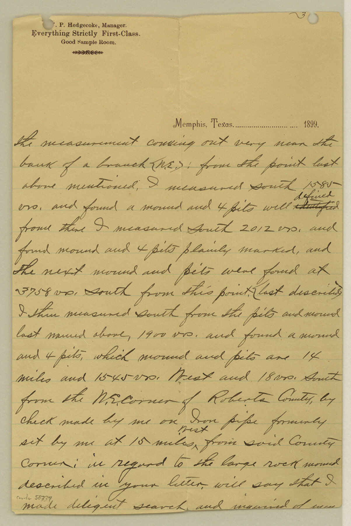
Roberts County Boundary File 2a
Letter W. P. Hedgecocke 8/21/999 Explanatory N. E. Corner Roberts
-
Map/Doc
58339
-
Collection
General Map Collection
-
Counties
Roberts
-
Subjects
County Boundaries
-
Height x Width
9.5 x 6.4 inches
24.1 x 16.3 cm
Part of: General Map Collection
Liberty County Sketch File 33a

Print $4.00
- Digital $50.00
Liberty County Sketch File 33a
1874
Size 7.9 x 8.2 inches
Map/Doc 29969
McMullen County Working Sketch 7

Print $20.00
- Digital $50.00
McMullen County Working Sketch 7
1926
Size 20.7 x 17.5 inches
Map/Doc 70708

Cottle County Working Sketch 11

Print $20.00
- Digital $50.00
Cottle County Working Sketch 11
1943
Size 19.2 x 24.1 inches
Map/Doc 68321
Castro County Working Sketch Graphic Index

Print $20.00
- Digital $50.00
Castro County Working Sketch Graphic Index
1932
Size 43.1 x 38.2 inches
Map/Doc 76490
Austin County Sketch File EF

Print $40.00
- Digital $50.00
Austin County Sketch File EF
1895
Size 15.1 x 17.0 inches
Map/Doc 10879
Flight Mission No. BRE-1P, Frame 147, Nueces County

Print $20.00
- Digital $50.00
Flight Mission No. BRE-1P, Frame 147, Nueces County
1956
Size 18.5 x 22.3 inches
Map/Doc 86707
Map of Texas and the countries adjacent compiled in the Bureau of the Corps of Topographical Engineers from the best authorities for the State Department

Print $20.00
- Digital $50.00
Map of Texas and the countries adjacent compiled in the Bureau of the Corps of Topographical Engineers from the best authorities for the State Department
1844
Size 26.1 x 18.2 inches
Map/Doc 72715

Geological Survey of Texas, First Annual Report, Plate II, Figures 6, 7, 8, 9

Print $20.00
- Digital $50.00
Geological Survey of Texas, First Annual Report, Plate II, Figures 6, 7, 8, 9
Size 17.1 x 18.1 inches
Map/Doc 75114
Railroad Track Map, H&TCRRCo., Falls County, Texas

Print $4.00
- Digital $50.00
Railroad Track Map, H&TCRRCo., Falls County, Texas
1918
Size 11.5 x 18.4 inches
Map/Doc 62846
Map of DeWitt County

Print $20.00
- Digital $50.00
Map of DeWitt County
1881
Size 22.9 x 26.5 inches
Map/Doc 3477
You may also like
Wheelock Second Addition

Print $20.00
- Digital $50.00
Wheelock Second Addition
1952
Size 9.3 x 24.3 inches
Map/Doc 92308
Childress County Rolled Sketch 8A

Print $20.00
- Digital $50.00
Childress County Rolled Sketch 8A
Size 18.2 x 12.9 inches
Map/Doc 5443
[Sketch of F.R. Lehmann surveys on the Rio Grande]
![554, [Sketch of F.R. Lehmann surveys on the Rio Grande], Maddox Collection](https://historictexasmaps.com/wmedia_w700/maps/554.tif.jpg)
Print $20.00
- Digital $50.00
[Sketch of F.R. Lehmann surveys on the Rio Grande]
Size 14.7 x 16.8 inches
Map/Doc 554
Working Sketch Showing Scrap Lands in Hale County

Print $20.00
- Digital $50.00
Working Sketch Showing Scrap Lands in Hale County
1915
Size 22.7 x 11.1 inches
Map/Doc 90742
Sunny San Antonio - The Winter Playground of America

Sunny San Antonio - The Winter Playground of America
1920
Size 9.4 x 7.9 inches
Map/Doc 97040
Railroad Track Map, H&TCRRCo., Falls County, Texas

Print $4.00
- Digital $50.00
Railroad Track Map, H&TCRRCo., Falls County, Texas
1918
Size 11.7 x 18.6 inches
Map/Doc 62835
San Patricio County Boundary File 76

Print $25.00
- Digital $50.00
San Patricio County Boundary File 76
Size 9.2 x 7.6 inches
Map/Doc 58563
The Judicial District/County of Trinity. Created, December 7, 1841

Print $20.00
The Judicial District/County of Trinity. Created, December 7, 1841
2020
Size 14.7 x 21.7 inches
Map/Doc 96350
Erath County Sketch File 8a

Print $6.00
- Digital $50.00
Erath County Sketch File 8a
1853
Size 15.9 x 11.0 inches
Map/Doc 22271
[North line of T. & P. Block 31, Township 6N]
![90554, [North line of T. & P. Block 31, Township 6N], Twichell Survey Records](https://historictexasmaps.com/wmedia_w700/maps/90554-1.tif.jpg)
Print $2.00
- Digital $50.00
[North line of T. & P. Block 31, Township 6N]
Size 7.5 x 4.7 inches
Map/Doc 90554
Flight Mission No. CRK-3P, Frame 176, Refugio County

Print $20.00
- Digital $50.00
Flight Mission No. CRK-3P, Frame 176, Refugio County
1956
Size 18.3 x 22.2 inches
Map/Doc 86923
Dickens County Rolled Sketch 10

Print $20.00
- Digital $50.00
Dickens County Rolled Sketch 10
Size 43.0 x 31.9 inches
Map/Doc 8789