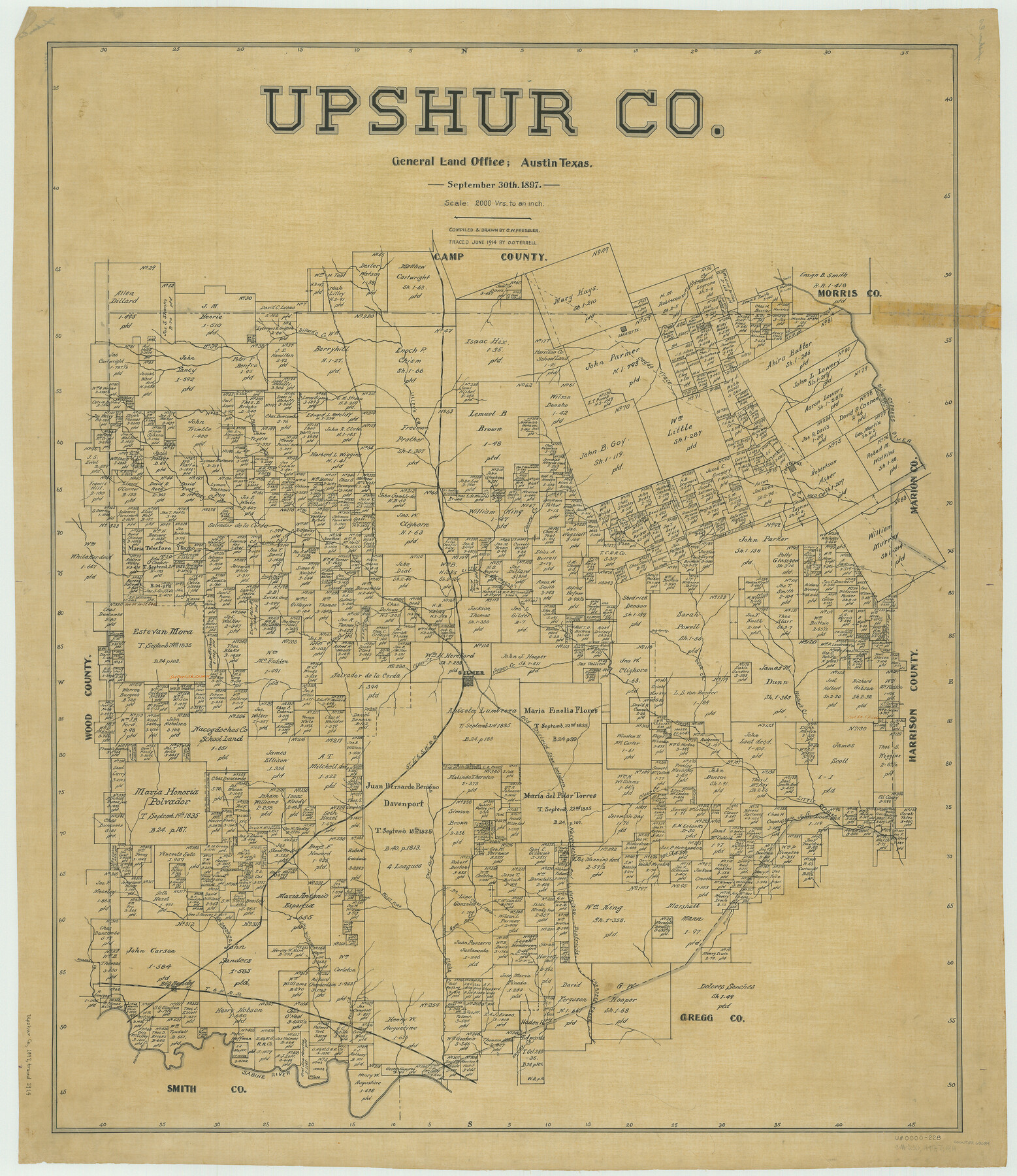
Upshur Co.
-
Map/Doc
63084
-
Collection
General Map Collection
-
Object Dates
1897/9/30 (Creation Date)
-
People and Organizations
Texas General Land Office (Publisher)
Chas. W. Pressler (Compiler)
Chas. W. Pressler (Draftsman)
-
Counties
Upshur
-
Subjects
County
-
Height x Width
37.3 x 32.3 inches
94.7 x 82.0 cm
-
Comments
Traced in June 1914 by O. O. Terrell.
Part of: General Map Collection
Culberson County Sketch File 23

Print $10.00
- Digital $50.00
Culberson County Sketch File 23
1938
Size 14.2 x 8.6 inches
Map/Doc 20238
Harris County Sketch File 21

Print $4.00
- Digital $50.00
Harris County Sketch File 21
1862
Size 13.1 x 8.2 inches
Map/Doc 25373
Pecos County Rolled Sketch 142

Print $20.00
- Digital $50.00
Pecos County Rolled Sketch 142
Size 26.9 x 41.9 inches
Map/Doc 7276
Calhoun County Rolled Sketch 14

Print $20.00
- Digital $50.00
Calhoun County Rolled Sketch 14
Size 21.9 x 40.1 inches
Map/Doc 5459
McLennan County Working Sketch 2

Print $20.00
- Digital $50.00
McLennan County Working Sketch 2
1941
Size 21.8 x 30.0 inches
Map/Doc 70695
Parker County Working Sketch 20

Print $20.00
- Digital $50.00
Parker County Working Sketch 20
2005
Map/Doc 83581
Richardson's New Map of the State of Texas prepared for the Texas Almanac

Print $20.00
- Digital $50.00
Richardson's New Map of the State of Texas prepared for the Texas Almanac
1873
Size 19.8 x 27.1 inches
Map/Doc 96873
Bexar County Boundary File 2a

Print $12.00
- Digital $50.00
Bexar County Boundary File 2a
Size 10.0 x 8.1 inches
Map/Doc 50530
Val Verde County Working Sketch 87

Print $20.00
- Digital $50.00
Val Verde County Working Sketch 87
1973
Size 37.1 x 33.8 inches
Map/Doc 72222
Kimble County

Print $40.00
- Digital $50.00
Kimble County
1930
Size 43.8 x 49.2 inches
Map/Doc 73207
Flight Mission No. CGI-1N, Frame 213, Cameron County

Print $20.00
- Digital $50.00
Flight Mission No. CGI-1N, Frame 213, Cameron County
1955
Size 18.5 x 22.2 inches
Map/Doc 84522
Crockett County Sketch File 94

Print $6.00
- Digital $50.00
Crockett County Sketch File 94
1940
Size 9.2 x 12.3 inches
Map/Doc 19950
You may also like
The Republic County of Matagorda. December 24, 1844

Print $20.00
The Republic County of Matagorda. December 24, 1844
2020
Size 21.0 x 21.7 inches
Map/Doc 96223
Crockett County Rolled Sketch S

Print $20.00
- Digital $50.00
Crockett County Rolled Sketch S
Size 8.3 x 21.2 inches
Map/Doc 5639
Flight Mission No. DQO-7K, Frame 75, Galveston County

Print $20.00
- Digital $50.00
Flight Mission No. DQO-7K, Frame 75, Galveston County
1952
Size 18.9 x 22.4 inches
Map/Doc 85102
Brewster County Rolled Sketch 11A

Print $20.00
- Digital $50.00
Brewster County Rolled Sketch 11A
1881
Size 24.9 x 23.0 inches
Map/Doc 5192
Wichita County Sketch File D

Print $22.00
- Digital $50.00
Wichita County Sketch File D
1919
Size 12.0 x 8.6 inches
Map/Doc 40061
[Sketch for Mineral Application 15559 - Hutchinson County, Canadian River]
![65681, [Sketch for Mineral Application 15559 - Hutchinson County, Canadian River], General Map Collection](https://historictexasmaps.com/wmedia_w700/maps/65681-1.tif.jpg)
Print $20.00
- Digital $50.00
[Sketch for Mineral Application 15559 - Hutchinson County, Canadian River]
1926
Size 13.2 x 12.0 inches
Map/Doc 65681
[St. L. S-W. Ry. of Texas Map of Lufkin Branch in Angelina County, Texas]
![64561, [St. L. S-W. Ry. of Texas Map of Lufkin Branch in Angelina County, Texas], General Map Collection](https://historictexasmaps.com/wmedia_w700/maps/64561-1.tif.jpg)
Print $40.00
- Digital $50.00
[St. L. S-W. Ry. of Texas Map of Lufkin Branch in Angelina County, Texas]
1913
Size 25.4 x 121.3 inches
Map/Doc 64561
Trinity River, Levee Improvement Districts, Widths of Floodways/Pilot Grove Creek and East Fork Trinity River

Print $6.00
- Digital $50.00
Trinity River, Levee Improvement Districts, Widths of Floodways/Pilot Grove Creek and East Fork Trinity River
1920
Size 33.0 x 17.1 inches
Map/Doc 65259
Corpus Christi Bay, Texas

Print $40.00
- Digital $50.00
Corpus Christi Bay, Texas
1867
Size 33.9 x 54.8 inches
Map/Doc 73470
Leon County Working Sketch 47

Print $20.00
- Digital $50.00
Leon County Working Sketch 47
1980
Size 29.3 x 25.8 inches
Map/Doc 70446
Childress County Rolled Sketch 3

Print $40.00
- Digital $50.00
Childress County Rolled Sketch 3
Size 21.1 x 57.0 inches
Map/Doc 8598
Presidio County Sketch File 86

Print $4.00
- Digital $50.00
Presidio County Sketch File 86
1950
Size 16.1 x 21.8 inches
Map/Doc 11724