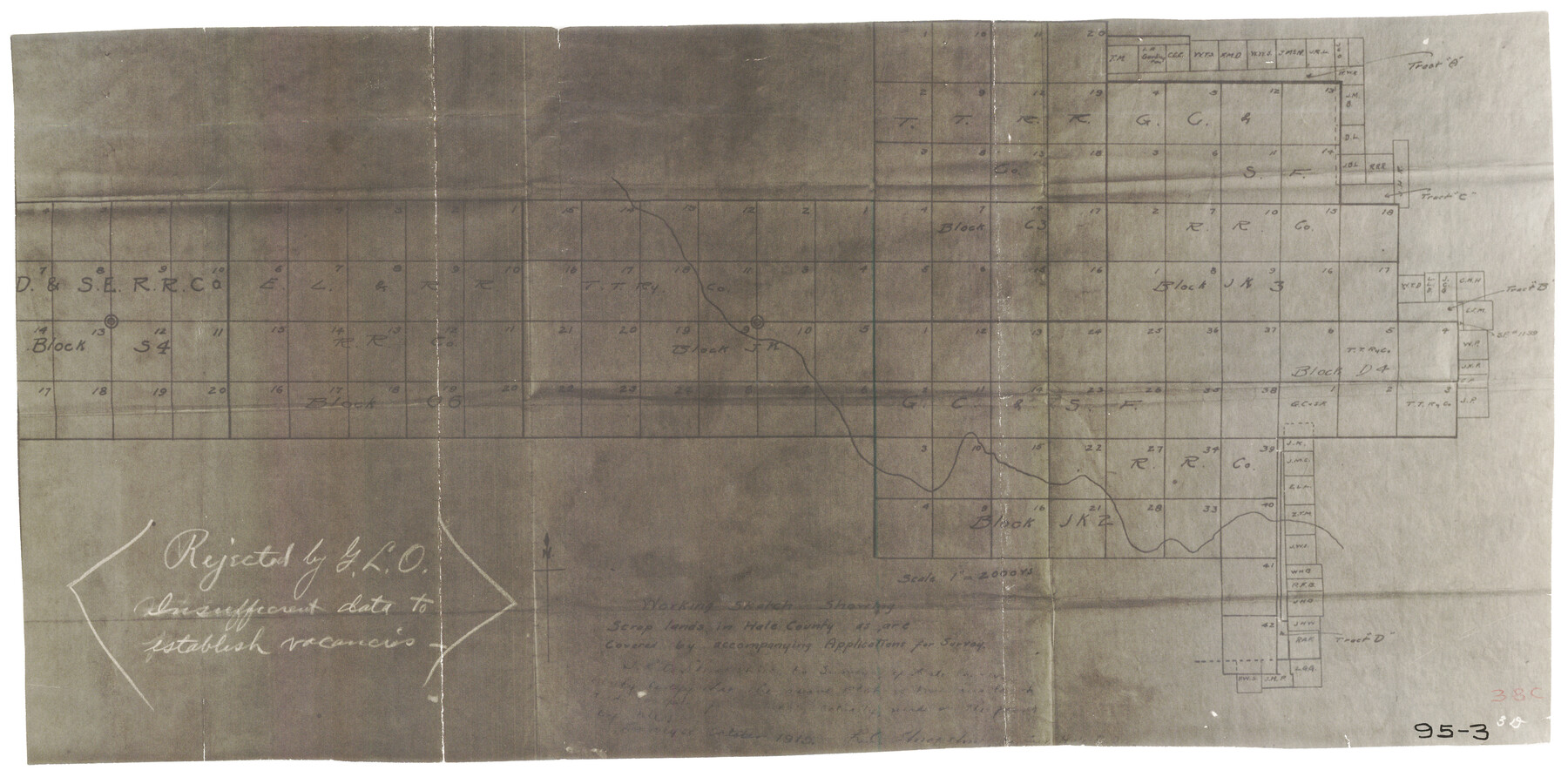
Working Sketch Showing Scrap Lands in Hale County
95-3
-
Map/Doc
90742
-
Collection
Twichell Survey Records
-
Object Dates
1915 (Creation Date)
-
Counties
Hale
-
Height x Width
22.7 x 11.1 inches
57.7 x 28.2 cm
Part of: Twichell Survey Records
Map of Edwards County, Texas

Print $20.00
- Digital $50.00
Map of Edwards County, Texas
Size 21.5 x 18.2 inches
Map/Doc 92635
Revised Plat, Section J, Tech Memorial Park, Inc., Infants Garden

Print $20.00
- Digital $50.00
Revised Plat, Section J, Tech Memorial Park, Inc., Infants Garden
1961
Size 29.1 x 33.7 inches
Map/Doc 92786
Block 3, C. D. Elliston Addition

Print $20.00
- Digital $50.00
Block 3, C. D. Elliston Addition
1953
Size 14.8 x 18.3 inches
Map/Doc 92728
[Blocks R31E-R33E, Townships 12E-14E]
![92041, [Blocks R31E-R33E, Townships 12E-14E], Twichell Survey Records](https://historictexasmaps.com/wmedia_w700/maps/92041-1.tif.jpg)
Print $20.00
- Digital $50.00
[Blocks R31E-R33E, Townships 12E-14E]
Size 22.9 x 21.4 inches
Map/Doc 92041
Map of Pecos County, Texas

Print $20.00
- Digital $50.00
Map of Pecos County, Texas
Size 18.9 x 22.8 inches
Map/Doc 91573
[Sketch of area around Geo. C. Kimball, M. G. Dickes, and S. F. Sanders surveys]
![92021, [Sketch of area around Geo. C. Kimball, M. G. Dickes, and S. F. Sanders surveys], Twichell Survey Records](https://historictexasmaps.com/wmedia_w700/maps/92021-1.tif.jpg)
Print $20.00
- Digital $50.00
[Sketch of area around Geo. C. Kimball, M. G. Dickes, and S. F. Sanders surveys]
Size 27.0 x 26.3 inches
Map/Doc 92021
Olton, Texas Voted County Seat of Lamb County

Print $20.00
- Digital $50.00
Olton, Texas Voted County Seat of Lamb County
Size 23.2 x 24.1 inches
Map/Doc 92151
[T. & P. Blocks 43-44, Townships 1S, 2S and 1N]
![90830, [T. & P. Blocks 43-44, Townships 1S, 2S and 1N], Twichell Survey Records](https://historictexasmaps.com/wmedia_w700/maps/90830-2.tif.jpg)
Print $20.00
- Digital $50.00
[T. & P. Blocks 43-44, Townships 1S, 2S and 1N]
Size 18.8 x 22.6 inches
Map/Doc 90830
R. L. Gladney 160 acres in northwest 48, Block 9

Print $20.00
- Digital $50.00
R. L. Gladney 160 acres in northwest 48, Block 9
Size 15.9 x 30.8 inches
Map/Doc 91731
[Map of Oldham County]
![91456, [Map of Oldham County], Twichell Survey Records](https://historictexasmaps.com/wmedia_w700/maps/91456-1.tif.jpg)
Print $20.00
- Digital $50.00
[Map of Oldham County]
Size 28.4 x 20.5 inches
Map/Doc 91456
[Emile Snow Lands and vicinity]
![91147, [Emile Snow Lands and vicinity], Twichell Survey Records](https://historictexasmaps.com/wmedia_w700/maps/91147-1.tif.jpg)
Print $20.00
- Digital $50.00
[Emile Snow Lands and vicinity]
Size 10.7 x 18.9 inches
Map/Doc 91147
[Blocks S2, K3, K, and S1]
![90415, [Blocks S2, K3, K, and S1], Twichell Survey Records](https://historictexasmaps.com/wmedia_w700/maps/90415-1.tif.jpg)
Print $20.00
- Digital $50.00
[Blocks S2, K3, K, and S1]
1906
Size 17.9 x 16.4 inches
Map/Doc 90415
You may also like
Frio County Sketch File 2a

Print $6.00
- Digital $50.00
Frio County Sketch File 2a
1861
Size 16.0 x 11.0 inches
Map/Doc 23107
Angelina County Working Sketch 24

Print $20.00
- Digital $50.00
Angelina County Working Sketch 24
1954
Size 27.0 x 23.0 inches
Map/Doc 67106
Flight Mission No. DQN-1K, Frame 119, Calhoun County

Print $20.00
- Digital $50.00
Flight Mission No. DQN-1K, Frame 119, Calhoun County
1953
Size 18.6 x 22.1 inches
Map/Doc 84185
Goliad County Working Sketch 10

Print $20.00
- Digital $50.00
Goliad County Working Sketch 10
1939
Size 39.9 x 42.4 inches
Map/Doc 63200
Flight Mission No. DIX-10P, Frame 145, Aransas County

Print $20.00
- Digital $50.00
Flight Mission No. DIX-10P, Frame 145, Aransas County
1956
Size 18.7 x 22.3 inches
Map/Doc 83947
Laneer vs. Bivins, Potter County, Texas

Print $20.00
- Digital $50.00
Laneer vs. Bivins, Potter County, Texas
Size 21.1 x 18.7 inches
Map/Doc 93098
Glasscock County Rolled Sketch 17

Print $20.00
- Digital $50.00
Glasscock County Rolled Sketch 17
Size 21.6 x 27.4 inches
Map/Doc 6021
Archer County Sketch File 22

Print $12.00
- Digital $50.00
Archer County Sketch File 22
1936
Size 11.1 x 8.6 inches
Map/Doc 13658
Jasper County Sketch File 33

Print $20.00
- Digital $50.00
Jasper County Sketch File 33
1938
Size 23.0 x 17.6 inches
Map/Doc 11854
New Map of Greater San Antonio

Print $20.00
- Digital $50.00
New Map of Greater San Antonio
1941
Size 24.5 x 19.7 inches
Map/Doc 95954
Clay County, 1896

Print $40.00
- Digital $50.00
Clay County, 1896
1896
Size 34.4 x 55.4 inches
Map/Doc 89675
Wichita County Sketch File 16

Print $4.00
- Digital $50.00
Wichita County Sketch File 16
1890
Size 12.9 x 8.9 inches
Map/Doc 40095