Dickens County Rolled Sketch 10
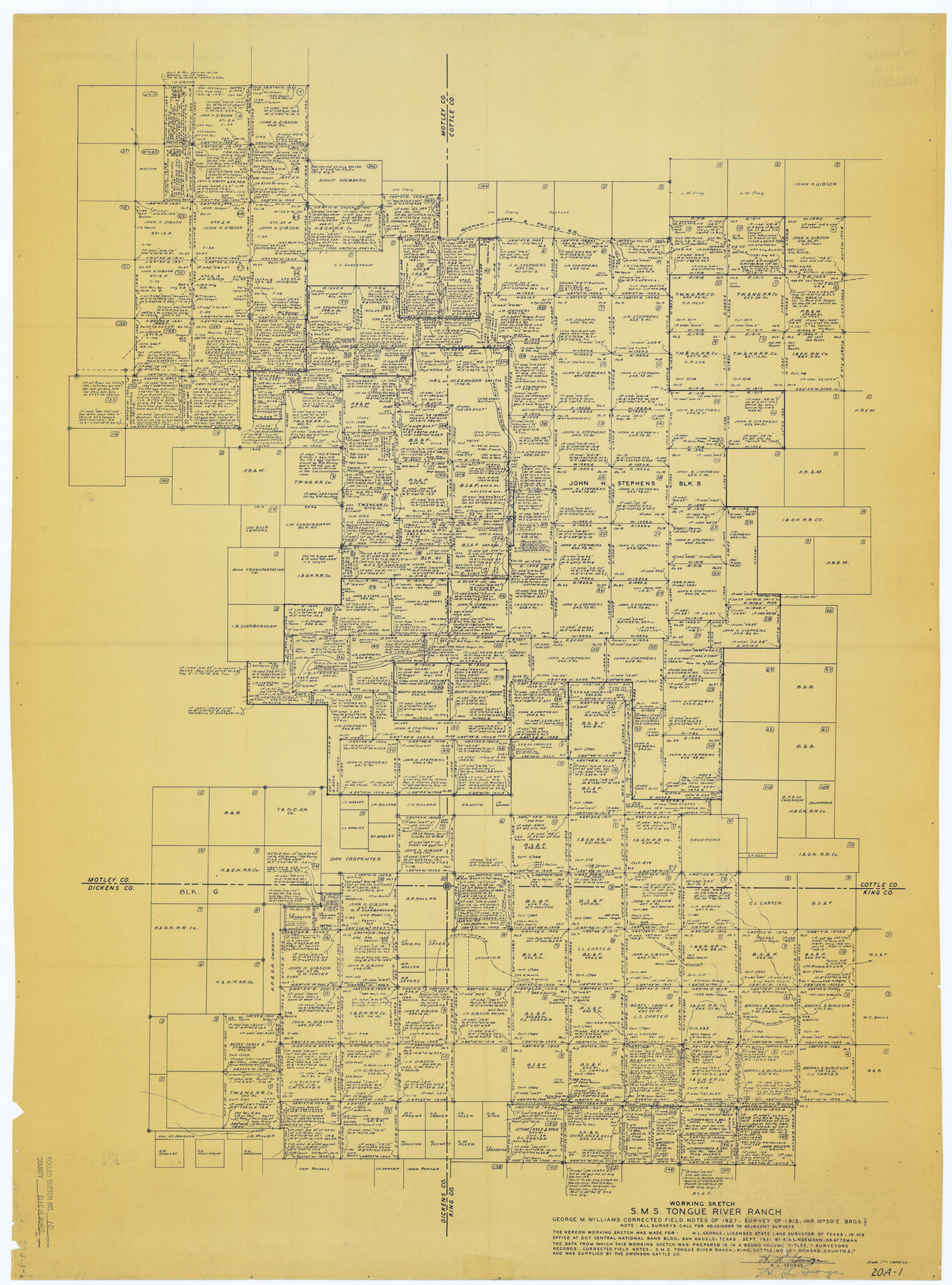
Working Sketch S. M. S. Tongue River Ranch
-
Map/Doc
8789
-
Collection
General Map Collection
-
Object Dates
1951 (Survey Date)
1954/5/15 (File Date)
-
People and Organizations
H.L. George (Surveyor/Engineer)
-
Counties
Dickens King Motley Cottle
-
Subjects
Surveying Rolled Sketch
-
Height x Width
43.0 x 31.9 inches
109.2 x 81.0 cm
-
Medium
blueprint/diazo
-
Scale
1" = 1000 varas
-
Comments
See Dickens County Rolled Sketch 9 (5708) for related sketch and see Dickens County Sketch File 35 (64791) for surveyor’s report.
Related maps
Dickens County Rolled Sketch 9

Print $20.00
- Digital $50.00
Dickens County Rolled Sketch 9
1954
Size 41.0 x 30.3 inches
Map/Doc 5708
Dickens County Sketch File 35

Print $10.00
- Digital $50.00
Dickens County Sketch File 35
1954
Size 11.2 x 8.9 inches
Map/Doc 64791
Part of: General Map Collection
Flight Mission No. DCL-7C, Frame 110, Kenedy County

Print $20.00
- Digital $50.00
Flight Mission No. DCL-7C, Frame 110, Kenedy County
1943
Size 18.5 x 22.3 inches
Map/Doc 86075
Haskell County Rolled Sketch 13

Print $3.00
- Digital $50.00
Haskell County Rolled Sketch 13
1991
Size 11.0 x 17.1 inches
Map/Doc 6171
Rockwall County Working Sketch 2

Print $20.00
- Digital $50.00
Rockwall County Working Sketch 2
1923
Size 20.9 x 16.8 inches
Map/Doc 63594
Coke County Boundary File 3

Print $18.00
- Digital $50.00
Coke County Boundary File 3
Size 8.6 x 4.0 inches
Map/Doc 51584
Trinity County Sketch File 10

Print $8.00
- Digital $50.00
Trinity County Sketch File 10
1858
Size 13.1 x 8.0 inches
Map/Doc 38527

Sutton County Rolled Sketch 62

Print $40.00
- Digital $50.00
Sutton County Rolled Sketch 62
Size 69.8 x 45.2 inches
Map/Doc 9978
Cherokee County Working Sketch 18

Print $40.00
- Digital $50.00
Cherokee County Working Sketch 18
1958
Size 74.6 x 43.6 inches
Map/Doc 67973
Map of Wharton County

Print $20.00
- Digital $50.00
Map of Wharton County
1871
Size 22.3 x 23.6 inches
Map/Doc 4135
Flight Mission No. CUG-3P, Frame 138, Kleberg County

Print $20.00
- Digital $50.00
Flight Mission No. CUG-3P, Frame 138, Kleberg County
1956
Size 18.6 x 22.4 inches
Map/Doc 86273
Map of Kerr County Texas

Print $20.00
- Digital $50.00
Map of Kerr County Texas
1879
Size 20.5 x 28.5 inches
Map/Doc 4575
Flight Mission No. CRE-1R, Frame 121, Jackson County

Print $20.00
- Digital $50.00
Flight Mission No. CRE-1R, Frame 121, Jackson County
1956
Size 16.2 x 16.0 inches
Map/Doc 85332
You may also like
![91655, [Capitol Lands], Twichell Survey Records](https://historictexasmaps.com/wmedia_w700/maps/91655-1.tif.jpg)
Flight Mission No. DQN-1K, Frame 49, Calhoun County

Print $20.00
- Digital $50.00
Flight Mission No. DQN-1K, Frame 49, Calhoun County
1953
Size 18.6 x 22.4 inches
Map/Doc 84149
Fayette County

Print $40.00
- Digital $50.00
Fayette County
1978
Size 43.6 x 56.1 inches
Map/Doc 95496
Mason County Working Sketch 17

Print $20.00
- Digital $50.00
Mason County Working Sketch 17
1983
Size 24.3 x 41.1 inches
Map/Doc 70853
Wichita County Working Sketch 19

Print $20.00
- Digital $50.00
Wichita County Working Sketch 19
1949
Size 18.1 x 30.9 inches
Map/Doc 72529
Flight Mission No. DAH-17M, Frame 26, Orange County

Print $20.00
- Digital $50.00
Flight Mission No. DAH-17M, Frame 26, Orange County
1953
Size 18.3 x 22.3 inches
Map/Doc 86889
Lampasas County Working Sketch 18

Print $20.00
- Digital $50.00
Lampasas County Working Sketch 18
1977
Size 46.1 x 44.0 inches
Map/Doc 70295
Jefferson County Working Sketch 1

Print $20.00
- Digital $50.00
Jefferson County Working Sketch 1
Size 22.7 x 17.5 inches
Map/Doc 66544
Houston County

Print $20.00
- Digital $50.00
Houston County
1877
Size 25.9 x 26.2 inches
Map/Doc 3684
[WWI Topographic Planning Map of the Ardennes department] - Verso
![94130, [WWI Topographic Planning Map of the Ardennes department] - Verso, Non-GLO Digital Images](https://historictexasmaps.com/wmedia_w700/maps/94130-1.tif.jpg)
Print $20.00
[WWI Topographic Planning Map of the Ardennes department] - Verso
1918
Size 35.9 x 20.4 inches
Map/Doc 94130
[St. L. S-W. Ry. of Texas Map of Lufkin Branch in Cherokee County Texas]
![64018, [St. L. S-W. Ry. of Texas Map of Lufkin Branch in Cherokee County Texas], General Map Collection](https://historictexasmaps.com/wmedia_w700/maps/64018.tif.jpg)
Print $40.00
- Digital $50.00
[St. L. S-W. Ry. of Texas Map of Lufkin Branch in Cherokee County Texas]
1912
Size 22.3 x 121.1 inches
Map/Doc 64018
Pecos County Rolled Sketch 159

Print $46.00
- Digital $50.00
Pecos County Rolled Sketch 159
1964
Size 31.9 x 38.3 inches
Map/Doc 7285