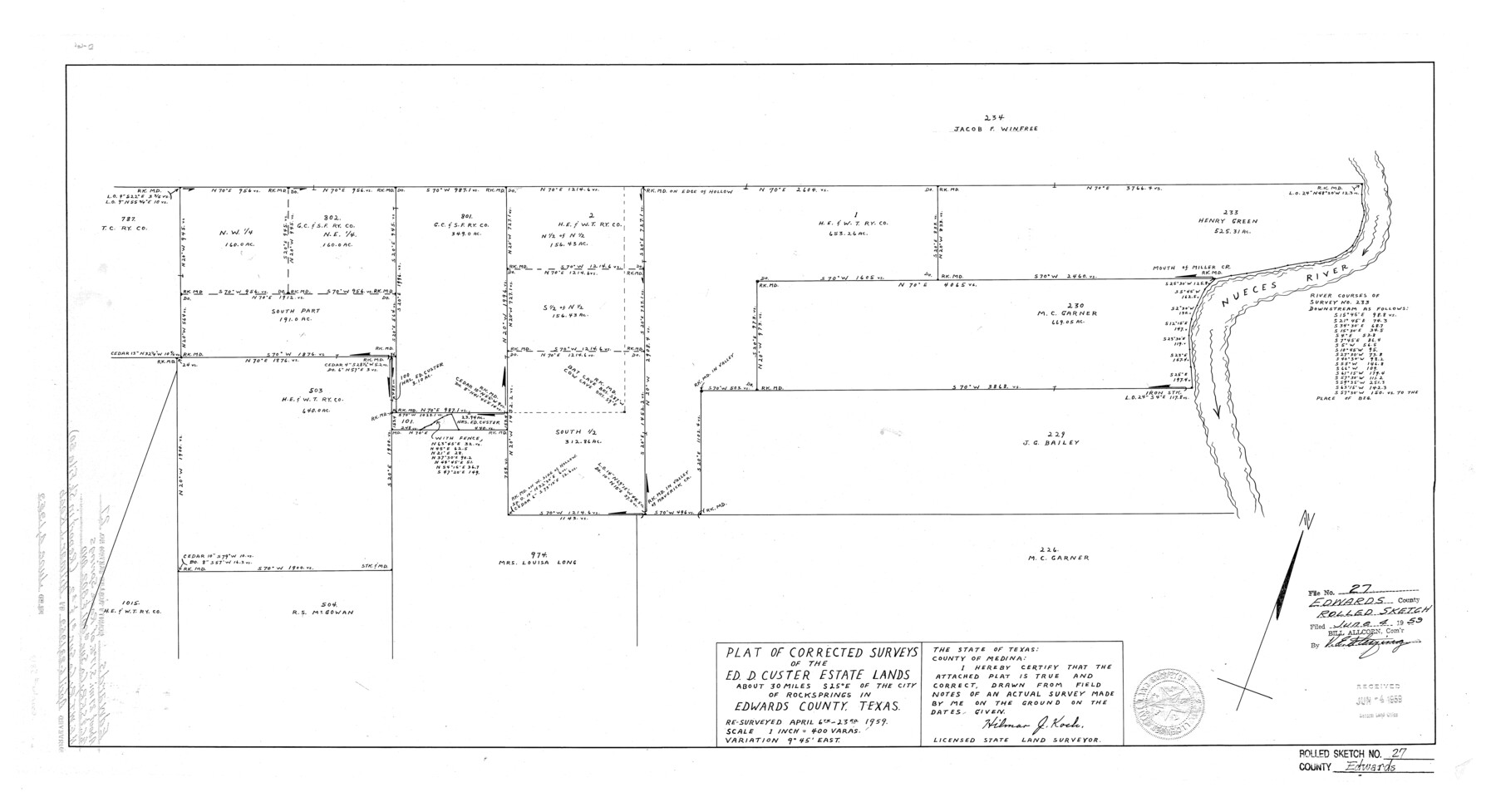
Edwards County Rolled Sketch 27
Plat of corrected surveys of the Ed. D. Custer Estate Lands
-
Map/Doc
5813
-
Collection
General Map Collection
-
Object Dates
1959/4/23 (Creation Date)
1959/6/4 (File Date)
-
People and Organizations
Hilmar J. Koch (Surveyor/Engineer)
-
Counties
Edwards
-
Subjects
Surveying Rolled Sketch
-
Height x Width
18.0 x 33.2 inches
45.7 x 84.3 cm
-
Scale
1" = 400 varas
Part of: General Map Collection
Cherokee County Working Sketch 25

Print $20.00
- Digital $50.00
Cherokee County Working Sketch 25
1972
Size 25.1 x 45.5 inches
Map/Doc 67980
Zavala County Sketch File 23

Print $4.00
- Digital $50.00
Zavala County Sketch File 23
1885
Size 14.4 x 8.8 inches
Map/Doc 41380
Haskell County Rolled Sketch 13

Print $3.00
- Digital $50.00
Haskell County Rolled Sketch 13
1991
Size 11.0 x 17.1 inches
Map/Doc 6171
Sherman County

Print $20.00
- Digital $50.00
Sherman County
1932
Size 39.6 x 36.4 inches
Map/Doc 77422
Kerr County Working Sketch 35

Print $20.00
- Digital $50.00
Kerr County Working Sketch 35
1981
Size 35.2 x 15.5 inches
Map/Doc 70066
Knox County Sketch File 9

Print $4.00
- Digital $50.00
Knox County Sketch File 9
1889
Size 11.1 x 8.8 inches
Map/Doc 29221
Comal County Working Sketch 13

Print $20.00
- Digital $50.00
Comal County Working Sketch 13
1988
Size 32.6 x 21.3 inches
Map/Doc 68179
Dimmit County Working Sketch 57

Print $20.00
- Digital $50.00
Dimmit County Working Sketch 57
2008
Size 26.1 x 31.7 inches
Map/Doc 88847
Randall County Rolled Sketch 9

Print $20.00
- Digital $50.00
Randall County Rolled Sketch 9
Size 47.5 x 35.8 inches
Map/Doc 9808
Copy of Surveyor's Field Book, Morris Browning - In Blocks 7, 5 & 4, I&GNRRCo., Hutchinson and Carson Counties, Texas

Print $2.00
- Digital $50.00
Copy of Surveyor's Field Book, Morris Browning - In Blocks 7, 5 & 4, I&GNRRCo., Hutchinson and Carson Counties, Texas
1888
Size 7.0 x 8.9 inches
Map/Doc 62266
The Texas & Oklahoma Official Railway & Hotel Guide Map

Print $20.00
- Digital $50.00
The Texas & Oklahoma Official Railway & Hotel Guide Map
1917
Size 23.6 x 24.1 inches
Map/Doc 94032
Val Verde County Sketch File 50

Print $8.00
- Digital $50.00
Val Verde County Sketch File 50
1956
Size 11.5 x 8.9 inches
Map/Doc 39316
You may also like
Flight Mission No. DQN-5K, Frame 50, Calhoun County

Print $20.00
- Digital $50.00
Flight Mission No. DQN-5K, Frame 50, Calhoun County
1953
Size 18.5 x 22.3 inches
Map/Doc 84395
Harris County Sketch File 78

Print $32.00
- Digital $50.00
Harris County Sketch File 78
1955
Size 8.7 x 9.0 inches
Map/Doc 25549
Harris County Working Sketch 89

Print $20.00
- Digital $50.00
Harris County Working Sketch 89
1972
Size 37.3 x 39.0 inches
Map/Doc 65981
Kleberg County Aerial Photograph Index Sheet 4

Print $20.00
- Digital $50.00
Kleberg County Aerial Photograph Index Sheet 4
1956
Size 19.3 x 23.3 inches
Map/Doc 83721
Sherman County Sketch File B

Print $6.00
- Digital $50.00
Sherman County Sketch File B
1919
Size 14.4 x 8.8 inches
Map/Doc 36691
Cooke County Boundary File 4

Print $6.00
- Digital $50.00
Cooke County Boundary File 4
Size 8.6 x 11.3 inches
Map/Doc 51855
Lines of Equal Magnetic Declination and of Equal Annual Change in the United States for 1930

Print $20.00
- Digital $50.00
Lines of Equal Magnetic Declination and of Equal Annual Change in the United States for 1930
1930
Size 23.5 x 29.7 inches
Map/Doc 69652
Map of Navisota County

Print $20.00
- Digital $50.00
Map of Navisota County
Size 27.5 x 19.6 inches
Map/Doc 3328
Calhoun County Rolled Sketch 30

Print $20.00
- Digital $50.00
Calhoun County Rolled Sketch 30
1974
Size 18.5 x 27.5 inches
Map/Doc 5488
Webb County Sketch File 25

Print $20.00
- Digital $50.00
Webb County Sketch File 25
1936
Size 18.2 x 30.7 inches
Map/Doc 12639
[Worksheets related to the Wilson Strickland survey and vicinity]
![89714, [Vicinity and related to the Wilson Strickland Survey], Twichell Survey Records](https://historictexasmaps.com/wmedia_w700/maps/89714-1.tif.jpg)
Print $20.00
- Digital $50.00
[Worksheets related to the Wilson Strickland survey and vicinity]
Size 40.9 x 43.1 inches
Map/Doc 89714
Real County Working Sketch 63

Print $20.00
- Digital $50.00
Real County Working Sketch 63
1967
Size 28.8 x 32.3 inches
Map/Doc 71955