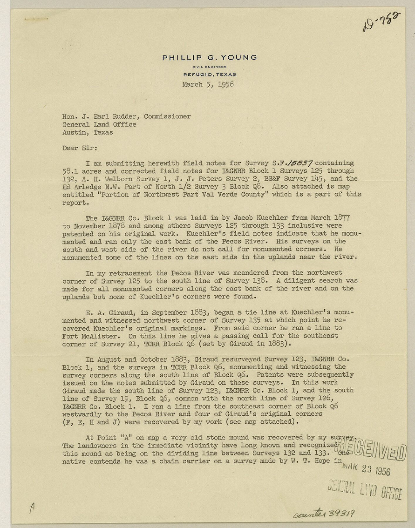
Val Verde County Sketch File 50
[Report of a survey of I. & G. N. R.R. Co. Block 1, sections 125 through 132 and adjoining surveys]
-
Map/Doc
39316
-
Collection
General Map Collection
-
Object Dates
3/5/1956 (Creation Date)
3/23/1956 (File Date)
-
People and Organizations
Phillip G. Young (Surveyor/Engineer)
-
Counties
Val Verde
-
Subjects
Surveying Sketch File
-
Height x Width
11.5 x 8.9 inches
29.2 x 22.6 cm
-
Medium
paper, print
-
Comments
See Val Verde County Rolled Sketch 62 (10081) for sketch and SF-15837
-
Features
Pecos River
Related maps
Val Verde County Rolled Sketch 62

Print $40.00
- Digital $50.00
Val Verde County Rolled Sketch 62
1956
Size 34.6 x 52.1 inches
Map/Doc 10081
Part of: General Map Collection
Flight Mission No. BRE-2P, Frame 71, Nueces County

Print $20.00
- Digital $50.00
Flight Mission No. BRE-2P, Frame 71, Nueces County
1956
Size 18.4 x 22.6 inches
Map/Doc 86766
Menard County Boundary File 9

Print $4.00
- Digital $50.00
Menard County Boundary File 9
Size 9.9 x 8.1 inches
Map/Doc 57094
Rusk County Sketch File 9

Print $4.00
Rusk County Sketch File 9
1849
Size 8.4 x 8.2 inches
Map/Doc 35505
Gonzales County Boundary File 34 (9)

Print $18.00
- Digital $50.00
Gonzales County Boundary File 34 (9)
Size 8.5 x 3.9 inches
Map/Doc 53836
Throckmorton County Boundary File 1

Print $12.00
- Digital $50.00
Throckmorton County Boundary File 1
Size 8.8 x 7.8 inches
Map/Doc 59258
Montgomery Co.

Print $40.00
- Digital $50.00
Montgomery Co.
1943
Size 44.4 x 54.1 inches
Map/Doc 73244
Montgomery County Rolled Sketch 26

Print $40.00
- Digital $50.00
Montgomery County Rolled Sketch 26
Size 50.0 x 65.4 inches
Map/Doc 9535
Map of Texas and Pacific Ry. Company's Surveys in the 80 Mile Reserve

Print $40.00
- Digital $50.00
Map of Texas and Pacific Ry. Company's Surveys in the 80 Mile Reserve
1885
Map/Doc 2241
Mason County Working Sketch 4

Print $20.00
- Digital $50.00
Mason County Working Sketch 4
1932
Size 16.6 x 22.2 inches
Map/Doc 70840
El Paso County Boundary File 22

Print $4.00
- Digital $50.00
El Paso County Boundary File 22
Size 13.6 x 8.6 inches
Map/Doc 53216
Gregg County Rolled Sketch 27

Print $137.00
- Digital $50.00
Gregg County Rolled Sketch 27
1933
Size 10.4 x 15.3 inches
Map/Doc 45625
[Surveys in the Bexar District along the Medina River]
![128, [Surveys in the Bexar District along the Medina River], General Map Collection](https://historictexasmaps.com/wmedia_w700/maps/128.tif.jpg)
Print $20.00
- Digital $50.00
[Surveys in the Bexar District along the Medina River]
1841
Size 23.0 x 16.8 inches
Map/Doc 128
You may also like
Van Zandt County Sketch File 32a

Print $4.00
- Digital $50.00
Van Zandt County Sketch File 32a
1860
Size 12.3 x 8.1 inches
Map/Doc 39467
Val Verde County Sketch File B

Print $28.00
- Digital $50.00
Val Verde County Sketch File B
1897
Size 20.2 x 15.0 inches
Map/Doc 12542
Culberson County Working Sketch 28

Print $40.00
- Digital $50.00
Culberson County Working Sketch 28
1952
Size 51.3 x 38.9 inches
Map/Doc 68481
Flight Mission No. BRE-2P, Frame 46, Nueces County

Print $20.00
- Digital $50.00
Flight Mission No. BRE-2P, Frame 46, Nueces County
1956
Size 18.7 x 22.7 inches
Map/Doc 86748
Flight Mission No. BRE-1P, Frame 35, Nueces County

Print $20.00
- Digital $50.00
Flight Mission No. BRE-1P, Frame 35, Nueces County
1956
Size 18.4 x 22.2 inches
Map/Doc 86631
Live Oak County Sketch File 27

Print $4.00
- Digital $50.00
Live Oak County Sketch File 27
1922
Size 14.3 x 8.7 inches
Map/Doc 30312
Colton's New Map of the State of Texas Compiled from J. DeCordova's large Map

Print $20.00
Colton's New Map of the State of Texas Compiled from J. DeCordova's large Map
1858
Size 17.0 x 26.2 inches
Map/Doc 79736
Tech Town a Subdivision of the Northeast Quarter Section 18, Block B

Print $20.00
- Digital $50.00
Tech Town a Subdivision of the Northeast Quarter Section 18, Block B
Size 17.5 x 21.6 inches
Map/Doc 92792
Flight Mission No. DQN-1K, Frame 145, Calhoun County

Print $20.00
- Digital $50.00
Flight Mission No. DQN-1K, Frame 145, Calhoun County
1953
Size 18.6 x 22.3 inches
Map/Doc 84208
Wichita County Working Sketch 26

Print $20.00
- Digital $50.00
Wichita County Working Sketch 26
1981
Size 13.1 x 21.0 inches
Map/Doc 72536
Zavala County Sketch File 45

Print $4.00
- Digital $50.00
Zavala County Sketch File 45
1923
Size 11.5 x 8.8 inches
Map/Doc 41428
Kimble County Working Sketch 37

Print $20.00
- Digital $50.00
Kimble County Working Sketch 37
1946
Size 34.3 x 20.6 inches
Map/Doc 70105