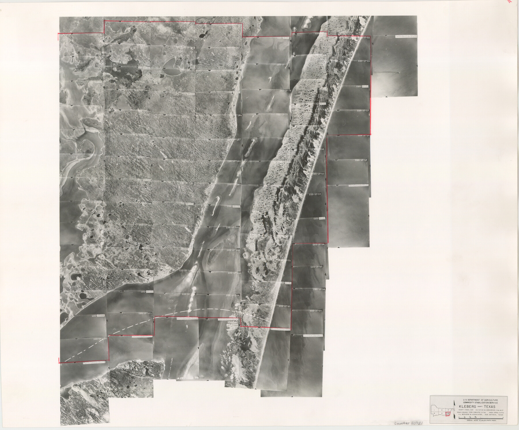
Kleberg County Aerial Photograph Index Sheet 4
Kleberg County Aerial Photograph Index 4
-
Map/Doc
83721
-
Collection
General Map Collection
-
Object Dates
1956/3/27 (Creation Date)
-
People and Organizations
U. S. Department of Agriculture (Publisher)
-
Counties
Kleberg
-
Subjects
Aerial Photograph
-
Height x Width
19.3 x 23.3 inches
49.0 x 59.2 cm
-
Comments
Flying completed March 17, 1956 by V. L. Beavers and Associates of San Antonio, Texas.
Part of: General Map Collection
Cochran County Sketch File 3

Print $4.00
- Digital $50.00
Cochran County Sketch File 3
Size 8.8 x 11.3 inches
Map/Doc 18540
Madison County

Print $20.00
- Digital $50.00
Madison County
1871
Size 15.2 x 20.3 inches
Map/Doc 4587
Township 10 North Range 15 West, North Western District, Louisiana

Print $20.00
- Digital $50.00
Township 10 North Range 15 West, North Western District, Louisiana
1854
Size 19.5 x 24.6 inches
Map/Doc 65871
Flight Mission No. CRK-8P, Frame 105, Refugio County

Print $20.00
- Digital $50.00
Flight Mission No. CRK-8P, Frame 105, Refugio County
1956
Size 18.2 x 22.0 inches
Map/Doc 86966
Eastland County Working Sketch 21

Print $20.00
- Digital $50.00
Eastland County Working Sketch 21
1920
Size 15.4 x 22.7 inches
Map/Doc 68802
Maps of Gulf Intracoastal Waterway, Texas - Sabine River to the Rio Grande and connecting waterways including ship channels

Print $20.00
- Digital $50.00
Maps of Gulf Intracoastal Waterway, Texas - Sabine River to the Rio Grande and connecting waterways including ship channels
1966
Size 14.6 x 22.3 inches
Map/Doc 61957
Trinity County Sketch File 13

Print $6.00
- Digital $50.00
Trinity County Sketch File 13
1857
Size 5.0 x 6.3 inches
Map/Doc 38537
Montgomery County Sketch File 37

Print $6.00
- Digital $50.00
Montgomery County Sketch File 37
Size 12.6 x 8.2 inches
Map/Doc 31916
Somervell County Working Sketch 4

Print $20.00
- Digital $50.00
Somervell County Working Sketch 4
1975
Size 38.3 x 29.7 inches
Map/Doc 63908
Coke County Rolled Sketch 1

Print $20.00
- Digital $50.00
Coke County Rolled Sketch 1
1943
Size 26.9 x 21.6 inches
Map/Doc 5503
Flight Mission No. BRE-2P, Frame 35, Nueces County

Print $20.00
- Digital $50.00
Flight Mission No. BRE-2P, Frame 35, Nueces County
1956
Size 18.7 x 22.8 inches
Map/Doc 86737
Hardin County Rolled Sketch 13

Print $20.00
- Digital $50.00
Hardin County Rolled Sketch 13
Size 36.0 x 42.3 inches
Map/Doc 9187
You may also like
Martin County Boundary File 3

Print $2.00
- Digital $50.00
Martin County Boundary File 3
Size 7.1 x 11.3 inches
Map/Doc 56781
[Sketch for Mineral Application 24072, San Jacinto River]
![65589, [Sketch for Mineral Application 24072, San Jacinto River], General Map Collection](https://historictexasmaps.com/wmedia_w700/maps/65589.tif.jpg)
Print $20.00
- Digital $50.00
[Sketch for Mineral Application 24072, San Jacinto River]
1929
Size 29.6 x 14.7 inches
Map/Doc 65589
[T. & P. Block 44, Township 1S]
![90825, [T. & P. Block 44, Township 1S], Twichell Survey Records](https://historictexasmaps.com/wmedia_w700/maps/90825-2.tif.jpg)
Print $20.00
- Digital $50.00
[T. & P. Block 44, Township 1S]
Size 17.9 x 23.3 inches
Map/Doc 90825

Map of Lands surveyed for the Deaf & Dumb Asylum on the head waters of the Leon River

Print $20.00
- Digital $50.00
Map of Lands surveyed for the Deaf & Dumb Asylum on the head waters of the Leon River
1857
Size 13.3 x 17.1 inches
Map/Doc 2209
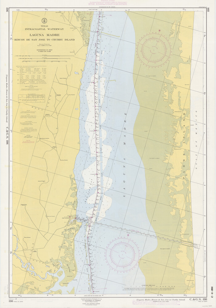
Texas Intracoastal Waterway - Laguna Madre - Rincon de San Jose to Chubby Island
Print $20.00
- Digital $50.00
Texas Intracoastal Waterway - Laguna Madre - Rincon de San Jose to Chubby Island
1961
Size 38.0 x 26.7 inches
Map/Doc 73514
Map Showing Position of Surveys Represented Hereon

Print $40.00
- Digital $50.00
Map Showing Position of Surveys Represented Hereon
Size 39.6 x 57.9 inches
Map/Doc 75810
Map of the River Sabine from Logan's Ferry to 32nd degree of North Latitude

Print $20.00
- Digital $50.00
Map of the River Sabine from Logan's Ferry to 32nd degree of North Latitude
Size 22.1 x 28.6 inches
Map/Doc 94002
Presidio County Rolled Sketch 65

Print $20.00
- Digital $50.00
Presidio County Rolled Sketch 65
Size 23.1 x 28.3 inches
Map/Doc 7356
Smith County Sketch File 15

Print $8.00
- Digital $50.00
Smith County Sketch File 15
1948
Size 11.2 x 8.8 inches
Map/Doc 36777
Upshur County Working Sketch 15, revised

Print $20.00
- Digital $50.00
Upshur County Working Sketch 15, revised
1996
Size 43.3 x 37.4 inches
Map/Doc 78217
Motley County Sketch File 2 (S)

Print $20.00
- Digital $50.00
Motley County Sketch File 2 (S)
Size 31.1 x 25.1 inches
Map/Doc 42133