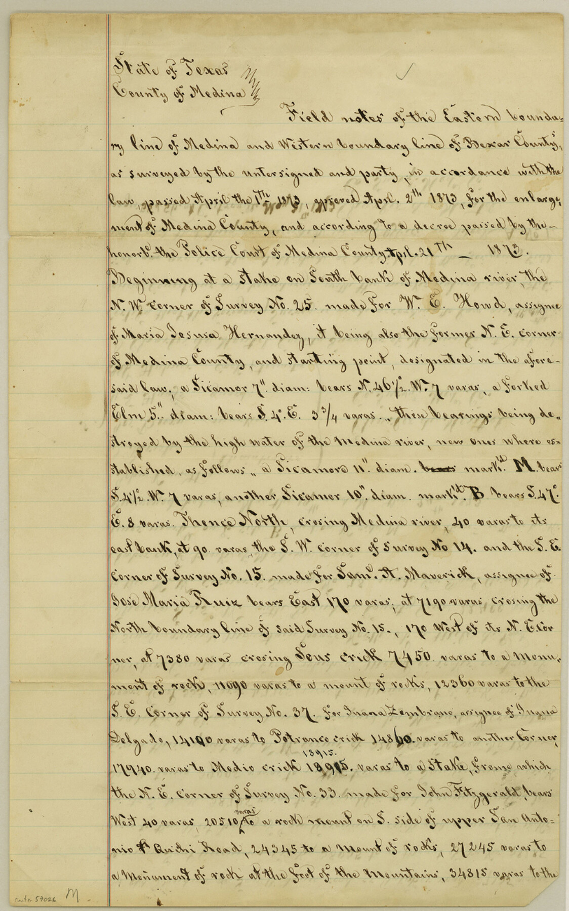
Medina County Boundary File 2
Field notes of Meda [sp.], Bexar & Bandera Co. lines
-
Map/Doc
57026
-
Collection
General Map Collection
-
Counties
Medina
-
Subjects
County Boundaries
-
Height x Width
13.0 x 8.1 inches
33.0 x 20.6 cm
Part of: General Map Collection
Stonewall County Working Sketch 26

Print $20.00
- Digital $50.00
Stonewall County Working Sketch 26
1973
Size 27.0 x 17.9 inches
Map/Doc 62333
Liberty County Working Sketch 6

Print $20.00
- Digital $50.00
Liberty County Working Sketch 6
1903
Size 17.2 x 19.5 inches
Map/Doc 70465
Brewster County Rolled Sketch 72

Print $20.00
- Digital $50.00
Brewster County Rolled Sketch 72
1941
Size 42.0 x 28.4 inches
Map/Doc 5238
Tyler County Sketch File 21

Print $4.00
- Digital $50.00
Tyler County Sketch File 21
1906
Size 10.9 x 9.1 inches
Map/Doc 38677
Kent County Boundary File 4

Print $20.00
- Digital $50.00
Kent County Boundary File 4
Size 8.8 x 4.6 inches
Map/Doc 55828
McMullen County Sketch File 46

Print $6.00
- Digital $50.00
McMullen County Sketch File 46
1943
Size 14.3 x 8.7 inches
Map/Doc 31434
Harris County Rolled Sketch 33

Print $20.00
- Digital $50.00
Harris County Rolled Sketch 33
1912
Size 26.0 x 34.5 inches
Map/Doc 6097
The Spot Map of San Antonio including a classified directory showing location of postal zones, points of interest, places of business - and how to get there

Print $20.00
- Digital $50.00
The Spot Map of San Antonio including a classified directory showing location of postal zones, points of interest, places of business - and how to get there
1941
Size 21.2 x 28.2 inches
Map/Doc 95953
Sutton County Sketch File 57

Print $24.00
- Digital $50.00
Sutton County Sketch File 57
1961
Size 11.2 x 8.8 inches
Map/Doc 37542
Navarro County Sketch File 7

Print $4.00
- Digital $50.00
Navarro County Sketch File 7
1854
Size 12.2 x 8.0 inches
Map/Doc 32313
Webb County Sketch File 7

Print $40.00
- Digital $50.00
Webb County Sketch File 7
1877
Size 13.7 x 14.3 inches
Map/Doc 39739
Upton County Rolled Sketch 10

Print $20.00
- Digital $50.00
Upton County Rolled Sketch 10
1911
Size 41.2 x 43.0 inches
Map/Doc 10035
You may also like
Map of Goliad County Texas

Print $20.00
- Digital $50.00
Map of Goliad County Texas
1879
Size 19.2 x 21.3 inches
Map/Doc 4547
Outer Continental Shelf Leasing Maps (Louisiana Offshore Operations)

Print $20.00
- Digital $50.00
Outer Continental Shelf Leasing Maps (Louisiana Offshore Operations)
1955
Size 17.2 x 9.4 inches
Map/Doc 76081
Hood County Working Sketch 11

Print $20.00
- Digital $50.00
Hood County Working Sketch 11
1976
Size 19.7 x 25.2 inches
Map/Doc 66205
Presidio County Sketch File 44

Print $15.00
- Digital $50.00
Presidio County Sketch File 44
1913
Size 11.1 x 9.5 inches
Map/Doc 34525
Shackelford County, Map of SE part of Block No. 1, Eastern Texas RR. Co. Survey

Print $20.00
- Digital $50.00
Shackelford County, Map of SE part of Block No. 1, Eastern Texas RR. Co. Survey
Size 19.1 x 19.5 inches
Map/Doc 91899
Bexar County Working Sketch 16

Print $20.00
- Digital $50.00
Bexar County Working Sketch 16
1978
Size 23.0 x 44.5 inches
Map/Doc 67332
Loving County Working Sketch 23

Print $20.00
- Digital $50.00
Loving County Working Sketch 23
1952
Size 15.1 x 31.5 inches
Map/Doc 70657
General Highway Map, Moore County, Texas

Print $20.00
General Highway Map, Moore County, Texas
1940
Size 18.4 x 24.8 inches
Map/Doc 79203
[I. & G. N. Sections 11, 12, and 13]
![91039, [I. & G. N. Sections 11, 12, and 13], Twichell Survey Records](https://historictexasmaps.com/wmedia_w700/maps/91039-1.tif.jpg)
Print $20.00
- Digital $50.00
[I. & G. N. Sections 11, 12, and 13]
Size 24.7 x 15.6 inches
Map/Doc 91039
Refugio County Working Sketch 16

Print $20.00
- Digital $50.00
Refugio County Working Sketch 16
1965
Size 34.0 x 31.8 inches
Map/Doc 63525
Sutton County Working Sketch 52

Print $20.00
- Digital $50.00
Sutton County Working Sketch 52
1956
Size 19.2 x 31.4 inches
Map/Doc 62395
Flight Mission No. DAG-17K, Frame 76, Matagorda County

Print $20.00
- Digital $50.00
Flight Mission No. DAG-17K, Frame 76, Matagorda County
1952
Size 16.6 x 16.6 inches
Map/Doc 86335