Sutton County Sketch File 57
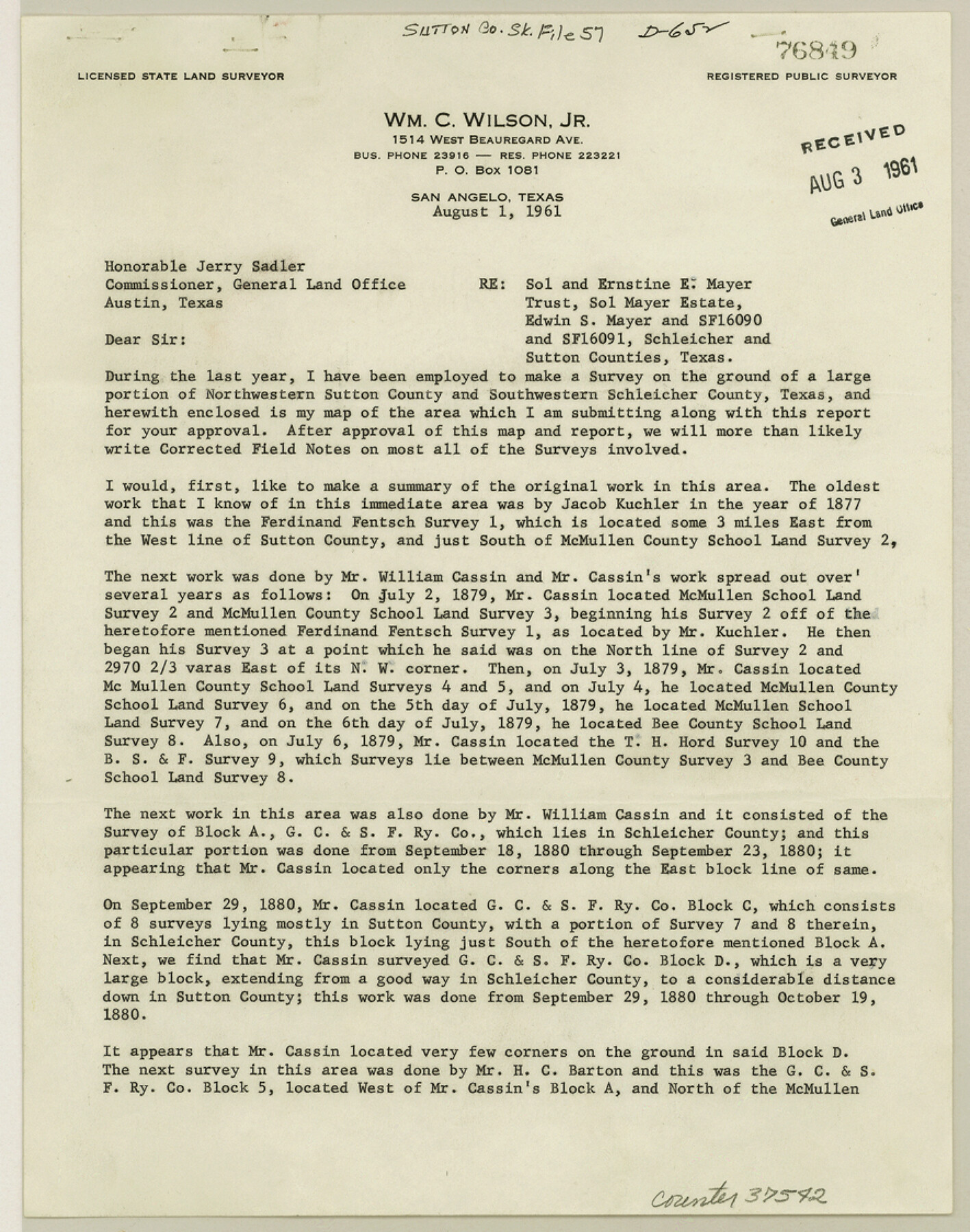
[Report of resurvey of Mayer Estate in Sutton and Schleicher Counties]
-
Map/Doc
37542
-
Collection
General Map Collection
-
Object Dates
1909/3/5 (Survey Date)
1961/8/3 (File Date)
1912/1/15 (File Date)
1947/4/16 (Survey Date)
1960 (Survey Date)
1959 (Survey Date)
1956 (Survey Date)
1952 (Survey Date)
1952 (Survey Date)
1948/9/29 (Survey Date)
1926/8/7 (Survey Date)
1947 (Survey Date)
1946 (Survey Date)
1894/1/22 (Survey Date)
1909/10/9 (Survey Date)
1961/8/1 (Creation Date)
1907/7/17 (Survey Date)
1906 (Survey Date)
1888/4/3 (Survey Date)
1881/1/8 (Survey Date)
1890/11/26 (Survey Date)
1881 (Survey Date)
1882 (Survey Date)
1880/8/19 (Survey Date)
1880/9/23 (Survey Date)
1879/7/6 (Survey Date)
1877 (Survey Date)
1961/8/1 (Correspondence Date)
1961/8/3 (File Date)
-
People and Organizations
James P. Dodd (Surveyor/Engineer)
Wm. C. Wilson, Jr. (Surveyor/Engineer)
Jacob Kuchler [sic] (Surveyor/Engineer)
William Cassin (Surveyor/Engineer)
H.C. Barton (Surveyor/Engineer)
S.A. Thompson (Surveyor/Engineer)
W.H. Bonnell (Surveyor/Engineer)
J. Campbell (Surveyor/Engineer)
J. McNichol (Surveyor/Engineer)
H.M. Garden (Surveyor/Engineer)
James K. Avera (Surveyor/Engineer)
G.D. Hines (Surveyor/Engineer)
J.A. Conklin (Surveyor/Engineer)
John P. Pool (Surveyor/Engineer)
Clifford C. Cool (Surveyor/Engineer)
E.S. Mayer (Draftsman)
Edgar S. Saunders (Draftsman)
-
Counties
Sutton Schleicher Crockett
-
Subjects
Surveying Sketch File
-
Height x Width
11.2 x 8.8 inches
28.5 x 22.4 cm
-
Medium
paper, print
-
Comments
See Sutton County Rolled Sketch 59 (9977) for sketch.
Related maps
Sutton County Rolled Sketch 59

Print $40.00
- Digital $50.00
Sutton County Rolled Sketch 59
1960
Size 86.1 x 42.5 inches
Map/Doc 9977
Part of: General Map Collection
Montague County Sketch File 22

Print $20.00
- Digital $50.00
Montague County Sketch File 22
1927
Size 27.7 x 20.1 inches
Map/Doc 12107

Flight Mission No. DAG-18K, Frame 189, Matagorda County

Print $20.00
- Digital $50.00
Flight Mission No. DAG-18K, Frame 189, Matagorda County
1952
Size 18.5 x 22.3 inches
Map/Doc 86381
San Jacinto County Sketch File 13a

Print $6.00
San Jacinto County Sketch File 13a
Size 8.2 x 13.0 inches
Map/Doc 35725
Laguna Madre, Texas from Triangulation Station Singer to Latitude 26° 20'

Print $40.00
- Digital $50.00
Laguna Madre, Texas from Triangulation Station Singer to Latitude 26° 20'
1880
Size 31.9 x 53.4 inches
Map/Doc 73493

Lee County Working Sketch 5

Print $20.00
- Digital $50.00
Lee County Working Sketch 5
1975
Size 38.5 x 36.2 inches
Map/Doc 70384
Belton and Stillhouse Hollow Reservoirs (Verso)

Belton and Stillhouse Hollow Reservoirs (Verso)
1972
Size 29.3 x 22.7 inches
Map/Doc 94173
Montague County Sketch File 5

Print $20.00
- Digital $50.00
Montague County Sketch File 5
1855
Size 13.1 x 20.1 inches
Map/Doc 12105
Flight Mission No. BRA-7M, Frame 129, Jefferson County

Print $20.00
- Digital $50.00
Flight Mission No. BRA-7M, Frame 129, Jefferson County
1953
Size 16.3 x 16.0 inches
Map/Doc 85523
Morris County Rolled Sketch 2A

Print $20.00
- Digital $50.00
Morris County Rolled Sketch 2A
Size 24.0 x 18.7 inches
Map/Doc 10256
Flight Mission No. BRA-8M, Frame 148, Jefferson County

Print $20.00
- Digital $50.00
Flight Mission No. BRA-8M, Frame 148, Jefferson County
1953
Size 18.8 x 22.5 inches
Map/Doc 85640
You may also like
Controlled Mosaic by Jack Amman Photogrammetric Engineers, Inc - Sheet 26

Print $20.00
- Digital $50.00
Controlled Mosaic by Jack Amman Photogrammetric Engineers, Inc - Sheet 26
1954
Size 20.0 x 24.0 inches
Map/Doc 83477
Hutchinson County Rolled Sketch 10

Print $20.00
- Digital $50.00
Hutchinson County Rolled Sketch 10
Size 33.6 x 29.7 inches
Map/Doc 6281
Fort Bend County Sketch File 17 1/2

Print $52.00
- Digital $50.00
Fort Bend County Sketch File 17 1/2
1896
Size 11.2 x 8.7 inches
Map/Doc 22934
Real County Sketch File 18

Print $28.00
- Digital $50.00
Real County Sketch File 18
1964
Size 14.3 x 8.9 inches
Map/Doc 35076
Young County Working Sketch Graphic Index

Print $20.00
- Digital $50.00
Young County Working Sketch Graphic Index
1941
Size 44.1 x 38.4 inches
Map/Doc 76748
Duval County Rolled Sketch EF

Print $20.00
- Digital $50.00
Duval County Rolled Sketch EF
1934
Size 26.8 x 35.0 inches
Map/Doc 5766
Polk County Texas

Print $20.00
- Digital $50.00
Polk County Texas
1897
Size 27.1 x 21.0 inches
Map/Doc 3956
Zapata County Working Sketch 2

Print $20.00
- Digital $50.00
Zapata County Working Sketch 2
1930
Size 26.0 x 20.3 inches
Map/Doc 62053
Coleman County Sketch File 16

Print $4.00
- Digital $50.00
Coleman County Sketch File 16
1849
Size 9.6 x 8.3 inches
Map/Doc 18683
Ward County Rolled Sketch 27

Print $20.00
- Digital $50.00
Ward County Rolled Sketch 27
1982
Size 22.7 x 16.5 inches
Map/Doc 8166
Lamb County Sketch File 1 and 1a

Print $30.00
- Digital $50.00
Lamb County Sketch File 1 and 1a
Size 8.7 x 7.6 inches
Map/Doc 29337
Flight Mission No. DQN-2K, Frame 1, Calhoun County

Print $20.00
- Digital $50.00
Flight Mission No. DQN-2K, Frame 1, Calhoun County
1953
Size 18.5 x 22.2 inches
Map/Doc 84218