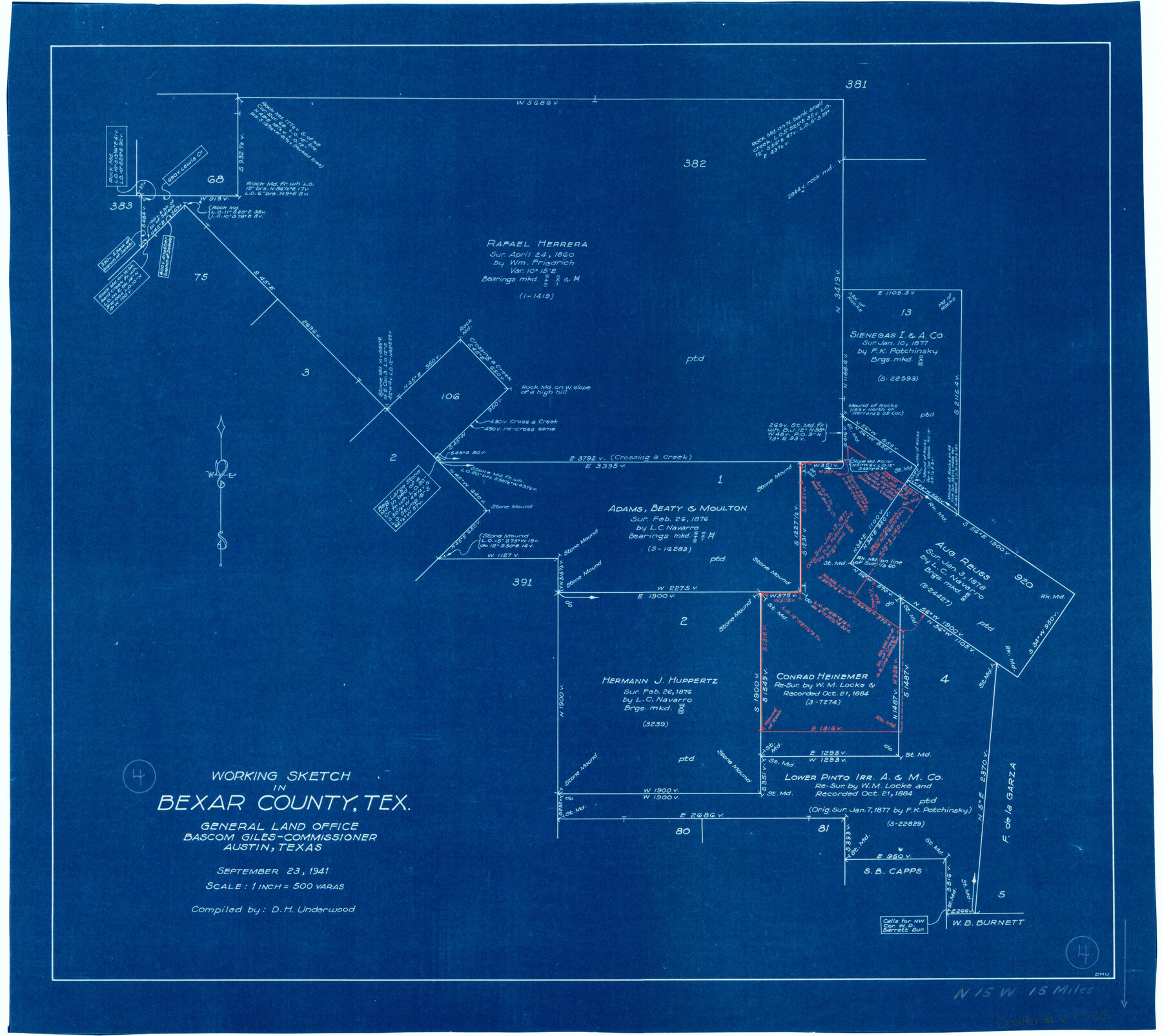
Bexar County Working Sketch 4
-
Map/Doc
67320
-
Collection
General Map Collection
-
Object Dates
9/23/1941 (Creation Date)
-
People and Organizations
Dorothy H. Underwood (Compiler)
Bascom Giles (GLO Commissioner)
-
Counties
Bexar
-
Subjects
Surveying Working Sketch
-
Height x Width
19.4 x 21.7 inches
49.3 x 55.1 cm
-
Scale
1" = 500 varas
-
Comments
Surveys located about 15 miles North 15 degrees West of San Antonio, Texas.
Part of: General Map Collection
Castro County Working Sketch 1

Print $20.00
- Digital $50.00
Castro County Working Sketch 1
Size 22.8 x 17.7 inches
Map/Doc 67896
Bowie County Working Sketch 29

Print $20.00
- Digital $50.00
Bowie County Working Sketch 29
1991
Size 36.9 x 47.7 inches
Map/Doc 67433
Neches River, Box Creek Sheet Cross Section

Print $6.00
- Digital $50.00
Neches River, Box Creek Sheet Cross Section
1940
Size 37.0 x 18.8 inches
Map/Doc 65079
Castro County Sketch File 12

Print $10.00
- Digital $50.00
Castro County Sketch File 12
1910
Size 11.1 x 8.6 inches
Map/Doc 17505
Flight Mission No. DQN-1K, Frame 133, Calhoun County

Print $20.00
- Digital $50.00
Flight Mission No. DQN-1K, Frame 133, Calhoun County
1953
Size 18.6 x 22.4 inches
Map/Doc 84196
Edwards County Sketch File 38

Print $22.00
- Digital $50.00
Edwards County Sketch File 38
1937
Size 11.2 x 8.6 inches
Map/Doc 21773
![94181, San Antonio [Recto], General Map Collection](https://historictexasmaps.com/wmedia_w700/maps/94181.tif.jpg)

Tarrant County Sketch File 10

Print $8.00
- Digital $50.00
Tarrant County Sketch File 10
1859
Size 12.9 x 8.4 inches
Map/Doc 37694
Dickens County Working Sketch 12

Print $20.00
- Digital $50.00
Dickens County Working Sketch 12
1978
Size 28.3 x 28.9 inches
Map/Doc 68660
Fort Bend County Sketch File 3

Print $4.00
- Digital $50.00
Fort Bend County Sketch File 3
Size 12.8 x 8.1 inches
Map/Doc 22880
Flight Mission No. CLL-4N, Frame 33, Willacy County

Print $20.00
- Digital $50.00
Flight Mission No. CLL-4N, Frame 33, Willacy County
1954
Size 18.3 x 22.0 inches
Map/Doc 87106
You may also like
Mapa de los Estados Unidos de Méjico, Segun lo organizado y definido por las varias actas del Congreso de dicha Republica: y construido por las mejores autoridades

Print $20.00
Mapa de los Estados Unidos de Méjico, Segun lo organizado y definido por las varias actas del Congreso de dicha Republica: y construido por las mejores autoridades
1828
Size 29.3 x 41.6 inches
Map/Doc 76217
Dallas County Boundary File 4

Print $38.00
- Digital $50.00
Dallas County Boundary File 4
Size 8.9 x 3.9 inches
Map/Doc 52123
Angelina County Working Sketch 9

Print $20.00
- Digital $50.00
Angelina County Working Sketch 9
1924
Size 28.5 x 28.5 inches
Map/Doc 67090
Intracoastal Waterway in Texas - Corpus Christi to Point Isabel including Arroyo Colorado to Mo. Pac. R.R. Bridge Near Harlingen

Print $20.00
- Digital $50.00
Intracoastal Waterway in Texas - Corpus Christi to Point Isabel including Arroyo Colorado to Mo. Pac. R.R. Bridge Near Harlingen
1933
Size 27.7 x 41.0 inches
Map/Doc 61857
El Paso County Working Sketch 28

Print $20.00
- Digital $50.00
El Paso County Working Sketch 28
1966
Size 24.0 x 31.5 inches
Map/Doc 69050
Uvalde County Rolled Sketch 16

Print $20.00
- Digital $50.00
Uvalde County Rolled Sketch 16
Size 36.6 x 25.1 inches
Map/Doc 8100
Flight Mission No. BRE-1P, Frame 79, Nueces County

Print $20.00
- Digital $50.00
Flight Mission No. BRE-1P, Frame 79, Nueces County
1956
Size 18.4 x 22.2 inches
Map/Doc 86661
Brewster County Rolled Sketch 96

Print $20.00
- Digital $50.00
Brewster County Rolled Sketch 96
1951
Size 21.7 x 33.7 inches
Map/Doc 5253
Outer Continental Shelf Leasing Maps (Texas Offshore Operations)

Print $20.00
- Digital $50.00
Outer Continental Shelf Leasing Maps (Texas Offshore Operations)
1954
Size 14.6 x 15.6 inches
Map/Doc 75836
Flight Mission No. DCL-4C, Frame 123, Kenedy County

Print $20.00
- Digital $50.00
Flight Mission No. DCL-4C, Frame 123, Kenedy County
1943
Size 18.6 x 22.3 inches
Map/Doc 85822
Texas compiled from the latest and best authorities

Print $20.00
- Digital $50.00
Texas compiled from the latest and best authorities
1842
Size 11.8 x 14.0 inches
Map/Doc 93864
Flight Mission No. CGI-4N, Frame 158, Cameron County

Print $20.00
- Digital $50.00
Flight Mission No. CGI-4N, Frame 158, Cameron County
1955
Size 18.5 x 22.2 inches
Map/Doc 84666