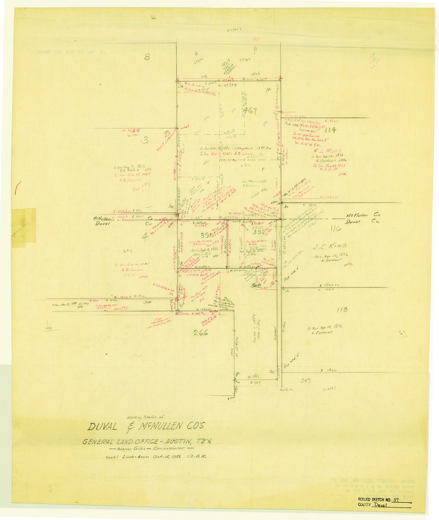
Duval County Rolled Sketch 37
Working Sketch of Duval & McMullen Cos.
-
Map/Doc
5753
-
Collection
General Map Collection
-
Object Dates
1952/10/15 (Creation Date)
-
Counties
Duval McMullen
-
Subjects
Surveying Rolled Sketch
-
Height x Width
29.2 x 24.6 inches
74.2 x 62.5 cm
-
Medium
paper, manuscript
-
Scale
1" = 400 varas
Part of: General Map Collection
Flight Mission No. DAH-9M, Frame 202, Orange County

Print $20.00
- Digital $50.00
Flight Mission No. DAH-9M, Frame 202, Orange County
1953
Size 18.5 x 22.6 inches
Map/Doc 86870
Flight Mission No. DAG-24K, Frame 36, Matagorda County

Print $20.00
- Digital $50.00
Flight Mission No. DAG-24K, Frame 36, Matagorda County
1953
Size 18.5 x 22.2 inches
Map/Doc 86523
Treaty to Resolve Pending Boundary Differences and Maintain the Rio Grande and Colorado River as the International Boundary Between the United States of American and Mexico

Print $20.00
- Digital $50.00
Treaty to Resolve Pending Boundary Differences and Maintain the Rio Grande and Colorado River as the International Boundary Between the United States of American and Mexico
1970
Size 11.1 x 35.3 inches
Map/Doc 83107
Liberty County Working Sketch 24

Print $20.00
- Digital $50.00
Liberty County Working Sketch 24
1941
Size 19.0 x 14.0 inches
Map/Doc 70483
Sabine and Neches Rivers

Print $20.00
- Digital $50.00
Sabine and Neches Rivers
1976
Size 19.8 x 44.9 inches
Map/Doc 69819
Maps of Gulf Intracoastal Waterway, Texas - Sabine River to the Rio Grande and connecting waterways including ship channels

Print $20.00
- Digital $50.00
Maps of Gulf Intracoastal Waterway, Texas - Sabine River to the Rio Grande and connecting waterways including ship channels
1966
Size 14.5 x 21.2 inches
Map/Doc 61989
Cooke County Working Sketch 12

Print $20.00
- Digital $50.00
Cooke County Working Sketch 12
1944
Size 25.2 x 23.0 inches
Map/Doc 68249
[Galveston, Harrisburg & San Antonio through El Paso County]
![64007, [Galveston, Harrisburg & San Antonio through El Paso County], General Map Collection](https://historictexasmaps.com/wmedia_w700/maps/64007.tif.jpg)
Print $20.00
- Digital $50.00
[Galveston, Harrisburg & San Antonio through El Paso County]
1906
Size 13.4 x 33.9 inches
Map/Doc 64007
South Part Presidio County

Print $20.00
- Digital $50.00
South Part Presidio County
1975
Size 31.6 x 37.2 inches
Map/Doc 77400
Cass County Sketch File 5 and 5a

Print $6.00
- Digital $50.00
Cass County Sketch File 5 and 5a
1851
Size 2.8 x 5.1 inches
Map/Doc 17401
Sketch K Showing the Progress of the Survey of the Columbia River, Oregon

Print $20.00
- Digital $50.00
Sketch K Showing the Progress of the Survey of the Columbia River, Oregon
1852
Size 9.8 x 12.7 inches
Map/Doc 97237
Flight Mission No. DQN-1K, Frame 137, Calhoun County

Print $20.00
- Digital $50.00
Flight Mission No. DQN-1K, Frame 137, Calhoun County
1953
Size 18.5 x 22.2 inches
Map/Doc 84200
You may also like
[Area around R. H. Hibbett and Geo. W. Lawrence surveys on Elm Fork of the Brazos River]
![90861, [Area around R. H. Hibbett and Geo. W. Lawrence surveys on Elm Fork of the Brazos River], Twichell Survey Records](https://historictexasmaps.com/wmedia_w700/maps/90861-2.tif.jpg)
Print $20.00
- Digital $50.00
[Area around R. H. Hibbett and Geo. W. Lawrence surveys on Elm Fork of the Brazos River]
1901
Size 23.6 x 32.4 inches
Map/Doc 90861
Flight Mission No. BRA-7M, Frame 151, Jefferson County

Print $20.00
- Digital $50.00
Flight Mission No. BRA-7M, Frame 151, Jefferson County
1953
Size 18.7 x 22.6 inches
Map/Doc 85545

San Jacinto County Working Sketch 11

Print $20.00
- Digital $50.00
San Jacinto County Working Sketch 11
1935
Size 40.1 x 40.0 inches
Map/Doc 63724
The Land Offices. No. 4, Nacogdoches, December 22, 1836

Print $20.00
The Land Offices. No. 4, Nacogdoches, December 22, 1836
2020
Size 14.8 x 21.7 inches
Map/Doc 96417
Reeves County Working Sketch 5

Print $20.00
- Digital $50.00
Reeves County Working Sketch 5
1938
Size 38.0 x 32.4 inches
Map/Doc 63448
Kaufman County Boundary File 1a

Print $8.00
- Digital $50.00
Kaufman County Boundary File 1a
Size 14.1 x 8.6 inches
Map/Doc 55907
Sketch B Showing the progress of Section No. 2

Print $20.00
- Digital $50.00
Sketch B Showing the progress of Section No. 2
1844
Size 25.3 x 27.7 inches
Map/Doc 97204
Gillespie County Sketch File 4

Print $4.00
- Digital $50.00
Gillespie County Sketch File 4
1860
Size 12.7 x 8.2 inches
Map/Doc 24135

Nueces County Sketch File 31

Print $8.00
- Digital $50.00
Nueces County Sketch File 31
1907
Size 14.1 x 8.6 inches
Map/Doc 32601
Crockett County Sketch File 94

Print $6.00
- Digital $50.00
Crockett County Sketch File 94
1940
Size 9.2 x 12.3 inches
Map/Doc 19950