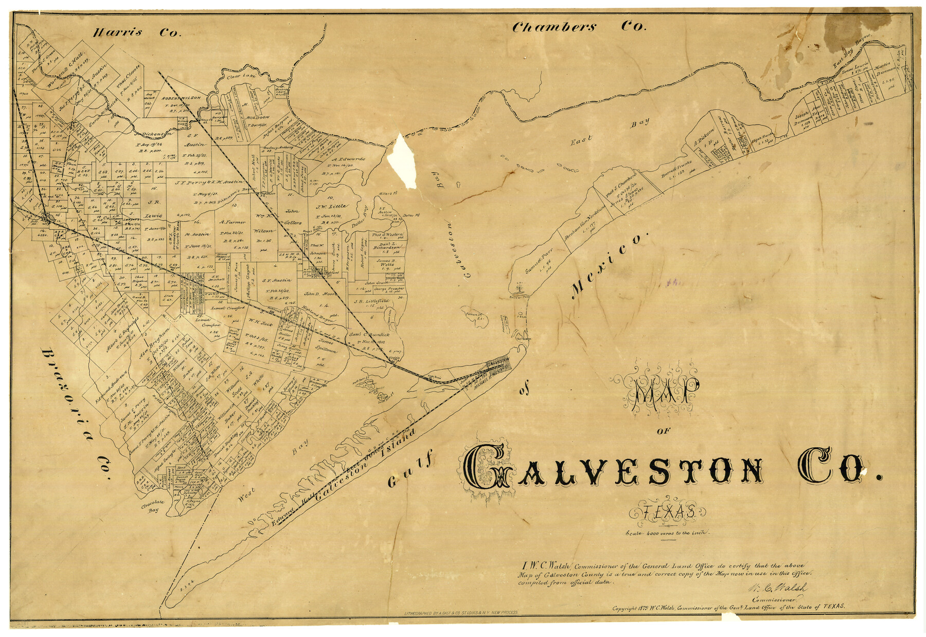
Map of Galveston County, Texas
-
Map/Doc
546
-
Collection
Maddox Collection
-
Object Dates
1879 (Creation Date)
1879 (Copyright Date)
-
People and Organizations
General Land Office (Publisher)
W.C. Walsh (GLO Commissioner)
August Gast & Co. (Lithographer)
-
Counties
Galveston
-
Subjects
County
-
Height x Width
18.3 x 26.6 inches
46.5 x 67.6 cm
-
Medium
paper, etching/engraving/lithograph
-
Scale
1:4000
-
Comments
Conservation funded in 2001 with donation from Frost Bank
-
Features
Galveston
Hitchcock
Highland Bayou
Hall
Virginia Point
GC&SF
North Deer Island
Swan Lake
Fort Reserve
Pelican Spit
Highland Station
Gulf of Mexico
Eagle Grove
GB&C
South Deer Island
Middle Deer Island
Halls Bayou
Chocolate Bay
West Bay
GH&H
East Bay Bayou
East Bay
Clear Creek
Jarbee Creek
Alvin
Mustang Slough
Dickenson's Bayou
Dickenson
Clear Lake
Moses Bayou
Dollar Bay
Millers Point
Dollar Point
Gulf of Mexico
Boliver Point
Boliver Point Lighthouse
Pelican Island
Part of: Maddox Collection
[San Antonio del Encinal Survey and Surveys West Thereof, Brooks County, Texas]
![10773, [San Antonio del Encinal Survey and Surveys West Thereof, Brooks County, Texas], Maddox Collection](https://historictexasmaps.com/wmedia_w700/maps/10773.tif.jpg)
Print $20.00
- Digital $50.00
[San Antonio del Encinal Survey and Surveys West Thereof, Brooks County, Texas]
Size 18.6 x 24.6 inches
Map/Doc 10773
[Sketch showing County School Land Surveys in Throckmorton Counties, Texas]
![628, [Sketch showing County School Land Surveys in Throckmorton Counties, Texas], Maddox Collection](https://historictexasmaps.com/wmedia_w700/maps/628-GC.tif.jpg)
Print $20.00
- Digital $50.00
[Sketch showing County School Land Surveys in Throckmorton Counties, Texas]
1889
Size 15.9 x 20.2 inches
Map/Doc 628
Wendlandt's Subdivision of part of Outlot 4, Division "Z"

Print $20.00
- Digital $50.00
Wendlandt's Subdivision of part of Outlot 4, Division "Z"
1910
Size 17.9 x 13.5 inches
Map/Doc 5041
[McK. & Williams No. 601 and surrounding surveys, Travis County]
![75553, [McK. & Williams No. 601 and surrounding surveys, Travis County], Maddox Collection](https://historictexasmaps.com/wmedia_w700/maps/75553.tif.jpg)
Print $3.00
- Digital $50.00
[McK. & Williams No. 601 and surrounding surveys, Travis County]
Size 16.3 x 10.7 inches
Map/Doc 75553
Hall County, Texas

Print $20.00
- Digital $50.00
Hall County, Texas
1880
Size 24.9 x 20.4 inches
Map/Doc 480
Map Showing Survey and Subdivision of the Wendlandt Property in Outlot 4, Division "Z"

Print $3.00
- Digital $50.00
Map Showing Survey and Subdivision of the Wendlandt Property in Outlot 4, Division "Z"
1910
Size 10.8 x 17.7 inches
Map/Doc 508
[Sketch of Surveys Near Port Aransas and Aransas Pass, Aransas County, Texas]
![676, [Sketch of Surveys Near Port Aransas and Aransas Pass, Aransas County, Texas], Maddox Collection](https://historictexasmaps.com/wmedia_w700/maps/676.tif.jpg)
Print $20.00
- Digital $50.00
[Sketch of Surveys Near Port Aransas and Aransas Pass, Aransas County, Texas]
Size 22.8 x 18.5 inches
Map/Doc 676
Shelby County, Texas

Print $20.00
- Digital $50.00
Shelby County, Texas
1880
Size 22.8 x 28.5 inches
Map/Doc 617

Fannin County, Texas

Print $20.00
- Digital $50.00
Fannin County, Texas
1870
Size 22.7 x 18.8 inches
Map/Doc 725
Skeleton Map of Nueces County

Print $20.00
- Digital $50.00
Skeleton Map of Nueces County
1907
Size 32.4 x 37.3 inches
Map/Doc 593
Map of Wood County, Texas

Print $20.00
- Digital $50.00
Map of Wood County, Texas
1879
Size 17.5 x 17.1 inches
Map/Doc 659
You may also like
![91965, [PSL Block B19], Twichell Survey Records](https://historictexasmaps.com/wmedia_w700/maps/91965-1.tif.jpg)

Wise County Sketch File 18

Print $4.00
- Digital $50.00
Wise County Sketch File 18
1860
Size 12.8 x 7.8 inches
Map/Doc 40553
[Movements & Objectives of the 143rd & 144th Infantry on October 13, 1918, Appendix L]
![94124, [Movements & Objectives of the 143rd & 144th Infantry on October 13, 1918, Appendix L], Non-GLO Digital Images](https://historictexasmaps.com/wmedia_w700/maps/94124-1.tif.jpg)
Print $20.00
[Movements & Objectives of the 143rd & 144th Infantry on October 13, 1918, Appendix L]
1918
Size 16.1 x 16.8 inches
Map/Doc 94124
Potter County Working Sketch 5

Print $20.00
- Digital $50.00
Potter County Working Sketch 5
1920
Size 41.3 x 37.1 inches
Map/Doc 71665
Right of Way and Track Map, Houston & Texas Central R.R. operated by the T. and N. O. R.R., Fort Worth Branch

Print $40.00
- Digital $50.00
Right of Way and Track Map, Houston & Texas Central R.R. operated by the T. and N. O. R.R., Fort Worth Branch
1918
Size 31.7 x 56.8 inches
Map/Doc 64784
Flake Addition a Subdivision of SE Part of NE Quarter Section 4, Block O

Print $20.00
- Digital $50.00
Flake Addition a Subdivision of SE Part of NE Quarter Section 4, Block O
Size 27.4 x 19.5 inches
Map/Doc 92823
Copy of Surveyor's Field Book, Morris Browning - In Blocks 7, 5 & 4, I&GNRRCo., Hutchinson and Carson Counties, Texas

Print $3.00
- Digital $50.00
Copy of Surveyor's Field Book, Morris Browning - In Blocks 7, 5 & 4, I&GNRRCo., Hutchinson and Carson Counties, Texas
1888
Size 12.7 x 9.7 inches
Map/Doc 62258
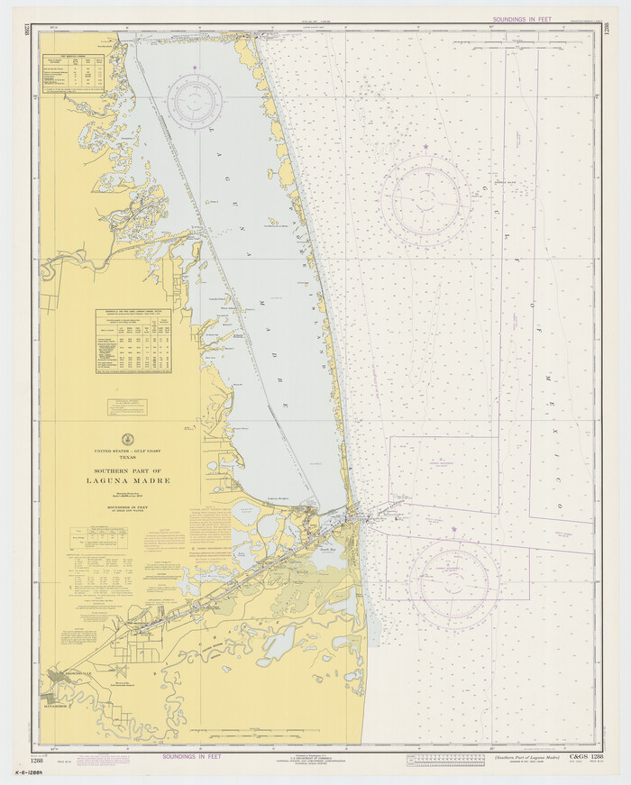
Southern Part of Laguna Madre
Print $20.00
- Digital $50.00
Southern Part of Laguna Madre
1972
Size 44.3 x 35.6 inches
Map/Doc 73542
Montgomery County Sketch File 4

Print $8.00
- Digital $50.00
Montgomery County Sketch File 4
1854
Size 12.0 x 8.1 inches
Map/Doc 31775
Map of Val Verde County

Print $20.00
- Digital $50.00
Map of Val Verde County
1898
Size 42.9 x 37.5 inches
Map/Doc 63098
Reagan County Rolled Sketch 5

Print $20.00
- Digital $50.00
Reagan County Rolled Sketch 5
1928
Size 26.8 x 22.1 inches
Map/Doc 7434