Reagan County Rolled Sketch 5
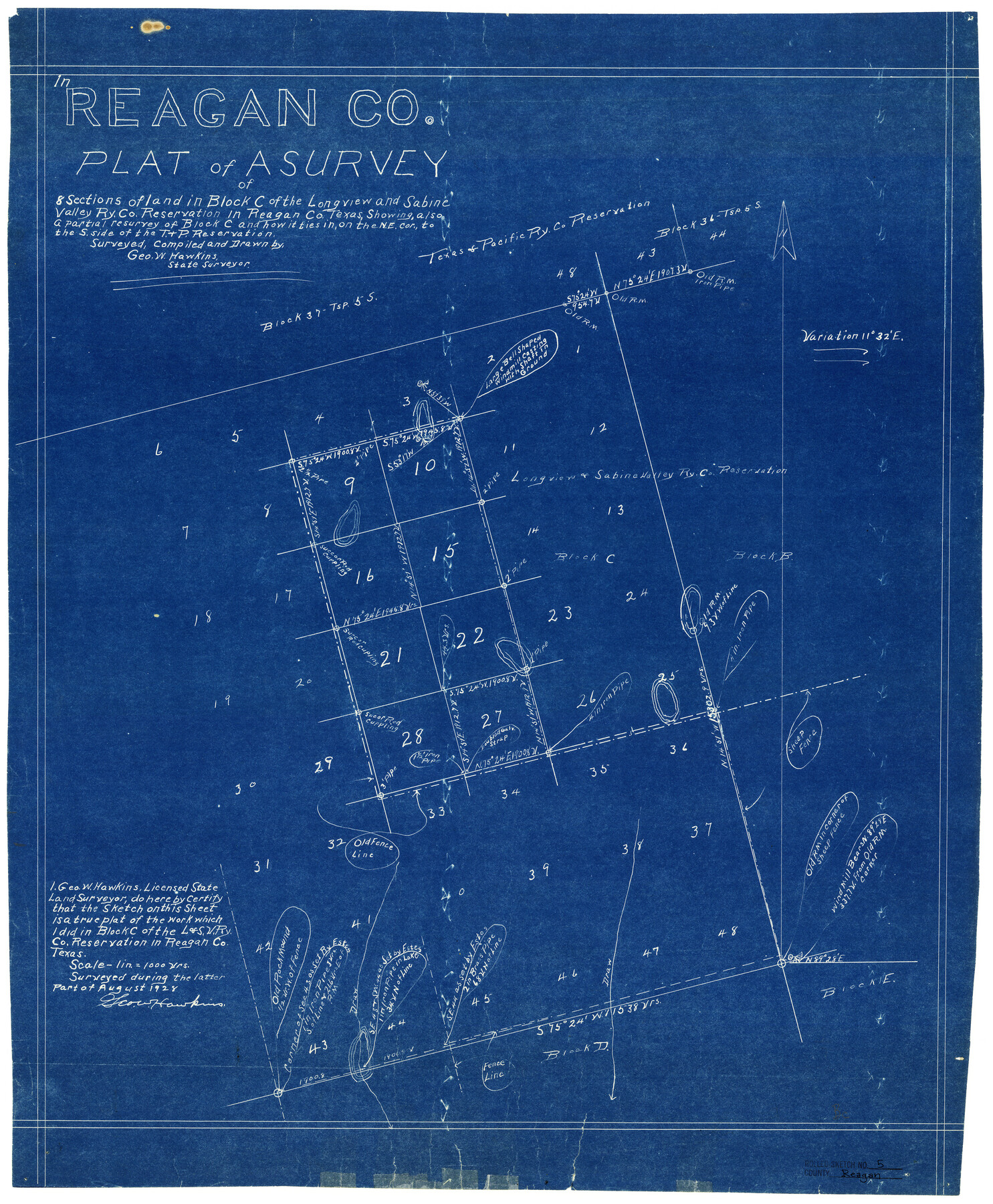
Plat of a survey of 8 sections of land in Block C of the Longview and Sabine Valley Ry. Co. Reservation in Reagan Co., Texas showing also a partial resurvey of Block C and how it ties in, on the NE cor. to the S. side of the T. & P. Reservation
-
Map/Doc
7434
-
Collection
General Map Collection
-
Object Dates
8/1928 (Creation Date)
10/1928 (File Date)
-
People and Organizations
Geo. W. Hawkins (Surveyor/Engineer)
Geo. W. Hawkins (Draftsman)
Geo. W. Hawkins (Compiler)
-
Counties
Reagan
-
Subjects
Surveying Rolled Sketch
-
Height x Width
26.8 x 22.1 inches
68.1 x 56.1 cm
-
Medium
blueprint/diazo
-
Scale
1" = 1000 varas
Part of: General Map Collection
Deaf Smith County Working Sketch 1

Print $20.00
- Digital $50.00
Deaf Smith County Working Sketch 1
1919
Size 27.3 x 14.7 inches
Map/Doc 68641
Flight Mission No. DQO-2K, Frame 85, Galveston County

Print $20.00
- Digital $50.00
Flight Mission No. DQO-2K, Frame 85, Galveston County
1952
Size 18.9 x 22.5 inches
Map/Doc 85012
Loving County Rolled Sketch 1B

Print $40.00
- Digital $50.00
Loving County Rolled Sketch 1B
1952
Size 42.7 x 77.7 inches
Map/Doc 9466
Frio County Sketch File 12

Print $18.00
- Digital $50.00
Frio County Sketch File 12
1938
Size 14.2 x 8.7 inches
Map/Doc 23127
Reeves County Working Sketch 17

Print $20.00
- Digital $50.00
Reeves County Working Sketch 17
1961
Size 30.2 x 30.9 inches
Map/Doc 63460
Pecos County Rolled Sketch 181

Print $20.00
- Digital $50.00
Pecos County Rolled Sketch 181
1980
Size 18.4 x 18.7 inches
Map/Doc 7300
Shelby County Sketch File 11

Print $50.00
- Digital $50.00
Shelby County Sketch File 11
1859
Size 8.8 x 7.0 inches
Map/Doc 36613
Flight Mission No. BQR-9K, Frame 12, Brazoria County

Print $20.00
- Digital $50.00
Flight Mission No. BQR-9K, Frame 12, Brazoria County
1952
Size 18.8 x 22.3 inches
Map/Doc 84041
Sutton County Rolled Sketch 50

Print $40.00
- Digital $50.00
Sutton County Rolled Sketch 50
1950
Size 55.5 x 44.4 inches
Map/Doc 9975

Map of Ellis County

Print $20.00
- Digital $50.00
Map of Ellis County
1857
Size 37.7 x 21.4 inches
Map/Doc 4536
Midland County Rolled Sketch 4

Print $40.00
- Digital $50.00
Midland County Rolled Sketch 4
Size 43.5 x 85.6 inches
Map/Doc 10696
You may also like
Walker County

Print $20.00
- Digital $50.00
Walker County
1944
Size 44.8 x 38.5 inches
Map/Doc 63106
[Aransas Bay]
![72971, [Aransas Bay], General Map Collection](https://historictexasmaps.com/wmedia_w700/maps/72971.tif.jpg)
Print $20.00
- Digital $50.00
[Aransas Bay]
1846
Size 18.2 x 24.7 inches
Map/Doc 72971
Flight Mission No. DCL-6C, Frame 72, Kenedy County

Print $20.00
- Digital $50.00
Flight Mission No. DCL-6C, Frame 72, Kenedy County
1943
Size 18.6 x 22.3 inches
Map/Doc 85914
Flight Mission No. DIX-3P, Frame 135, Aransas County

Print $20.00
- Digital $50.00
Flight Mission No. DIX-3P, Frame 135, Aransas County
1956
Size 17.8 x 18.5 inches
Map/Doc 83765
Crane County Sketch File 20

Print $8.00
- Digital $50.00
Crane County Sketch File 20
1928
Size 11.0 x 8.5 inches
Map/Doc 19586
Flight Mission No. DAG-28K, Frame 32, Matagorda County

Print $20.00
- Digital $50.00
Flight Mission No. DAG-28K, Frame 32, Matagorda County
1953
Size 16.2 x 16.0 inches
Map/Doc 86600
Franklin County Working Sketch 3

Print $20.00
- Digital $50.00
Franklin County Working Sketch 3
1956
Size 19.5 x 16.1 inches
Map/Doc 69241
[Office Sketch Showing George Tenille Grant, Brazoria County, Texas]
![75831, [Office Sketch Showing George Tenille Grant, Brazoria County, Texas], Maddox Collection](https://historictexasmaps.com/wmedia_w700/maps/75831.tif.jpg)
Print $20.00
- Digital $50.00
[Office Sketch Showing George Tenille Grant, Brazoria County, Texas]
Size 38.1 x 28.7 inches
Map/Doc 75831
Presidio County Rolled Sketch 99

Print $20.00
- Digital $50.00
Presidio County Rolled Sketch 99
Size 38.7 x 33.6 inches
Map/Doc 9784
Crockett County Rolled Sketch RC

Print $50.00
- Digital $50.00
Crockett County Rolled Sketch RC
1935
Size 43.2 x 31.1 inches
Map/Doc 8702
Flight Mission No. BRE-5P, Frame 191, Nueces County

Print $20.00
- Digital $50.00
Flight Mission No. BRE-5P, Frame 191, Nueces County
1956
Size 18.7 x 22.5 inches
Map/Doc 86837
Hutchinson County Rolled Sketch 44-6

Print $20.00
- Digital $50.00
Hutchinson County Rolled Sketch 44-6
2002
Size 24.0 x 36.0 inches
Map/Doc 77542