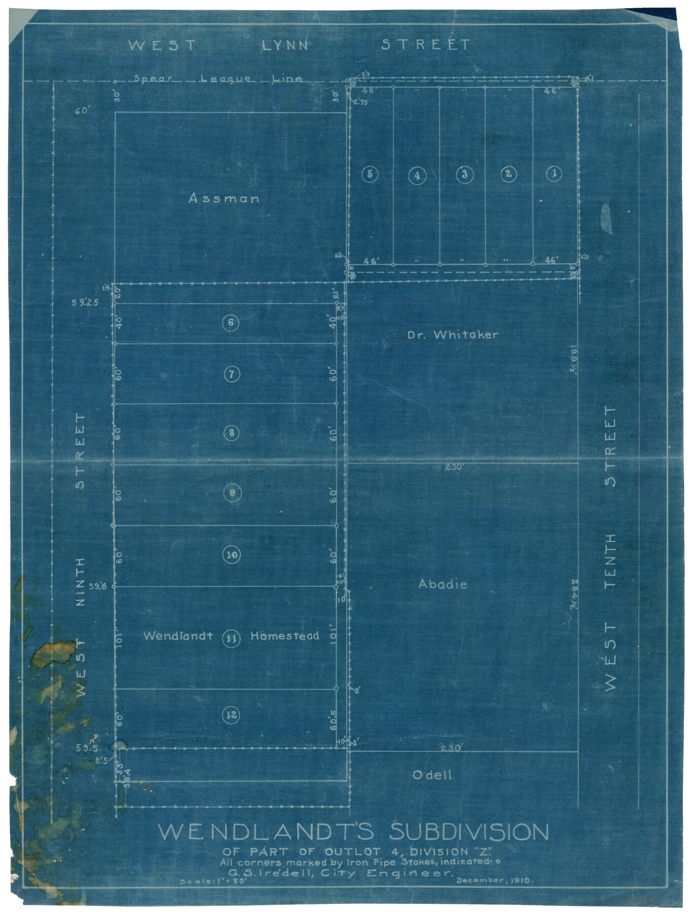
Wendlandt's Subdivision of part of Outlot 4, Division "Z"
-
Map/Doc
5041
-
Collection
Maddox Collection
-
Object Dates
12/1910 (Creation Date)
-
People and Organizations
G.S. Iredell (Surveyor/Engineer)
-
Counties
Travis
-
Subjects
City
-
Height x Width
17.9 x 13.5 inches
45.5 x 34.3 cm
-
Comments
Conservation funded in 2005 by Friends of the Texas General Land Office.
Part of: Maddox Collection
[Office Sketch Showing George Tenille Grant, Brazoria County, Texas]
![75831, [Office Sketch Showing George Tenille Grant, Brazoria County, Texas], Maddox Collection](https://historictexasmaps.com/wmedia_w700/maps/75831.tif.jpg)
Print $20.00
- Digital $50.00
[Office Sketch Showing George Tenille Grant, Brazoria County, Texas]
Size 38.1 x 28.7 inches
Map/Doc 75831
Trinity County, Texas

Print $20.00
- Digital $50.00
Trinity County, Texas
1882
Size 20.3 x 17.4 inches
Map/Doc 485
[Map Showing Surveys in Liberty, Chambers and Harris Counties, Texas]
![75768, [Map Showing Surveys in Liberty, Chambers and Harris Counties, Texas], Maddox Collection](https://historictexasmaps.com/wmedia_w700/maps/75768.tif.jpg)
Print $20.00
- Digital $50.00
[Map Showing Surveys in Liberty, Chambers and Harris Counties, Texas]
1890
Size 16.1 x 21.1 inches
Map/Doc 75768
Free & Williams Subdivision of the north half of Outlots 56 and 57

Print $20.00
- Digital $50.00
Free & Williams Subdivision of the north half of Outlots 56 and 57
Size 10.9 x 29.5 inches
Map/Doc 475
King County, Texas

Print $20.00
- Digital $50.00
King County, Texas
1880
Size 20.0 x 19.4 inches
Map/Doc 737
[Plat Showing Colorado, Upshur & Travis County School Land and Surrounding Area in Baylor & Throckmorton Counties, Texas]
![75790, [Plat Showing Colorado, Upshur & Travis County School Land and Surrounding Area in Baylor & Throckmorton Counties, Texas], Maddox Collection](https://historictexasmaps.com/wmedia_w700/maps/75790.tif.jpg)
Print $20.00
- Digital $50.00
[Plat Showing Colorado, Upshur & Travis County School Land and Surrounding Area in Baylor & Throckmorton Counties, Texas]
1889
Size 15.8 x 20.5 inches
Map/Doc 75790
[Pecos County Sketch]
![444, [Pecos County Sketch], Maddox Collection](https://historictexasmaps.com/wmedia_w700/maps/444.tif.jpg)
Print $20.00
- Digital $50.00
[Pecos County Sketch]
1880
Size 38.5 x 31.3 inches
Map/Doc 444
Castro County, Texas

Print $20.00
- Digital $50.00
Castro County, Texas
1883
Size 20.8 x 18.7 inches
Map/Doc 682
Map showing lands of D. Sullivan known as Santa Rosa Ranch, situated in Cameron and Hidalgo Counties, Texas

Print $20.00
- Digital $50.00
Map showing lands of D. Sullivan known as Santa Rosa Ranch, situated in Cameron and Hidalgo Counties, Texas
1905
Size 26.8 x 27.3 inches
Map/Doc 4451
Map of surveys 189 & 190, T. C. R.R. Co. in Travis County, Texas

Print $20.00
- Digital $50.00
Map of surveys 189 & 190, T. C. R.R. Co. in Travis County, Texas
1915
Size 18.5 x 25.0 inches
Map/Doc 75761
Lipscomb County, Texas

Print $20.00
- Digital $50.00
Lipscomb County, Texas
1880
Size 16.5 x 18.2 inches
Map/Doc 489
Map of Fort Bend County, Texas

Print $20.00
- Digital $50.00
Map of Fort Bend County, Texas
1882
Size 23.0 x 25.7 inches
Map/Doc 434
You may also like
Flight Mission No. DQO-11K, Frame 15, Galveston County

Print $20.00
- Digital $50.00
Flight Mission No. DQO-11K, Frame 15, Galveston County
1952
Size 18.7 x 22.3 inches
Map/Doc 85208
Crockett County Sketch File 4a

Print $20.00
- Digital $50.00
Crockett County Sketch File 4a
Size 28.1 x 8.2 inches
Map/Doc 11215
Sterling County Rolled Sketch 26

Print $20.00
- Digital $50.00
Sterling County Rolled Sketch 26
1955
Size 23.8 x 21.4 inches
Map/Doc 7851
Flight Mission No. DAG-21K, Frame 93, Matagorda County

Print $20.00
- Digital $50.00
Flight Mission No. DAG-21K, Frame 93, Matagorda County
1952
Size 18.6 x 22.2 inches
Map/Doc 86422
Castro County Sketch File 15

Print $4.00
- Digital $50.00
Castro County Sketch File 15
1978
Size 11.2 x 8.7 inches
Map/Doc 17511
Schleicher County Sketch File 26

Print $6.00
- Digital $50.00
Schleicher County Sketch File 26
1938
Size 9.3 x 14.5 inches
Map/Doc 36524
Hansford County Sketch File 6

Print $8.00
- Digital $50.00
Hansford County Sketch File 6
1926
Size 13.6 x 9.0 inches
Map/Doc 24954
Reagan County Rolled Sketch 12

Print $20.00
- Digital $50.00
Reagan County Rolled Sketch 12
1940
Size 25.9 x 27.0 inches
Map/Doc 7440
Flight Mission No. CRK-5P, Frame 162, Refugio County

Print $20.00
- Digital $50.00
Flight Mission No. CRK-5P, Frame 162, Refugio County
1956
Size 18.5 x 22.3 inches
Map/Doc 86943
Hutchinson County Rolled Sketch 44-6

Print $20.00
- Digital $50.00
Hutchinson County Rolled Sketch 44-6
2002
Size 24.0 x 36.0 inches
Map/Doc 77542
Parmer County Working Sketch Graphic Index

Print $20.00
- Digital $50.00
Parmer County Working Sketch Graphic Index
1926
Map/Doc 76662
Township No. 5 South Range No. 15 West, Indian Meridian, Oklahoma

Print $4.00
- Digital $50.00
Township No. 5 South Range No. 15 West, Indian Meridian, Oklahoma
1927
Size 18.2 x 23.9 inches
Map/Doc 75136