Chambers County Sketch File 19
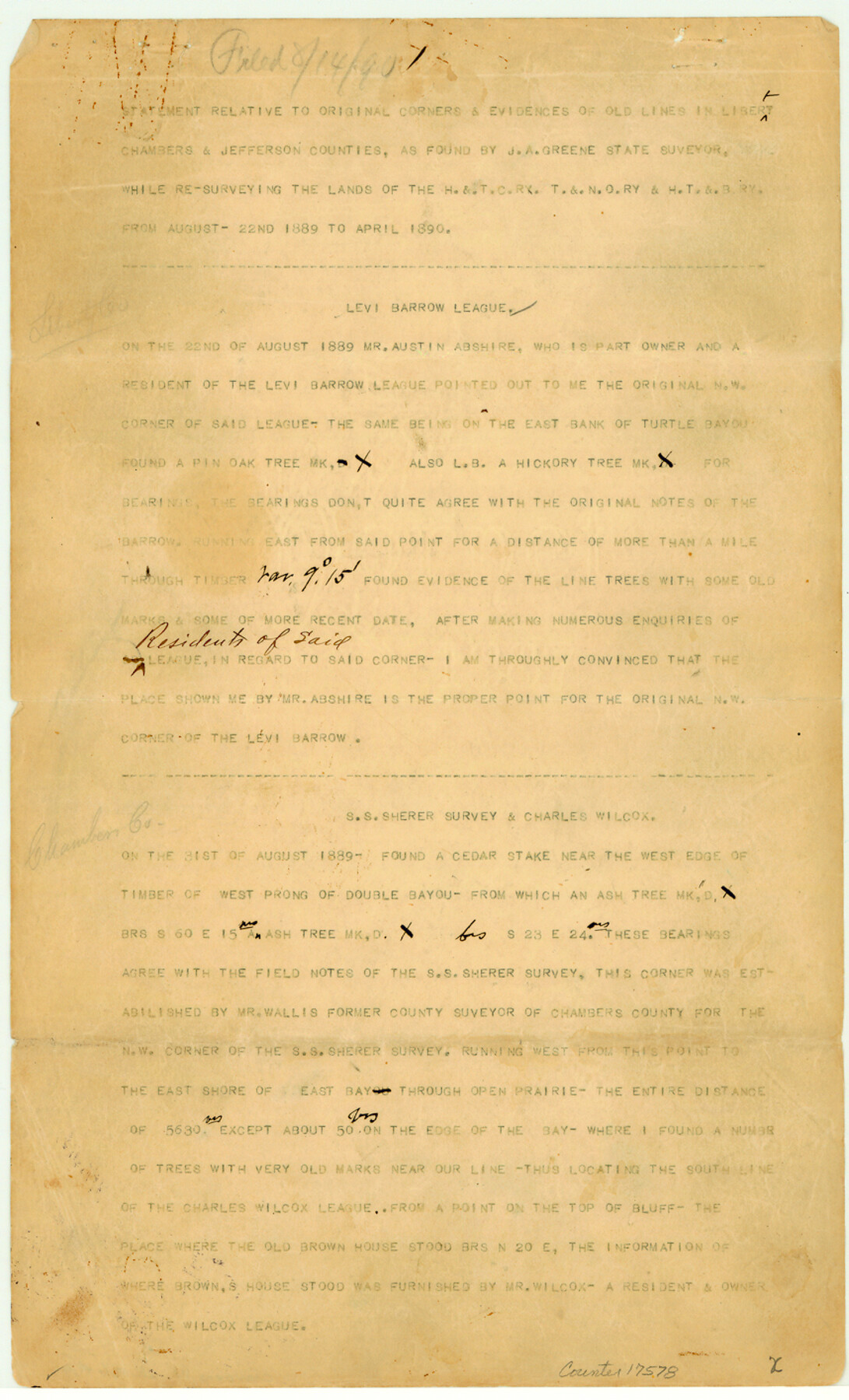
[Statement relative to original corners & evidences of old lines in Liberty, Chambers, & Jefferson Counties, as found by J.A. Greene, State Surveyor, while re-surveying the lands of the H. & T. C. Ry., T. & N. O. Ry., & H. T. & B. Ry.]
-
Map/Doc
17578
-
Collection
General Map Collection
-
Object Dates
1901/8/14 (File Date)
-
People and Organizations
J.A. Greene (Surveyor/Engineer)
-
Counties
Chambers Liberty Jefferson
-
Subjects
Surveying Sketch File
-
Height x Width
14.1 x 8.6 inches
35.8 x 21.8 cm
-
Medium
paper, print
-
Features
Turtle Bayou
Double Bayou
East Bay
Double Bayou Post Office
Taylor's Bayou
LaBelle Post Office
Salt Bayou
Sour Lake
Pine Island Bayou
Oyster Bayou
East Bay Bayou
Part of: General Map Collection
Reeves County Rolled Sketch 33

Print $20.00
- Digital $50.00
Reeves County Rolled Sketch 33
Size 24.2 x 36.5 inches
Map/Doc 7502
Childress County Sketch File 22

Print $32.00
- Digital $50.00
Childress County Sketch File 22
1919
Size 14.3 x 8.7 inches
Map/Doc 18366
Fisher County Working Sketch 11

Print $20.00
- Digital $50.00
Fisher County Working Sketch 11
1952
Size 21.2 x 35.1 inches
Map/Doc 69145
Trinity River, Drop Sheet/Denton Creek

Print $20.00
- Digital $50.00
Trinity River, Drop Sheet/Denton Creek
1940
Size 36.9 x 34.0 inches
Map/Doc 65257
Sterling County Working Sketch 2

Print $20.00
- Digital $50.00
Sterling County Working Sketch 2
1941
Size 19.9 x 26.2 inches
Map/Doc 63984
Hidalgo County Rolled Sketch 12

Print $20.00
- Digital $50.00
Hidalgo County Rolled Sketch 12
1908
Size 21.3 x 27.9 inches
Map/Doc 6211
Baylor County Boundary File 10

Print $38.00
- Digital $50.00
Baylor County Boundary File 10
Size 9.4 x 7.7 inches
Map/Doc 50409
Wheeler County Rolled Sketch 2

Print $20.00
- Digital $50.00
Wheeler County Rolled Sketch 2
1941
Size 44.0 x 22.4 inches
Map/Doc 10137
Flight Mission No. DCL-6C, Frame 134, Kenedy County

Print $20.00
- Digital $50.00
Flight Mission No. DCL-6C, Frame 134, Kenedy County
1943
Size 18.5 x 22.2 inches
Map/Doc 85964
Right of Way and Track Map, Galveston, Harrisburg & San Antonio Ry. operated by the T. & N. O. R.R. Co., Victoria Division, Rosenberg to Beeville

Print $40.00
- Digital $50.00
Right of Way and Track Map, Galveston, Harrisburg & San Antonio Ry. operated by the T. & N. O. R.R. Co., Victoria Division, Rosenberg to Beeville
1918
Size 24.8 x 57.1 inches
Map/Doc 76159
Wise County Working Sketch 18

Print $20.00
- Digital $50.00
Wise County Working Sketch 18
1978
Size 32.8 x 46.5 inches
Map/Doc 72632
Real County Rolled Sketch 13

Print $20.00
- Digital $50.00
Real County Rolled Sketch 13
Size 23.0 x 34.0 inches
Map/Doc 9838
You may also like
San Saba County Sketch File 7a

Print $6.00
- Digital $50.00
San Saba County Sketch File 7a
1883
Size 16.4 x 10.5 inches
Map/Doc 36428

General Chart of the Coast No. XVI - Gulf Coast from Galveston to the Rio Grande

Print $20.00
- Digital $50.00
General Chart of the Coast No. XVI - Gulf Coast from Galveston to the Rio Grande
1883
Size 26.7 x 18.2 inches
Map/Doc 72735
Karnes County Working Sketch 11

Print $40.00
- Digital $50.00
Karnes County Working Sketch 11
1975
Size 38.1 x 53.6 inches
Map/Doc 66659
Map of Jasper County

Print $40.00
- Digital $50.00
Map of Jasper County
1898
Size 48.6 x 39.2 inches
Map/Doc 4990
Roberts County Working Sketch 37

Print $20.00
- Digital $50.00
Roberts County Working Sketch 37
1978
Size 26.6 x 22.5 inches
Map/Doc 63563

Webb County Rolled Sketch 31

Print $20.00
- Digital $50.00
Webb County Rolled Sketch 31
Size 38.8 x 44.5 inches
Map/Doc 10122
Packery Channel

Print $20.00
- Digital $50.00
Packery Channel
1974
Size 16.5 x 20.6 inches
Map/Doc 3003
Cass County Sketch File 21

Print $6.00
- Digital $50.00
Cass County Sketch File 21
1936
Size 14.1 x 8.7 inches
Map/Doc 17424
Taylor County Working Sketch 5

Print $20.00
- Digital $50.00
Taylor County Working Sketch 5
1950
Size 31.1 x 24.7 inches
Map/Doc 69615
Map of Brewster County

Print $20.00
- Digital $50.00
Map of Brewster County
1939
Size 24.5 x 19.5 inches
Map/Doc 3329