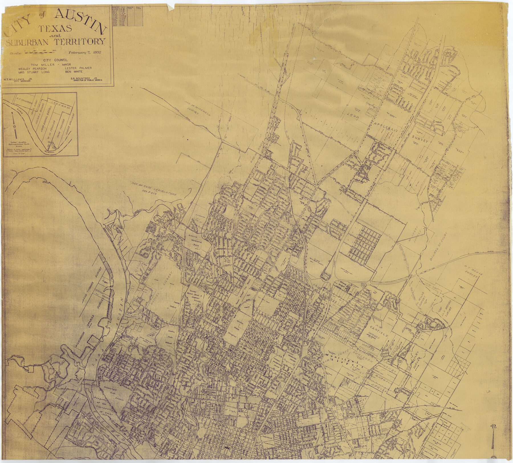
City of Austin, Texas and Suburban Territory
[Northern Part of] City of Austin, Texas and Suburban Territory
RG-2-13
-
Map/Doc
73583
-
Collection
General Map Collection
-
Object Dates
1952/2/7 (Creation Date)
-
Counties
Travis
-
Subjects
City
-
Height x Width
47.8 x 53.0 inches
121.4 x 134.6 cm
-
Comments
Shows subdivision names, street block numbers, owners, and acreage of larger out-lying tracts.
Map was scanned in two segments. See map 73582 for segment 2.
Part of: General Map Collection
Orange County Sketch File 26

Print $20.00
- Digital $50.00
Orange County Sketch File 26
Size 38.5 x 29.3 inches
Map/Doc 10564
Jefferson County Rolled Sketch 61D

Print $20.00
- Digital $50.00
Jefferson County Rolled Sketch 61D
Size 27.2 x 40.5 inches
Map/Doc 6413
Clay County Rolled Sketch 4A

Print $20.00
- Digital $50.00
Clay County Rolled Sketch 4A
1949
Size 22.0 x 24.0 inches
Map/Doc 5498
Kinney County Working Sketch 42

Print $20.00
- Digital $50.00
Kinney County Working Sketch 42
1973
Size 20.4 x 33.7 inches
Map/Doc 70224
Dawson County Working Sketch 5

Print $20.00
- Digital $50.00
Dawson County Working Sketch 5
1926
Size 22.3 x 26.1 inches
Map/Doc 68548
Menard County

Print $20.00
- Digital $50.00
Menard County
1942
Size 43.6 x 47.7 inches
Map/Doc 77371
Cottle County Sketch File H

Print $12.00
- Digital $50.00
Cottle County Sketch File H
1976
Size 11.2 x 8.7 inches
Map/Doc 19451
Upton County Sketch File 32

Print $20.00
- Digital $50.00
Upton County Sketch File 32
1938
Size 14.9 x 24.0 inches
Map/Doc 12523
Coke County Sketch File 23

Print $20.00
- Digital $50.00
Coke County Sketch File 23
Size 43.9 x 18.5 inches
Map/Doc 10338
Menard County Sketch File 20

Print $8.00
- Digital $50.00
Menard County Sketch File 20
1911
Size 14.2 x 8.7 inches
Map/Doc 31548
Shackelford County Working Sketch Graphic Index

Print $20.00
- Digital $50.00
Shackelford County Working Sketch Graphic Index
1972
Size 42.2 x 36.1 inches
Map/Doc 76696
Zavala County Working Sketch 4

Print $20.00
- Digital $50.00
Zavala County Working Sketch 4
1936
Size 21.1 x 23.4 inches
Map/Doc 62079
You may also like
Kinney County Working Sketch 56

Print $40.00
- Digital $50.00
Kinney County Working Sketch 56
1987
Size 40.5 x 62.8 inches
Map/Doc 70238
Florida called by ye French Louisiana & c.

Print $20.00
- Digital $50.00
Florida called by ye French Louisiana & c.
1728
Size 9.6 x 14.3 inches
Map/Doc 94110
Flight Mission No. CGI-1N, Frame 181, Cameron County

Print $20.00
- Digital $50.00
Flight Mission No. CGI-1N, Frame 181, Cameron County
1955
Size 18.7 x 22.2 inches
Map/Doc 84516
Cameron County Sketch File 2

Print $98.00
- Digital $50.00
Cameron County Sketch File 2
1904
Size 14.3 x 8.7 inches
Map/Doc 16975
United States - Gulf Coast - Padre I. and Laguna Madre Lat. 27° 12' to Lat. 26° 33' Texas

Print $20.00
- Digital $50.00
United States - Gulf Coast - Padre I. and Laguna Madre Lat. 27° 12' to Lat. 26° 33' Texas
1913
Size 27.0 x 18.3 inches
Map/Doc 72819

Terrell County Rolled Sketch 57

Print $20.00
- Digital $50.00
Terrell County Rolled Sketch 57
1986
Size 33.0 x 25.2 inches
Map/Doc 7974
Maps of Gulf Intracoastal Waterway, Texas - Sabine River to the Rio Grande and connecting waterways including ship channels

Print $20.00
- Digital $50.00
Maps of Gulf Intracoastal Waterway, Texas - Sabine River to the Rio Grande and connecting waterways including ship channels
1966
Size 14.6 x 22.3 inches
Map/Doc 61962
Potter County Boundary File 2b

Print $10.00
- Digital $50.00
Potter County Boundary File 2b
Size 13.4 x 8.4 inches
Map/Doc 57969
Map of Burleson County, Texas

Print $20.00
- Digital $50.00
Map of Burleson County, Texas
1879
Size 16.1 x 21.1 inches
Map/Doc 667
General Highway Map, Crosby County, Texas

Print $20.00
- Digital $50.00
General Highway Map, Crosby County, Texas
1950
Size 25.7 x 18.8 inches
Map/Doc 92596
Jim Hogg County Rolled Sketch 4

Print $20.00
- Digital $50.00
Jim Hogg County Rolled Sketch 4
Size 17.0 x 30.5 inches
Map/Doc 6440