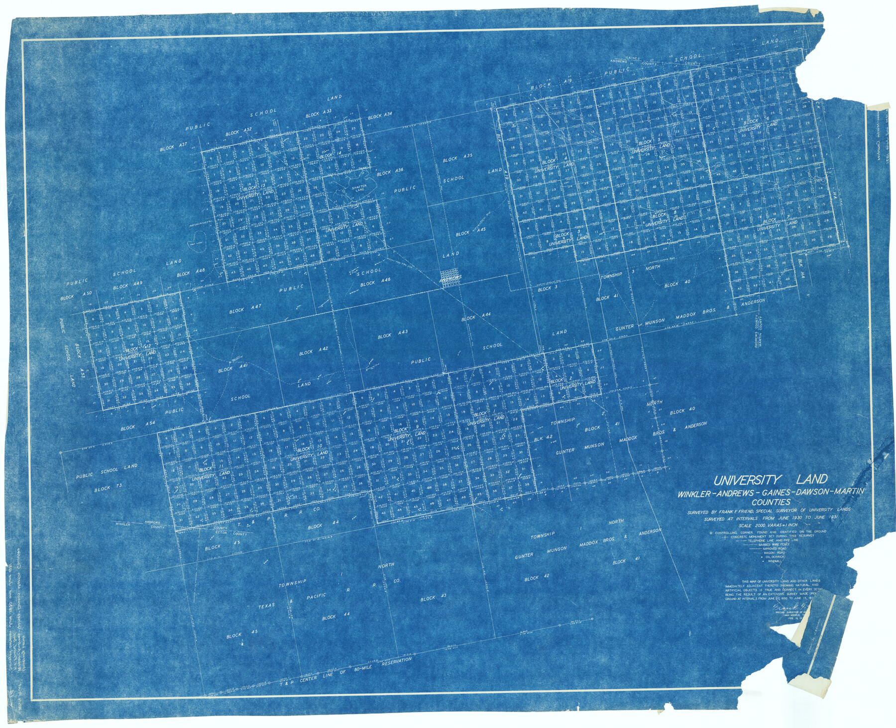
University Land, Winkler-Andrews-Gaines-Dawson-Martin Counties
K-8-101c; K-8-214
-
Map/Doc
2419
-
Collection
General Map Collection
-
Object Dates
1931 (Creation Date)
-
People and Organizations
Frank F. Friend (Surveyor/Engineer)
-
Counties
Winkler Andrews Gaines Dawson Martin
-
Subjects
University Land
-
Height x Width
42.3 x 52.1 inches
107.4 x 132.3 cm
Part of: General Map Collection
Bowie County Working Sketch 25

Print $20.00
- Digital $50.00
Bowie County Working Sketch 25
1977
Size 20.5 x 33.9 inches
Map/Doc 67429
Dimmit County Working Sketch 49

Print $40.00
- Digital $50.00
Dimmit County Working Sketch 49
1980
Size 78.8 x 44.7 inches
Map/Doc 68710
Hill County Working Sketch 1

Print $20.00
- Digital $50.00
Hill County Working Sketch 1
1939
Size 11.0 x 17.8 inches
Map/Doc 66187
Calhoun County Rolled Sketch 11
Print $3.00
- Digital $50.00
Calhoun County Rolled Sketch 11
1942
Size 10.9 x 16.2 inches
Map/Doc 5462
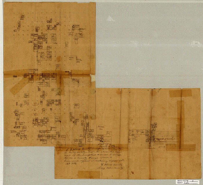
Collin County Sketch File 3
Print $20.00
- Digital $50.00
Collin County Sketch File 3
1852
Size 19.5 x 21.4 inches
Map/Doc 11126
Travis County Boundary File 28

Print $8.00
- Digital $50.00
Travis County Boundary File 28
Size 14.7 x 9.0 inches
Map/Doc 59464
Real County Sketch File 6

Print $20.00
- Digital $50.00
Real County Sketch File 6
1931
Size 17.3 x 19.6 inches
Map/Doc 12229
Edwards County Sketch File 41

Print $20.00
- Digital $50.00
Edwards County Sketch File 41
Size 33.7 x 22.7 inches
Map/Doc 11439
Map of Hamilton County

Print $20.00
- Digital $50.00
Map of Hamilton County
1872
Size 14.6 x 21.7 inches
Map/Doc 3620
Lavaca County Rolled Sketch 2

Print $20.00
- Digital $50.00
Lavaca County Rolled Sketch 2
1951
Size 37.0 x 26.7 inches
Map/Doc 6592
Frio County Sketch File 23

Print $6.00
- Digital $50.00
Frio County Sketch File 23
2013
Size 11.0 x 8.5 inches
Map/Doc 93418
Borden County Sketch File 9

Print $6.00
- Digital $50.00
Borden County Sketch File 9
Size 10.2 x 13.4 inches
Map/Doc 14728
You may also like
Map showing those portions of Texas traversed by the Rock Island System and connecting lines

Print $20.00
- Digital $50.00
Map showing those portions of Texas traversed by the Rock Island System and connecting lines
1903
Size 16.4 x 24.0 inches
Map/Doc 96587
Lampasas County Sketch File 1

Print $4.00
- Digital $50.00
Lampasas County Sketch File 1
Size 12.6 x 8.1 inches
Map/Doc 29388
Polk County Rolled Sketch TMS

Print $40.00
- Digital $50.00
Polk County Rolled Sketch TMS
1937
Size 35.7 x 56.5 inches
Map/Doc 9756
Goliad County Working Sketch 14

Print $20.00
- Digital $50.00
Goliad County Working Sketch 14
1946
Size 29.5 x 42.8 inches
Map/Doc 63204
Duval County Rolled Sketch 22

Print $20.00
- Digital $50.00
Duval County Rolled Sketch 22
1942
Size 19.5 x 30.0 inches
Map/Doc 5741
El Paso County Working Sketch 51

Print $20.00
- Digital $50.00
El Paso County Working Sketch 51
1992
Size 19.7 x 13.0 inches
Map/Doc 69073
Starr County Rolled Sketch 16

Print $20.00
- Digital $50.00
Starr County Rolled Sketch 16
1913
Size 18.6 x 21.9 inches
Map/Doc 7801
Nolan County Sketch File 16

Print $20.00
- Digital $50.00
Nolan County Sketch File 16
1938
Size 18.9 x 23.4 inches
Map/Doc 42166
[John H. Robinson, John H. Gibson, and vicinity]
![91043, [John H. Robinson, John H. Gibson, and vicinity], Twichell Survey Records](https://historictexasmaps.com/wmedia_w700/maps/91043-1.tif.jpg)
Print $20.00
- Digital $50.00
[John H. Robinson, John H. Gibson, and vicinity]
Size 19.9 x 29.5 inches
Map/Doc 91043
Upton County Rolled Sketch 51

Print $20.00
- Digital $50.00
Upton County Rolled Sketch 51
1961
Size 34.0 x 29.8 inches
Map/Doc 8086
[R. M. Thompson Blk. T]
![90409, [R. M. Thompson Blk. T], Twichell Survey Records](https://historictexasmaps.com/wmedia_w700/maps/90409-1.tif.jpg)
Print $20.00
- Digital $50.00
[R. M. Thompson Blk. T]
Size 16.6 x 21.7 inches
Map/Doc 90409
Denison, Texas, Grayson County 1886

Print $20.00
Denison, Texas, Grayson County 1886
1886
Size 21.1 x 30.5 inches
Map/Doc 93466