Brewster County Rolled Sketch 114
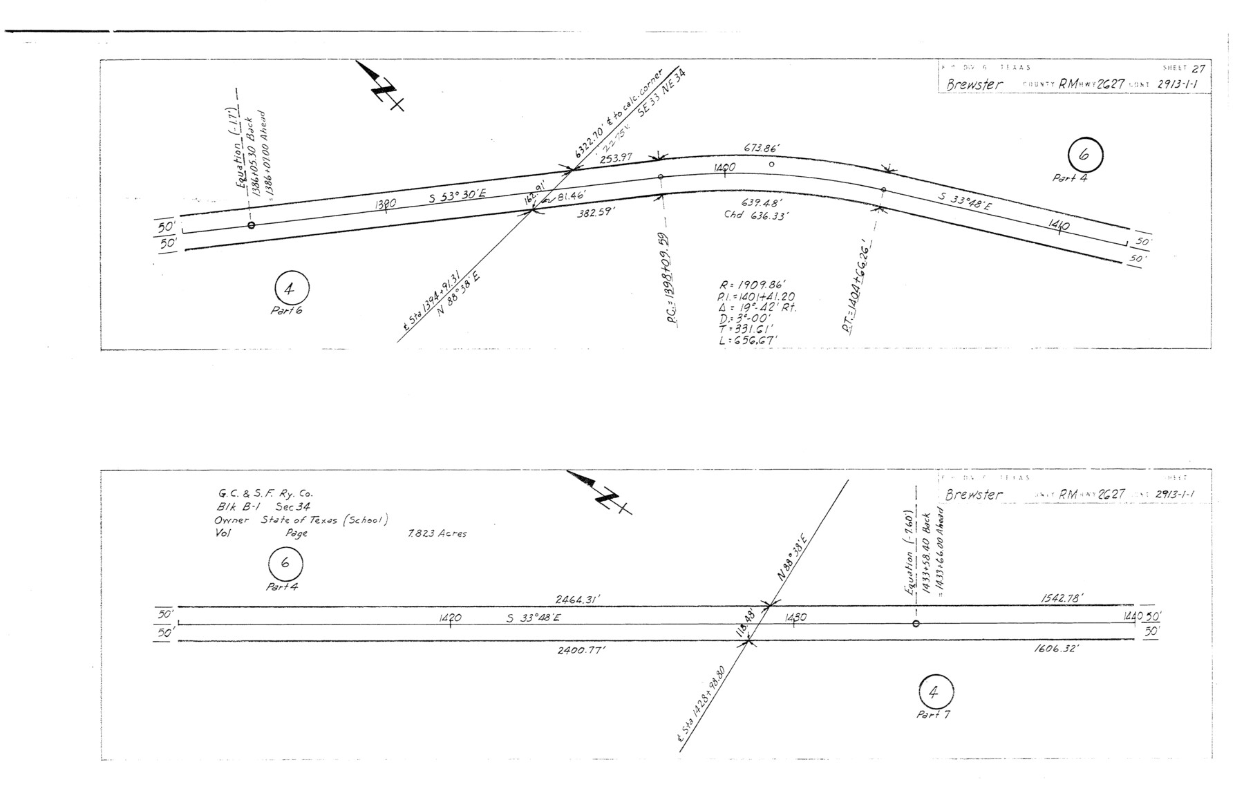
Plans of proposed State Highway Right of Way, RM Highway 2627, Brewster County, Control 2913-1-1 from: US 383, 38 mi. S of Marathon, SE to: Heath Crossing on Rio Grande (Sheet 27)
-
Map/Doc
5290
-
Collection
General Map Collection
-
Object Dates
1965/3/29 (File Date)
1964/12/3 (Creation Date)
-
People and Organizations
State Highway Department (Publisher)
-
Counties
Brewster
-
Subjects
Surveying Rolled Sketch
-
Height x Width
11.9 x 18.3 inches
30.2 x 46.5 cm
-
Medium
blueprint/diazo
-
Comments
This is one sheet of a set of 29 maps. For the complete set, see map numbers 5264-5292.
Related maps
Brewster County Rolled Sketch 114

Print $20.00
- Digital $50.00
Brewster County Rolled Sketch 114
1964
Size 11.8 x 18.5 inches
Map/Doc 5264
Brewster County Rolled Sketch 114

Print $20.00
- Digital $50.00
Brewster County Rolled Sketch 114
1964
Size 11.7 x 18.4 inches
Map/Doc 5265
Brewster County Rolled Sketch 114

Print $20.00
- Digital $50.00
Brewster County Rolled Sketch 114
1964
Size 11.7 x 18.6 inches
Map/Doc 5266
Brewster County Rolled Sketch 114

Print $20.00
- Digital $50.00
Brewster County Rolled Sketch 114
1964
Size 11.7 x 18.4 inches
Map/Doc 5267
Brewster County Rolled Sketch 114

Print $20.00
- Digital $50.00
Brewster County Rolled Sketch 114
1964
Size 23.8 x 18.9 inches
Map/Doc 5268
Brewster County Rolled Sketch 114

Print $20.00
- Digital $50.00
Brewster County Rolled Sketch 114
1964
Size 11.0 x 18.3 inches
Map/Doc 5269
Brewster County Rolled Sketch 114

Print $20.00
- Digital $50.00
Brewster County Rolled Sketch 114
1964
Size 11.1 x 18.4 inches
Map/Doc 5270
Brewster County Rolled Sketch 114

Print $20.00
- Digital $50.00
Brewster County Rolled Sketch 114
1964
Size 11.5 x 18.5 inches
Map/Doc 5271
Brewster County Rolled Sketch 114

Print $20.00
- Digital $50.00
Brewster County Rolled Sketch 114
1964
Size 11.6 x 18.3 inches
Map/Doc 5272
Brewster County Rolled Sketch 114

Print $20.00
- Digital $50.00
Brewster County Rolled Sketch 114
1964
Size 11.6 x 17.3 inches
Map/Doc 5273
Brewster County Rolled Sketch 114

Print $20.00
- Digital $50.00
Brewster County Rolled Sketch 114
1964
Size 11.5 x 17.6 inches
Map/Doc 5274
Brewster County Rolled Sketch 114

Print $20.00
- Digital $50.00
Brewster County Rolled Sketch 114
1964
Size 11.6 x 18.5 inches
Map/Doc 5275
Brewster County Rolled Sketch 114

Print $20.00
- Digital $50.00
Brewster County Rolled Sketch 114
1964
Size 11.7 x 18.3 inches
Map/Doc 5276
Brewster County Rolled Sketch 114

Print $20.00
- Digital $50.00
Brewster County Rolled Sketch 114
1964
Size 11.4 x 18.4 inches
Map/Doc 5277
Brewster County Rolled Sketch 114

Print $20.00
- Digital $50.00
Brewster County Rolled Sketch 114
1964
Size 12.0 x 18.4 inches
Map/Doc 5278
Brewster County Rolled Sketch 114

Print $20.00
- Digital $50.00
Brewster County Rolled Sketch 114
1964
Size 11.9 x 18.4 inches
Map/Doc 5279
Brewster County Rolled Sketch 114

Print $20.00
- Digital $50.00
Brewster County Rolled Sketch 114
1964
Size 11.9 x 18.3 inches
Map/Doc 5280
Brewster County Rolled Sketch 114

Print $20.00
- Digital $50.00
Brewster County Rolled Sketch 114
1964
Size 11.7 x 17.7 inches
Map/Doc 5281
Brewster County Rolled Sketch 114

Print $20.00
- Digital $50.00
Brewster County Rolled Sketch 114
1964
Size 11.4 x 18.2 inches
Map/Doc 5282
Brewster County Rolled Sketch 114

Print $20.00
- Digital $50.00
Brewster County Rolled Sketch 114
1964
Size 12.2 x 17.5 inches
Map/Doc 5283
Part of: General Map Collection
Travis County Rolled Sketch 17

Print $20.00
- Digital $50.00
Travis County Rolled Sketch 17
1940
Size 18.8 x 25.4 inches
Map/Doc 8019
Wichita County Working Sketch 29

Print $20.00
- Digital $50.00
Wichita County Working Sketch 29
2014
Size 16.7 x 20.0 inches
Map/Doc 93688
Brown County Sketch File 11a

Print $6.00
- Digital $50.00
Brown County Sketch File 11a
1872
Size 6.6 x 3.6 inches
Map/Doc 16599
Brewster County Rolled Sketch 118

Print $20.00
- Digital $50.00
Brewster County Rolled Sketch 118
1971
Size 25.3 x 37.2 inches
Map/Doc 5295
Starr County Sketch File 23

Print $16.00
- Digital $50.00
Starr County Sketch File 23
1922
Size 10.7 x 8.8 inches
Map/Doc 36919
Harris County Rolled Sketch 31

Print $40.00
- Digital $50.00
Harris County Rolled Sketch 31
1893
Size 63.5 x 40.0 inches
Map/Doc 9111
Flight Mission No. CRK-3P, Frame 65, Refugio County

Print $20.00
- Digital $50.00
Flight Mission No. CRK-3P, Frame 65, Refugio County
1956
Size 18.5 x 22.4 inches
Map/Doc 86907
Bosque County Sketch File 5

Print $6.00
- Digital $50.00
Bosque County Sketch File 5
1847
Size 15.7 x 10.4 inches
Map/Doc 14746
Red River County Working Sketch 81-3

Print $20.00
- Digital $50.00
Red River County Working Sketch 81-3
1987
Size 17.5 x 21.5 inches
Map/Doc 72066

Gregg County Rolled Sketch 8A

Print $40.00
- Digital $50.00
Gregg County Rolled Sketch 8A
Size 25.5 x 50.3 inches
Map/Doc 9028
Stephens County Working Sketch 30

Print $20.00
- Digital $50.00
Stephens County Working Sketch 30
1977
Size 26.4 x 15.7 inches
Map/Doc 63973
You may also like
Map of subdivision of submerged land in the Gulf of Mexico fronting on Matagorda Island and Peninsula

Print $40.00
- Digital $50.00
Map of subdivision of submerged land in the Gulf of Mexico fronting on Matagorda Island and Peninsula
1940
Size 21.5 x 70.0 inches
Map/Doc 2931
Runnels County Working Sketch 15

Print $20.00
- Digital $50.00
Runnels County Working Sketch 15
1950
Size 22.8 x 18.5 inches
Map/Doc 63611
Cherokee County Working Sketch 18

Print $40.00
- Digital $50.00
Cherokee County Working Sketch 18
1958
Size 74.6 x 43.6 inches
Map/Doc 67973
Kent County Working Sketch 5

Print $40.00
- Digital $50.00
Kent County Working Sketch 5
1950
Size 36.7 x 50.1 inches
Map/Doc 70012
Cherokee County Sketch File 2

Print $6.00
- Digital $50.00
Cherokee County Sketch File 2
1857
Size 8.2 x 7.9 inches
Map/Doc 18112
Donley County Boundary File 8

Print $4.00
- Digital $50.00
Donley County Boundary File 8
Size 11.2 x 8.7 inches
Map/Doc 52655
Pecos County Working Sketch 58

Print $20.00
- Digital $50.00
Pecos County Working Sketch 58
1949
Size 20.5 x 22.0 inches
Map/Doc 71530
Harbor of Brazos Santiago, Texas

Print $20.00
- Digital $50.00
Harbor of Brazos Santiago, Texas
1887
Size 27.0 x 18.3 inches
Map/Doc 72993
Sketch of Motley Co.

Print $20.00
- Digital $50.00
Sketch of Motley Co.
1883
Size 19.7 x 20.2 inches
Map/Doc 75560
Brewster County Rolled Sketch 49

Print $20.00
- Digital $50.00
Brewster County Rolled Sketch 49
1930
Size 35.1 x 47.4 inches
Map/Doc 8478
Flight Mission No. DIX-10P, Frame 165, Aransas County

Print $20.00
- Digital $50.00
Flight Mission No. DIX-10P, Frame 165, Aransas County
1956
Size 18.6 x 22.3 inches
Map/Doc 83955
