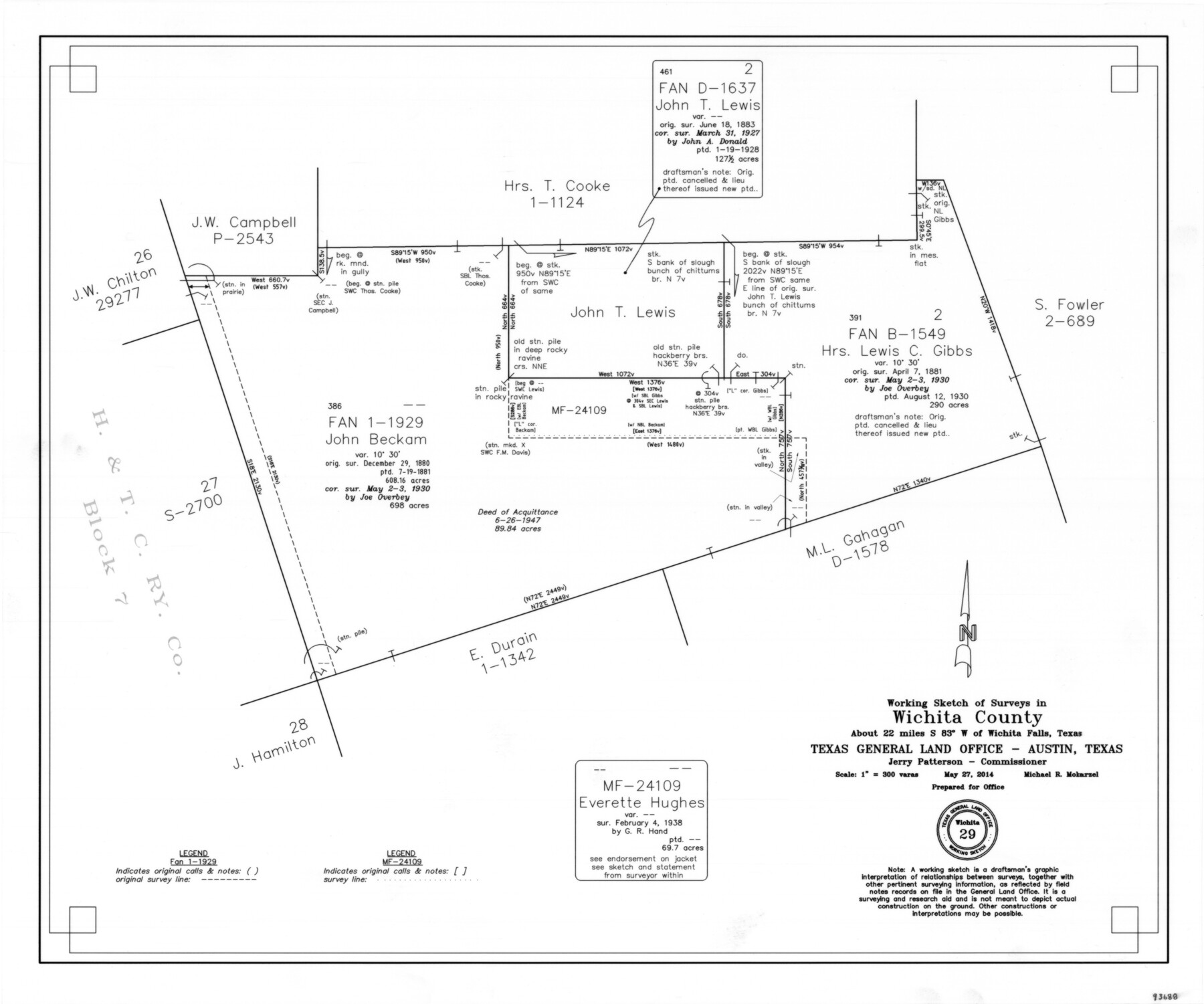
Wichita County Working Sketch 29
-
Map/Doc
93688
-
Collection
General Map Collection
-
Object Dates
5/27/2014 (Creation Date)
-
People and Organizations
Michael R. Mokarzel (Draftsman)
-
Counties
Wichita
-
Subjects
Surveying Working Sketch
-
Height x Width
16.7 x 20.0 inches
42.4 x 50.8 cm
-
Scale
1" = 300 varas
Part of: General Map Collection
Notes for map of Montgomery County

Print $20.00
- Digital $50.00
Notes for map of Montgomery County
1844
Size 17.6 x 21.9 inches
Map/Doc 78370
Carta Historica y Arqueologica

Print $20.00
- Digital $50.00
Carta Historica y Arqueologica
Size 26.0 x 34.4 inches
Map/Doc 96806
Mason County Working Sketch 4

Print $20.00
- Digital $50.00
Mason County Working Sketch 4
1932
Size 16.6 x 22.2 inches
Map/Doc 70840
Bell County Sketch File 29a

Print $4.00
- Digital $50.00
Bell County Sketch File 29a
1875
Size 12.4 x 8.6 inches
Map/Doc 14441
Texas Intracoastal Waterway - Stover Point to Port Brownsville including Brazos Santiago

Print $20.00
- Digital $50.00
Texas Intracoastal Waterway - Stover Point to Port Brownsville including Brazos Santiago
1965
Size 27.5 x 38.9 inches
Map/Doc 73521
Texas and Mexico showing Houston and Texas Central System of Railways

Print $20.00
- Digital $50.00
Texas and Mexico showing Houston and Texas Central System of Railways
1885
Size 29.0 x 21.6 inches
Map/Doc 94274
Wichita County Working Sketch 24

Print $20.00
- Digital $50.00
Wichita County Working Sketch 24
1971
Size 21.2 x 16.2 inches
Map/Doc 72534
Terrell County Rolled Sketch 56

Print $20.00
- Digital $50.00
Terrell County Rolled Sketch 56
1986
Size 36.6 x 42.0 inches
Map/Doc 9992
Potter County Sketch File 12

Print $4.00
- Digital $50.00
Potter County Sketch File 12
1890
Size 6.0 x 8.7 inches
Map/Doc 34399
Current Miscellaneous File 47

Print $12.00
- Digital $50.00
Current Miscellaneous File 47
1920
Size 16.3 x 9.2 inches
Map/Doc 73992
Willacy County Working Sketch Graphic Index

Print $20.00
- Digital $50.00
Willacy County Working Sketch Graphic Index
1921
Size 32.8 x 32.7 inches
Map/Doc 76741
Greer County Sketch File 6

Print $4.00
- Digital $50.00
Greer County Sketch File 6
Size 14.2 x 8.8 inches
Map/Doc 24524
You may also like
Presidio County Sketch File 64

Print $20.00
- Digital $50.00
Presidio County Sketch File 64
1938
Size 16.5 x 26.5 inches
Map/Doc 11719
Bell County Sketch File 19a

Print $4.00
- Digital $50.00
Bell County Sketch File 19a
Size 8.1 x 8.7 inches
Map/Doc 14404
[H. & T. C. RR. Company, Block 47, Map C]
![91258, [H. & T. C. RR. Company, Block 47, Map C], Twichell Survey Records](https://historictexasmaps.com/wmedia_w700/maps/91258-1.tif.jpg)
Print $20.00
- Digital $50.00
[H. & T. C. RR. Company, Block 47, Map C]
Size 34.1 x 20.7 inches
Map/Doc 91258
Val Verde County Working Sketch 14

Print $20.00
- Digital $50.00
Val Verde County Working Sketch 14
1926
Size 17.2 x 18.9 inches
Map/Doc 72149
Webb County Working Sketch 57

Print $20.00
- Digital $50.00
Webb County Working Sketch 57
1958
Size 24.9 x 38.0 inches
Map/Doc 72423

Titus County Working Sketch 8

Print $20.00
- Digital $50.00
Titus County Working Sketch 8
1974
Size 17.6 x 29.3 inches
Map/Doc 69369
Flight Mission No. DAG-17K, Frame 135, Matagorda County

Print $20.00
- Digital $50.00
Flight Mission No. DAG-17K, Frame 135, Matagorda County
1952
Size 17.4 x 16.1 inches
Map/Doc 86352
Brewster County Rolled Sketch 60

Print $40.00
- Digital $50.00
Brewster County Rolled Sketch 60
Size 36.6 x 50.3 inches
Map/Doc 10692
El Paso County Rolled Sketch 52

Print $20.00
- Digital $50.00
El Paso County Rolled Sketch 52
1929
Size 18.5 x 24.4 inches
Map/Doc 5838
Runnels County Working Sketch 16

Print $20.00
- Digital $50.00
Runnels County Working Sketch 16
1950
Size 30.1 x 35.5 inches
Map/Doc 63612
Brazoria County Sketch File 10

Print $40.00
- Digital $50.00
Brazoria County Sketch File 10
Size 16.4 x 12.7 inches
Map/Doc 14938