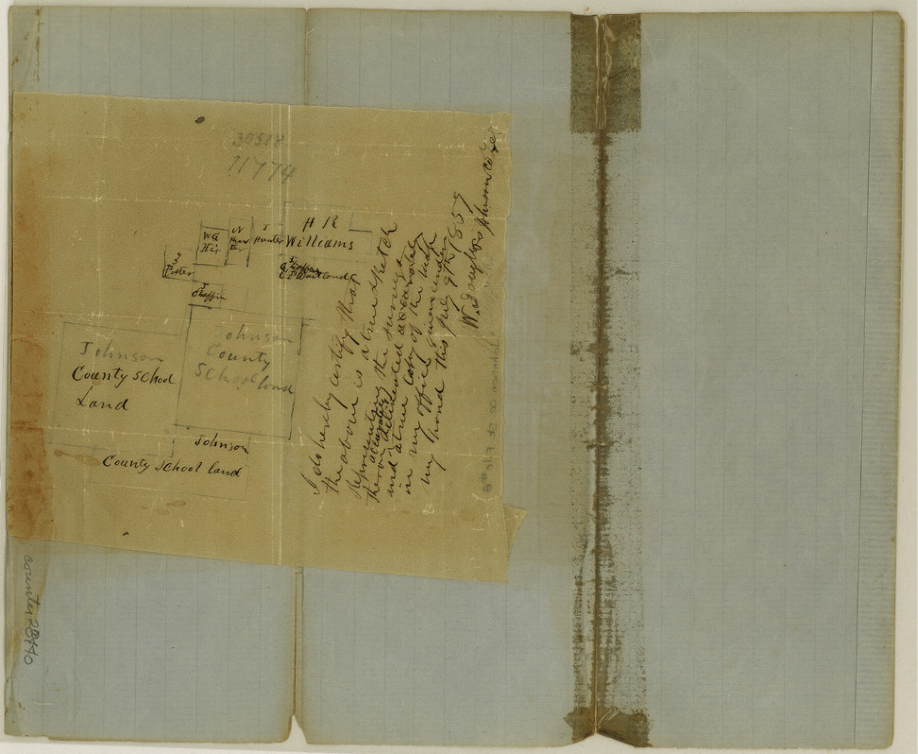
Johnson County Sketch File 8
[Three sketches in northwest part of county]
-
Map/Doc
28440
-
Collection
General Map Collection
-
Object Dates
10/3/1859 (Creation Date)
9/9/1859 (File Date)
-
People and Organizations
W. Douglass (Surveyor/Engineer)
-
Counties
Johnson
-
Subjects
Surveying Sketch File
-
Height x Width
8.0 x 9.7 inches
20.3 x 24.6 cm
-
Medium
paper, manuscript
Part of: General Map Collection
Kent County Rolled Sketch 5

Print $20.00
- Digital $50.00
Kent County Rolled Sketch 5
1951
Size 43.7 x 36.9 inches
Map/Doc 78522
Webb County Sketch File B2

Print $4.00
- Digital $50.00
Webb County Sketch File B2
1909
Size 13.9 x 8.1 inches
Map/Doc 39656
Flight Mission No. CUG-1P, Frame 168, Kleberg County

Print $20.00
- Digital $50.00
Flight Mission No. CUG-1P, Frame 168, Kleberg County
1956
Size 18.6 x 22.2 inches
Map/Doc 86175
[FT. W. & R. G. Ry. Right of Way Map, Winchell to Brady, McCulloch County, Texas]
![61415, [FT. W. & R. G. Ry. Right of Way Map, Winchell to Brady, McCulloch County, Texas], General Map Collection](https://historictexasmaps.com/wmedia_w700/maps/61415.tif.jpg)
Print $40.00
- Digital $50.00
[FT. W. & R. G. Ry. Right of Way Map, Winchell to Brady, McCulloch County, Texas]
1918
Size 38.2 x 122.0 inches
Map/Doc 61415
Wichita County Sketch File 34

Print $6.00
- Digital $50.00
Wichita County Sketch File 34
1949
Size 14.4 x 8.8 inches
Map/Doc 40154
Map of Hill County

Print $20.00
- Digital $50.00
Map of Hill County
1884
Size 47.2 x 36.8 inches
Map/Doc 16851
El Paso County Working Sketch 11

Print $40.00
- Digital $50.00
El Paso County Working Sketch 11
1955
Size 49.2 x 43.4 inches
Map/Doc 69033
Crockett County Rolled Sketch 3

Print $20.00
- Digital $50.00
Crockett County Rolled Sketch 3
1886
Size 18.1 x 22.9 inches
Map/Doc 5579
Flight Mission No. DQN-1K, Frame 105, Calhoun County

Print $20.00
- Digital $50.00
Flight Mission No. DQN-1K, Frame 105, Calhoun County
1953
Size 18.4 x 22.2 inches
Map/Doc 84172
Bailey County Sketch File 3

Print $22.00
- Digital $50.00
Bailey County Sketch File 3
1901
Size 8.9 x 6.8 inches
Map/Doc 13937
Travis County Working Sketch 54

Print $20.00
- Digital $50.00
Travis County Working Sketch 54
1976
Size 30.1 x 32.0 inches
Map/Doc 69438
Hood County Working Sketch 14

Print $20.00
- Digital $50.00
Hood County Working Sketch 14
1980
Size 24.1 x 24.6 inches
Map/Doc 66208
You may also like
Lampasas County Sketch File 11

Print $4.00
- Digital $50.00
Lampasas County Sketch File 11
1874
Size 12.2 x 7.9 inches
Map/Doc 29420
Schleicher County Rolled Sketch 12

Print $20.00
- Digital $50.00
Schleicher County Rolled Sketch 12
1952
Size 28.8 x 29.0 inches
Map/Doc 7755
Bowie County Working Sketch 11

Print $20.00
- Digital $50.00
Bowie County Working Sketch 11
1958
Size 43.2 x 31.6 inches
Map/Doc 67415
Tabular exhibit of the land occupied by the roadbed of the Galveston, Harrisburg and San Antonio Railway in El Paso County, Texas

Print $20.00
- Digital $50.00
Tabular exhibit of the land occupied by the roadbed of the Galveston, Harrisburg and San Antonio Railway in El Paso County, Texas
Size 12.7 x 8.2 inches
Map/Doc 64499
Winkler County Sketch File 18

Print $8.00
- Digital $50.00
Winkler County Sketch File 18
1999
Size 11.2 x 8.7 inches
Map/Doc 40517
Flight Mission No. BRA-9M, Frame 59, Jefferson County

Print $20.00
- Digital $50.00
Flight Mission No. BRA-9M, Frame 59, Jefferson County
1953
Size 18.6 x 22.4 inches
Map/Doc 85642

Map of the Southern and South-western States engraved to accompany Appletons' hand book of American travel

Print $20.00
- Digital $50.00
Map of the Southern and South-western States engraved to accompany Appletons' hand book of American travel
1849
Size 13.0 x 17.8 inches
Map/Doc 95902

Live Oak County Working Sketch 35

Print $20.00
- Digital $50.00
Live Oak County Working Sketch 35
2003
Size 36.4 x 34.7 inches
Map/Doc 82446
Map of Houston Co.

Print $40.00
- Digital $50.00
Map of Houston Co.
1896
Size 48.8 x 46.8 inches
Map/Doc 76035
Val Verde County Working Sketch 120

Print $40.00
- Digital $50.00
Val Verde County Working Sketch 120
2005
Size 30.7 x 50.0 inches
Map/Doc 83589