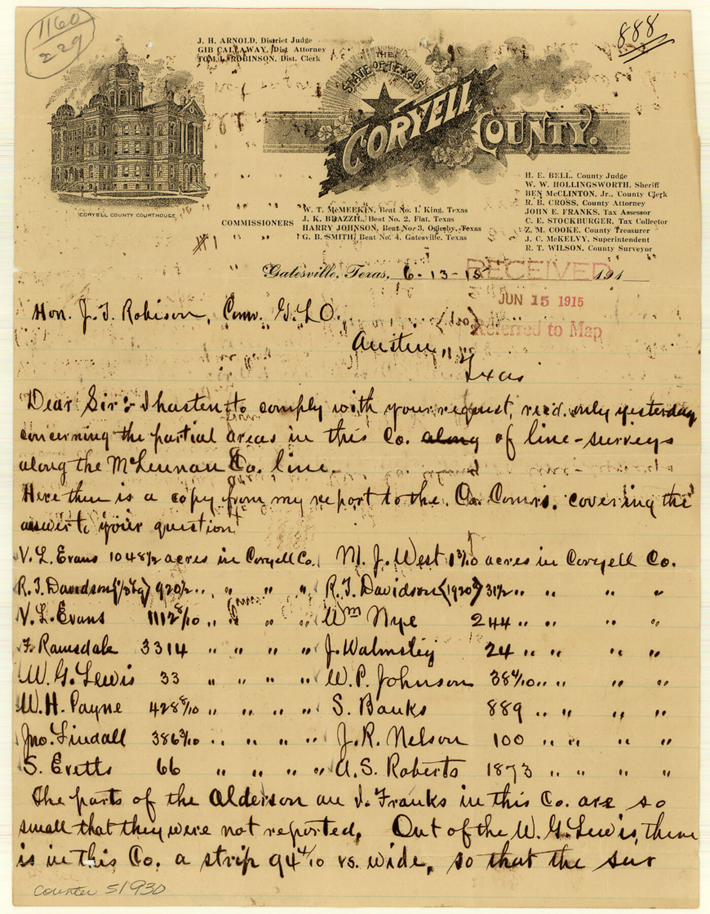
Coryell County Boundary File 4
[Surveyor's Report on acreage along the Coryell-McLennan County line]
-
Map/Doc
51930
-
Collection
General Map Collection
-
Counties
Coryell
-
Subjects
County Boundaries
-
Height x Width
11.2 x 8.7 inches
28.4 x 22.1 cm
Part of: General Map Collection
Jefferson County Sketch File 40

Print $16.00
- Digital $50.00
Jefferson County Sketch File 40
1947
Size 12.3 x 7.9 inches
Map/Doc 28228
Oldham County Working Sketch 6

Print $40.00
- Digital $50.00
Oldham County Working Sketch 6
1981
Size 32.4 x 50.4 inches
Map/Doc 71328
Flight Mission No. BRE-1P, Frame 4, Nueces County

Print $20.00
- Digital $50.00
Flight Mission No. BRE-1P, Frame 4, Nueces County
1956
Size 18.3 x 22.2 inches
Map/Doc 86612
Duval County Rolled Sketch 45

Print $20.00
- Digital $50.00
Duval County Rolled Sketch 45
1982
Size 36.3 x 24.5 inches
Map/Doc 5760
Knox County Boundary File 5a

Print $22.00
- Digital $50.00
Knox County Boundary File 5a
Size 15.6 x 38.5 inches
Map/Doc 65047
Fisher County Sketch File A2

Print $20.00
- Digital $50.00
Fisher County Sketch File A2
1901
Size 35.8 x 31.0 inches
Map/Doc 10450
King County Sketch File 6 (1)

Print $43.00
- Digital $50.00
King County Sketch File 6 (1)
1897
Size 14.5 x 15.7 inches
Map/Doc 29027
Hood County Sketch File 18

Print $4.00
- Digital $50.00
Hood County Sketch File 18
Size 8.4 x 9.6 inches
Map/Doc 26601
Taylor County Sketch File 18

Print $6.00
- Digital $50.00
Taylor County Sketch File 18
Size 11.6 x 7.3 inches
Map/Doc 37813
Flight Mission No. DQO-8K, Frame 11, Galveston County

Print $20.00
- Digital $50.00
Flight Mission No. DQO-8K, Frame 11, Galveston County
1952
Size 18.7 x 22.3 inches
Map/Doc 85134
Williamson County Boundary File 1a

Print $4.00
- Digital $50.00
Williamson County Boundary File 1a
Size 11.0 x 8.4 inches
Map/Doc 59990
Map of Voss, Texas, Coleman County

Print $20.00
- Digital $50.00
Map of Voss, Texas, Coleman County
Size 15.8 x 16.0 inches
Map/Doc 81519
You may also like
Map of Nacogdoches County

Print $20.00
- Digital $50.00
Map of Nacogdoches County
1881
Size 24.5 x 21.8 inches
Map/Doc 4604
Bandera County Working Sketch 11

Print $20.00
- Digital $50.00
Bandera County Working Sketch 11
1928
Size 17.8 x 27.4 inches
Map/Doc 67604
Working Sketch compiled from original field notes showing surveys in Reagan and Irion Counties located by Frank Lerch in 1883 and 1884, also adjacent blocks and surveys (previously located by other surveyors) called for in his Field Notes

Print $20.00
- Digital $50.00
Working Sketch compiled from original field notes showing surveys in Reagan and Irion Counties located by Frank Lerch in 1883 and 1884, also adjacent blocks and surveys (previously located by other surveyors) called for in his Field Notes
1883
Size 35.8 x 20.0 inches
Map/Doc 91749
Flight Mission No. DQO-8K, Frame 45, Galveston County

Print $20.00
- Digital $50.00
Flight Mission No. DQO-8K, Frame 45, Galveston County
1952
Size 18.8 x 22.3 inches
Map/Doc 85152
Tom Green Co.

Print $40.00
- Digital $50.00
Tom Green Co.
1887
Size 43.9 x 111.7 inches
Map/Doc 82063
Presidio County Sketch File 119

Print $14.00
- Digital $50.00
Presidio County Sketch File 119
1996
Size 14.3 x 9.0 inches
Map/Doc 34927
Hutchinson County Rolled Sketch 44-16

Print $20.00
- Digital $50.00
Hutchinson County Rolled Sketch 44-16
2002
Size 24.0 x 36.0 inches
Map/Doc 77552
Travis County

Print $40.00
- Digital $50.00
Travis County
1936
Size 43.2 x 54.6 inches
Map/Doc 63078
Uvalde County Working Sketch 47

Print $20.00
- Digital $50.00
Uvalde County Working Sketch 47
1979
Size 29.7 x 24.8 inches
Map/Doc 72117
The Empresario Grants. Arthur Goodall Wavell, Proposed Expansion

Print $20.00
The Empresario Grants. Arthur Goodall Wavell, Proposed Expansion
2020
Size 16.0 x 21.7 inches
Map/Doc 96427
General Highway Map, Menard County, Texas

Print $20.00
General Highway Map, Menard County, Texas
1961
Size 18.2 x 24.8 inches
Map/Doc 79595
Martin County Working Sketch 10

Print $40.00
- Digital $50.00
Martin County Working Sketch 10
1971
Size 50.0 x 37.4 inches
Map/Doc 70828