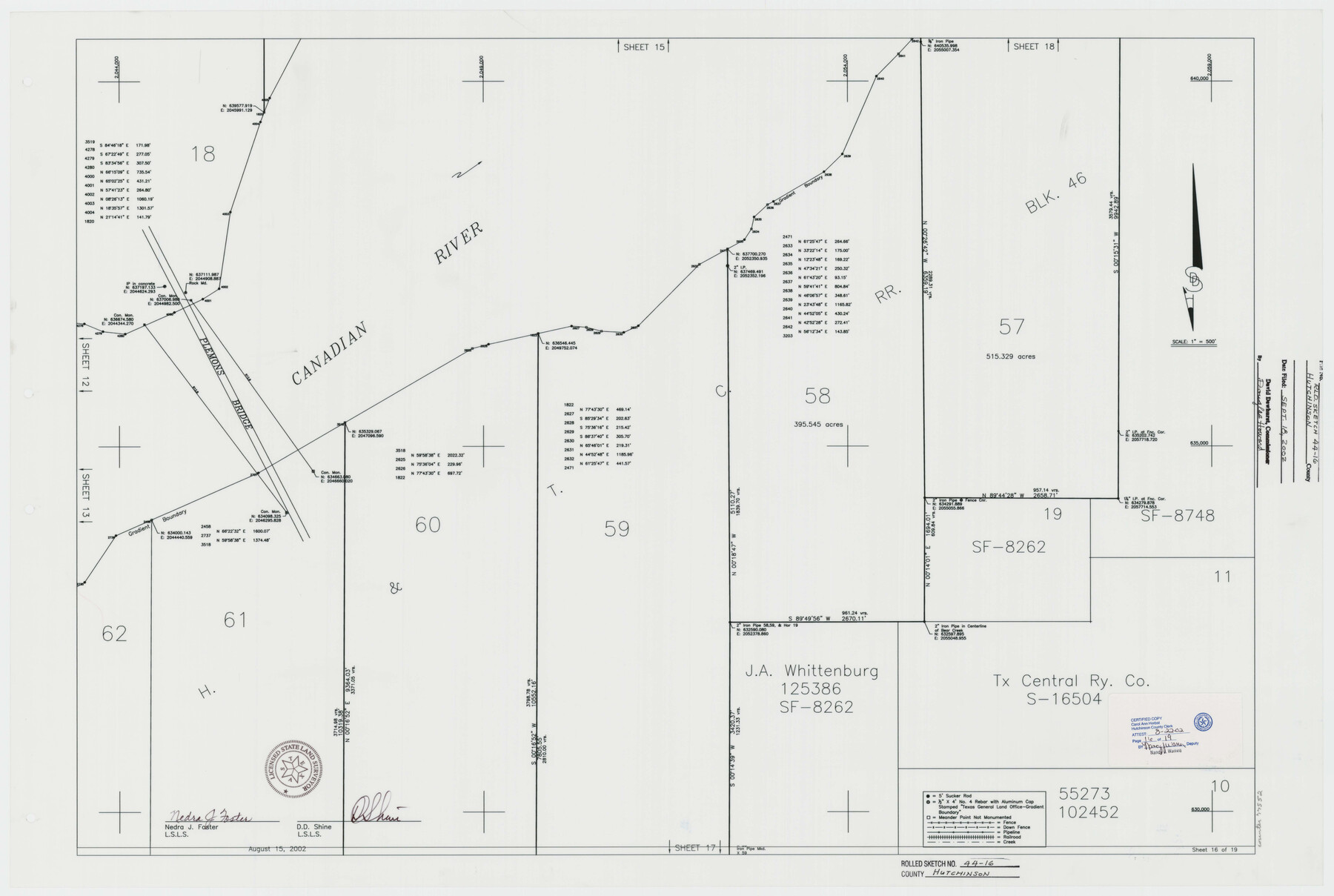
Hutchinson County Rolled Sketch 44-16
Canadian River Survey, Hutchinson County, Texas [Sheet 16 of 19]
-
Map/Doc
77552
-
Collection
General Map Collection
-
Object Dates
2002/8/15 (Creation Date)
2002/9/18 (File Date)
-
People and Organizations
Nedra J. Foster (Surveyor/Engineer)
D.D. Shine (Surveyor/Engineer)
-
Counties
Hutchinson
-
Subjects
Surveying Rolled Sketch
-
Height x Width
24.0 x 36.0 inches
61.0 x 91.4 cm
-
Medium
mylar, print
-
Scale
1" = 500 feet
Part of: General Map Collection
Stephens County Working Sketch 30

Print $20.00
- Digital $50.00
Stephens County Working Sketch 30
1977
Size 26.4 x 15.7 inches
Map/Doc 63973
Crosby County Boundary File 4a

Print $30.00
- Digital $50.00
Crosby County Boundary File 4a
Size 8.8 x 32.8 inches
Map/Doc 52028
[Map of Upshur County]
![[Map of Upshur County]](https://historictexasmaps.com/wmedia_w700/maps/4651.tif.jpg)
Print $20.00
- Digital $50.00
[Map of Upshur County]
1850
Size 25.2 x 17.8 inches
Map/Doc 4651
Denton County Working Sketch 13

Print $20.00
- Digital $50.00
Denton County Working Sketch 13
1962
Size 25.7 x 36.2 inches
Map/Doc 68618
Sketch of Surveys on Peach Point, J. Perry's Property

Print $20.00
- Digital $50.00
Sketch of Surveys on Peach Point, J. Perry's Property
1832
Size 14.0 x 20.6 inches
Map/Doc 219
Culberson County Sketch File 21

Print $20.00
- Digital $50.00
Culberson County Sketch File 21
1937
Size 11.2 x 8.8 inches
Map/Doc 20224
Bastrop County Working Sketch 14

Print $20.00
- Digital $50.00
Bastrop County Working Sketch 14
1984
Size 24.5 x 23.4 inches
Map/Doc 67314
Galveston County Rolled Sketch 45A

Print $20.00
- Digital $50.00
Galveston County Rolled Sketch 45A
1995
Size 19.6 x 29.9 inches
Map/Doc 5979
Nueces County Sketch File 39

Print $8.00
- Digital $50.00
Nueces County Sketch File 39
1934
Size 11.0 x 8.5 inches
Map/Doc 32623
Johnson County Working Sketch 12

Print $20.00
- Digital $50.00
Johnson County Working Sketch 12
1959
Size 22.9 x 22.6 inches
Map/Doc 66625
Flight Mission No. CRC-3R, Frame 91, Chambers County

Print $20.00
- Digital $50.00
Flight Mission No. CRC-3R, Frame 91, Chambers County
1956
Size 18.7 x 22.4 inches
Map/Doc 84829
Kimble County Working Sketch 75

Print $20.00
- Digital $50.00
Kimble County Working Sketch 75
1968
Size 32.0 x 35.7 inches
Map/Doc 70143
You may also like
Calhoun County NRC Article 33.136 Sketch 11

Digital $50.00
Calhoun County NRC Article 33.136 Sketch 11
2023
Map/Doc 97255

Menard County Boundary File 4

Print $12.00
- Digital $50.00
Menard County Boundary File 4
Size 10.9 x 8.6 inches
Map/Doc 57076

Gray County Working Sketch 7

Print $20.00
- Digital $50.00
Gray County Working Sketch 7
1971
Size 41.3 x 28.7 inches
Map/Doc 63238
Section 50, H. & G. N. Block 1

Print $20.00
- Digital $50.00
Section 50, H. & G. N. Block 1
Size 18.8 x 24.9 inches
Map/Doc 90816
McMullen County Working Sketch Graphic Index

Print $40.00
- Digital $50.00
McMullen County Working Sketch Graphic Index
1967
Size 49.4 x 34.6 inches
Map/Doc 76638
Lubbock County Sketch File 12

Print $6.00
- Digital $50.00
Lubbock County Sketch File 12
1933
Size 11.1 x 8.6 inches
Map/Doc 30435
Real County Rolled Sketch 18

Print $20.00
- Digital $50.00
Real County Rolled Sketch 18
Size 22.1 x 28.0 inches
Map/Doc 7467
Jack County Sketch File 36

Print $120.00
- Digital $50.00
Jack County Sketch File 36
1882
Size 16.3 x 11.0 inches
Map/Doc 27575
Shelby County Sketch File 20

Print $20.00
- Digital $50.00
Shelby County Sketch File 20
1879
Size 18.3 x 34.6 inches
Map/Doc 12319
Flight Mission No. BRA-3M, Frame 127, Jefferson County

Print $20.00
- Digital $50.00
Flight Mission No. BRA-3M, Frame 127, Jefferson County
1953
Size 18.5 x 21.6 inches
Map/Doc 85401