Presidio County Sketch File 119
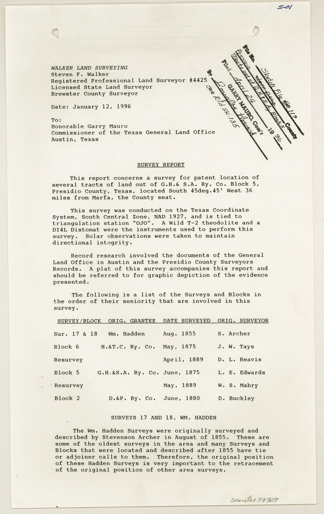
[Survey report on tracts out of G. H. & S. A. R.R. Co. Block 5]
-
Map/Doc
34927
-
Collection
General Map Collection
-
Object Dates
1/12/1996 (Creation Date)
4/24/1996 (File Date)
-
People and Organizations
Steven F. Walker (Surveyor/Engineer)
Stevenson Archer (Surveyor/Engineer)
J.W. Tays (Surveyor/Engineer)
D.L. Reavis (Surveyor/Engineer)
L.E. Edwards (Surveyor/Engineer)
W.S. Mabry (Surveyor/Engineer)
D. Buckley (Surveyor/Engineer)
Michael L. Bamburg (Surveyor/Engineer)
J.P. Dod (Surveyor/Engineer)
F.W. Cook (Surveyor/Engineer)
W.J. Hurd (Surveyor/Engineer)
William H. Rhoome (Surveyor/Engineer)
-
Counties
Presidio
-
Subjects
Surveying Sketch File
-
Height x Width
14.3 x 9.0 inches
36.3 x 22.9 cm
-
Medium
paper, print
-
Comments
See Presidio County Rolled Sketch 135 (7402) for sketch.
-
Features
Chinati Peak
Related maps
Presidio County Rolled Sketch 135

Print $20.00
- Digital $50.00
Presidio County Rolled Sketch 135
1996
Size 38.4 x 26.8 inches
Map/Doc 7402
Part of: General Map Collection
Burnet County Sketch File 38

Print $20.00
- Digital $50.00
Burnet County Sketch File 38
1935
Size 37.8 x 24.5 inches
Map/Doc 11027
Matagorda County Working Sketch 31

Print $20.00
- Digital $50.00
Matagorda County Working Sketch 31
1982
Size 17.2 x 46.9 inches
Map/Doc 70889
Hale County Boundary File 5

Print $4.00
- Digital $50.00
Hale County Boundary File 5
Size 14.1 x 8.7 inches
Map/Doc 54071
Terrell County Working Sketch 57

Print $20.00
- Digital $50.00
Terrell County Working Sketch 57
1959
Size 30.0 x 25.8 inches
Map/Doc 69578
Preliminary survey of the entrance to the Rio Grande, Texas

Print $20.00
- Digital $50.00
Preliminary survey of the entrance to the Rio Grande, Texas
1854
Size 18.3 x 24.5 inches
Map/Doc 73005
Rusk County Working Sketch 15

Print $20.00
- Digital $50.00
Rusk County Working Sketch 15
1972
Size 29.6 x 43.8 inches
Map/Doc 63650
Tyler County Sketch File 6-2

Print $20.00
- Digital $50.00
Tyler County Sketch File 6-2
1861
Size 16.8 x 22.5 inches
Map/Doc 12498
Colorado County Working Sketch 13

Print $20.00
- Digital $50.00
Colorado County Working Sketch 13
1943
Size 37.9 x 23.3 inches
Map/Doc 68113
Jim Wells Co.

Print $20.00
- Digital $50.00
Jim Wells Co.
1966
Size 43.8 x 32.4 inches
Map/Doc 95548
Map of Randall County

Print $20.00
- Digital $50.00
Map of Randall County
1893
Size 26.5 x 20.0 inches
Map/Doc 73338
Val Verde County Working Sketch 54

Print $20.00
- Digital $50.00
Val Verde County Working Sketch 54
1956
Size 24.0 x 20.4 inches
Map/Doc 72189
Coast Chart No. 210 Aransas Pass and Corpus Christi Bay with the coast to latitude 27° 12' Texas

Print $20.00
- Digital $50.00
Coast Chart No. 210 Aransas Pass and Corpus Christi Bay with the coast to latitude 27° 12' Texas
1887
Size 27.6 x 18.3 inches
Map/Doc 72790
You may also like
Eastland County Sketch File 5

Print $4.00
- Digital $50.00
Eastland County Sketch File 5
Size 6.4 x 7.1 inches
Map/Doc 21570
Orange County Working Sketch 45

Print $20.00
- Digital $50.00
Orange County Working Sketch 45
1982
Size 25.6 x 24.2 inches
Map/Doc 71377
Johnson County Sketch File 10

Print $4.00
- Digital $50.00
Johnson County Sketch File 10
1859
Size 10.1 x 8.0 inches
Map/Doc 28443
Crockett County Rolled Sketch 28

Print $20.00
- Digital $50.00
Crockett County Rolled Sketch 28
1884
Size 42.5 x 25.8 inches
Map/Doc 5587
Swisher County Sketch File 7

Print $32.00
- Digital $50.00
Swisher County Sketch File 7
1904
Size 9.0 x 8.4 inches
Map/Doc 37622
Val Verde County Working Sketch 91

Print $20.00
- Digital $50.00
Val Verde County Working Sketch 91
1976
Size 46.5 x 42.8 inches
Map/Doc 72226
Flight Mission No. DAG-17K, Frame 124, Matagorda County

Print $20.00
- Digital $50.00
Flight Mission No. DAG-17K, Frame 124, Matagorda County
1952
Size 18.6 x 22.3 inches
Map/Doc 86344
Bexar County Rolled Sketch 4

Print $20.00
- Digital $50.00
Bexar County Rolled Sketch 4
Size 24.3 x 36.8 inches
Map/Doc 5137
League 206, Ochiltree County School Land, Bailey and Lamb Counties, Texas

Print $20.00
- Digital $50.00
League 206, Ochiltree County School Land, Bailey and Lamb Counties, Texas
1954
Size 36.9 x 25.0 inches
Map/Doc 92537
[C. C. S. D. & R. G. N. G. RR. Co. Block G, Waxahachie Tap RR. Co. Block G and D. & W. RR. Co. Block H]
![90859, [C. C. S. D. & R. G. N. G. RR. Co. Block G, Waxahachie Tap RR. Co. Block G and D. & W. RR. Co. Block H], Twichell Survey Records](https://historictexasmaps.com/wmedia_w700/maps/90859-2.tif.jpg)
Print $20.00
- Digital $50.00
[C. C. S. D. & R. G. N. G. RR. Co. Block G, Waxahachie Tap RR. Co. Block G and D. & W. RR. Co. Block H]
1915
Size 22.6 x 11.4 inches
Map/Doc 90859
Foard County Sketch File 35

Print $20.00
- Digital $50.00
Foard County Sketch File 35
Size 25.2 x 24.8 inches
Map/Doc 6067
Nacogdoches County Sketch File 13

Print $6.00
- Digital $50.00
Nacogdoches County Sketch File 13
1883
Size 14.2 x 8.7 inches
Map/Doc 32256