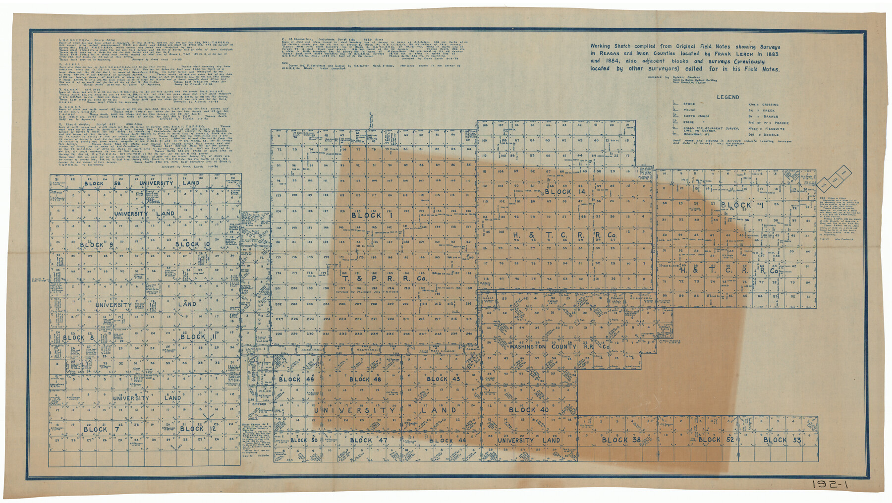
Working Sketch compiled from original field notes showing surveys in Reagan and Irion Counties located by Frank Lerch in 1883 and 1884, also adjacent blocks and surveys (previously located by other surveyors) called for in his Field Notes
192-1
-
Map/Doc
91749
-
Collection
Twichell Survey Records
-
Object Dates
1883-1884 (Creation Date)
-
People and Organizations
Frank Lerch (Surveyor/Engineer)
Sylvan Sanders (Compiler)
-
Counties
Reagan Irion
-
Height x Width
35.8 x 20.0 inches
90.9 x 50.8 cm
Part of: Twichell Survey Records
Town of Ropes Hockley County, Texas

Print $20.00
- Digital $50.00
Town of Ropes Hockley County, Texas
Size 29.5 x 29.8 inches
Map/Doc 92223
McMullen County

Print $20.00
- Digital $50.00
McMullen County
1889
Size 12.4 x 16.4 inches
Map/Doc 92957
[Part of Connected map of Stephen F. Austin's Colony on file at the GLO]
![90119, [Part of Connected map of Stephen F. Austin's Colony on file at the GLO], Twichell Survey Records](https://historictexasmaps.com/wmedia_w700/maps/90119-1.tif.jpg)
Print $20.00
- Digital $50.00
[Part of Connected map of Stephen F. Austin's Colony on file at the GLO]
1923
Size 18.5 x 18.1 inches
Map/Doc 90119
Well Locations in Gaines County, Texas for American Liberty Oil Co.

Print $20.00
- Digital $50.00
Well Locations in Gaines County, Texas for American Liberty Oil Co.
Size 20.1 x 22.2 inches
Map/Doc 92855
Rattlesnake Pasture in Howard and Borden Counties

Print $20.00
- Digital $50.00
Rattlesnake Pasture in Howard and Borden Counties
1908
Size 34.2 x 29.9 inches
Map/Doc 91204
Map of C. W. Post's Land in Hockley County, Texas

Print $20.00
- Digital $50.00
Map of C. W. Post's Land in Hockley County, Texas
Size 24.7 x 15.7 inches
Map/Doc 91095
[Townships 4N and 5N]
![90633, [Townships 4N and 5N], Twichell Survey Records](https://historictexasmaps.com/wmedia_w700/90633.tif.jpg)
Print $20.00
- Digital $50.00
[Townships 4N and 5N]
Size 23.6 x 27.1 inches
Map/Doc 90633
[PSL Blocks B8-B9, B13-B18 and B22]
![91963, [PSL Blocks B8-B9, B13-B18 and B22], Twichell Survey Records](https://historictexasmaps.com/wmedia_w700/maps/91963-1.tif.jpg)
Print $20.00
- Digital $50.00
[PSL Blocks B8-B9, B13-B18 and B22]
Size 19.8 x 27.2 inches
Map/Doc 91963

[E. T. Ry. Blk. 1]
![89796, [E. T. Ry. Blk. 1], Twichell Survey Records](https://historictexasmaps.com/wmedia_w700/maps/89796-1.tif.jpg)
Print $40.00
- Digital $50.00
[E. T. Ry. Blk. 1]
Size 41.1 x 50.4 inches
Map/Doc 89796
[Sketch showing correct location of the North and East lines of the Nave McCord pasture fence]
![90896, [Sketch showing correct location of the North and East lines of the Nave McCord pasture fence], Twichell Survey Records](https://historictexasmaps.com/wmedia_w700/maps/90896-1.tif.jpg)
Print $20.00
- Digital $50.00
[Sketch showing correct location of the North and East lines of the Nave McCord pasture fence]
1900
Size 20.3 x 11.8 inches
Map/Doc 90896
Working Sketch Compiled From Original Field Notes Showing Surveys in Reagan and Irion Counties

Print $20.00
- Digital $50.00
Working Sketch Compiled From Original Field Notes Showing Surveys in Reagan and Irion Counties
Size 36.2 x 20.2 inches
Map/Doc 92331
You may also like
Galveston County Aerial Photograph Index Sheet 2

Print $20.00
- Digital $50.00
Galveston County Aerial Photograph Index Sheet 2
1953
Size 21.2 x 19.5 inches
Map/Doc 83693
Double Lakes No. 1 T-Ranch Lynn County, Texas

Print $20.00
- Digital $50.00
Double Lakes No. 1 T-Ranch Lynn County, Texas
Size 36.8 x 31.8 inches
Map/Doc 93216
Nueces County Rolled Sketch 45

Print $20.00
- Digital $50.00
Nueces County Rolled Sketch 45
1941
Size 44.3 x 43.7 inches
Map/Doc 9603
Cameron County Rolled Sketch Z8

Print $20.00
- Digital $50.00
Cameron County Rolled Sketch Z8
1937
Size 30.3 x 34.5 inches
Map/Doc 5406

Bandera County Boundary File 4b

Print $16.00
- Digital $50.00
Bandera County Boundary File 4b
Size 13.0 x 8.1 inches
Map/Doc 50281
Runnels County Working Sketch 2

Print $20.00
- Digital $50.00
Runnels County Working Sketch 2
Size 19.8 x 29.4 inches
Map/Doc 63598
Fractional Township No. 8 South Range No. 18 East of the Indian Meridian, Indian Territory

Print $20.00
- Digital $50.00
Fractional Township No. 8 South Range No. 18 East of the Indian Meridian, Indian Territory
1897
Size 19.2 x 24.3 inches
Map/Doc 75233
Map of Schleicher Co.

Print $20.00
- Digital $50.00
Map of Schleicher Co.
1891
Size 24.4 x 32.5 inches
Map/Doc 63024
Presidio County Rolled Sketch 53

Print $20.00
- Digital $50.00
Presidio County Rolled Sketch 53
1911
Size 14.3 x 21.7 inches
Map/Doc 7345
Freestone County Working Sketch 30

Print $20.00
- Digital $50.00
Freestone County Working Sketch 30
Size 29.5 x 37.2 inches
Map/Doc 69272
Potter County Boundary File 3b

Print $12.00
- Digital $50.00
Potter County Boundary File 3b
Size 9.8 x 6.4 inches
Map/Doc 57979