Brewster County Rolled Sketch 11A
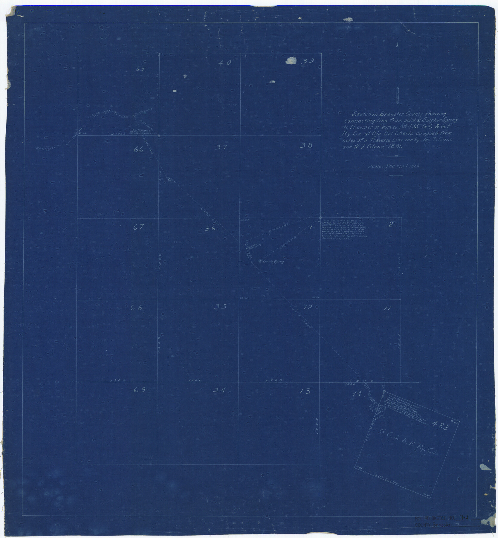
Sketch in Brewster County showing connecting line from point at Sulphur Spring to N. corner of survey no. 483, G. C. & S. F. Ry. Co. at Ojo Del Cheris, compiled from notes of a Traverse Line run by Jno. T. Gano and W.J. Glenn
-
Map/Doc
5192
-
Collection
General Map Collection
-
Object Dates
1881 (Creation Date)
-
People and Organizations
Jno. T. Gano (Surveyor/Engineer)
W.J. Glenn (Surveyor/Engineer)
-
Counties
Brewster
-
Subjects
Surveying Rolled Sketch
-
Height x Width
24.9 x 23.0 inches
63.2 x 58.4 cm
-
Medium
blueprint/diazo
-
Scale
1" = 500 varas
-
Comments
Copy of Brewster County Rolled Sketch 11 (5191).
Related maps
Brewster County Rolled Sketch 11

Print $20.00
- Digital $50.00
Brewster County Rolled Sketch 11
1881
Size 24.9 x 23.1 inches
Map/Doc 5191
Part of: General Map Collection
Township No. 2 South Range No. 21 West of the Indian Meridian

Print $20.00
- Digital $50.00
Township No. 2 South Range No. 21 West of the Indian Meridian
1875
Size 19.3 x 24.4 inches
Map/Doc 75177
Flight Mission No. CRC-2R, Frame 198, Chambers County

Print $20.00
- Digital $50.00
Flight Mission No. CRC-2R, Frame 198, Chambers County
1956
Size 18.7 x 22.4 inches
Map/Doc 84776
Navarro County Sketch File 21

Print $4.00
- Digital $50.00
Navarro County Sketch File 21
1859
Size 9.0 x 8.4 inches
Map/Doc 32350
Comanche County Working Sketch 30

Print $20.00
- Digital $50.00
Comanche County Working Sketch 30
1988
Size 18.8 x 28.2 inches
Map/Doc 68164
Panola County Sketch File 4

Print $4.00
- Digital $50.00
Panola County Sketch File 4
1860
Size 8.9 x 8.9 inches
Map/Doc 33449
Map of Nacogdoches County

Print $40.00
- Digital $50.00
Map of Nacogdoches County
1846
Size 83.7 x 76.1 inches
Map/Doc 82243
Crockett County Sketch File 27

Print $10.00
- Digital $50.00
Crockett County Sketch File 27
1883
Size 9.1 x 14.5 inches
Map/Doc 19717
Roberts County Rolled Sketch 1

Print $20.00
- Digital $50.00
Roberts County Rolled Sketch 1
Size 18.4 x 23.5 inches
Map/Doc 7510
Nueces County Rolled Sketch 116

Print $40.00
- Digital $50.00
Nueces County Rolled Sketch 116
Size 29.6 x 58.3 inches
Map/Doc 7141
Trinity County Working Sketch 12

Print $20.00
- Digital $50.00
Trinity County Working Sketch 12
1950
Size 46.6 x 36.9 inches
Map/Doc 69461
Liberty County Working Sketch 28

Print $20.00
- Digital $50.00
Liberty County Working Sketch 28
1942
Size 22.4 x 23.2 inches
Map/Doc 70487
Outer Continental Shelf Leasing Maps (Louisiana Offshore Operations)

Print $20.00
- Digital $50.00
Outer Continental Shelf Leasing Maps (Louisiana Offshore Operations)
1959
Size 17.8 x 14.0 inches
Map/Doc 76100
You may also like
Asher and Adams' Texas

Print $20.00
- Digital $50.00
Asher and Adams' Texas
1871
Size 25.4 x 18.5 inches
Map/Doc 93788
Mrs. Minnie Slaughter Veal's Subdivision of C. C. Slaughter Cattle Company Division

Print $20.00
- Digital $50.00
Mrs. Minnie Slaughter Veal's Subdivision of C. C. Slaughter Cattle Company Division
Size 26.5 x 20.6 inches
Map/Doc 92510
Travis County Sketch File 46

Print $20.00
- Digital $50.00
Travis County Sketch File 46
1939
Size 21.0 x 21.2 inches
Map/Doc 12468
Hardin County Sketch File 49

Print $4.00
- Digital $50.00
Hardin County Sketch File 49
1904
Size 14.5 x 8.8 inches
Map/Doc 25202
Bird's Eye View of Gatesville, Coryell County, Texas

Print $20.00
Bird's Eye View of Gatesville, Coryell County, Texas
1884
Size 15.7 x 24.2 inches
Map/Doc 89088
Galveston County NRC Article 33.136 Location Key Sheet

Print $20.00
- Digital $50.00
Galveston County NRC Article 33.136 Location Key Sheet
1994
Size 27.0 x 21.8 inches
Map/Doc 77019
Menard County Rolled Sketch 12

Print $20.00
- Digital $50.00
Menard County Rolled Sketch 12
Size 14.4 x 21.7 inches
Map/Doc 6758
Upton County Sketch File 10

Print $18.00
- Digital $50.00
Upton County Sketch File 10
1919
Size 13.5 x 8.7 inches
Map/Doc 38839
Flight Mission No. CRC-3R, Frame 202, Chambers County

Print $20.00
- Digital $50.00
Flight Mission No. CRC-3R, Frame 202, Chambers County
1956
Size 18.7 x 22.4 inches
Map/Doc 84857
Map of Terry County

Print $20.00
- Digital $50.00
Map of Terry County
1901
Size 43.1 x 39.8 inches
Map/Doc 16892
Pecos County Rolled Sketch 30

Print $20.00
- Digital $50.00
Pecos County Rolled Sketch 30
1890
Size 39.2 x 30.7 inches
Map/Doc 9691
Leon County Rolled Sketch 9

Print $40.00
- Digital $50.00
Leon County Rolled Sketch 9
1960
Size 50.1 x 35.2 inches
Map/Doc 9430