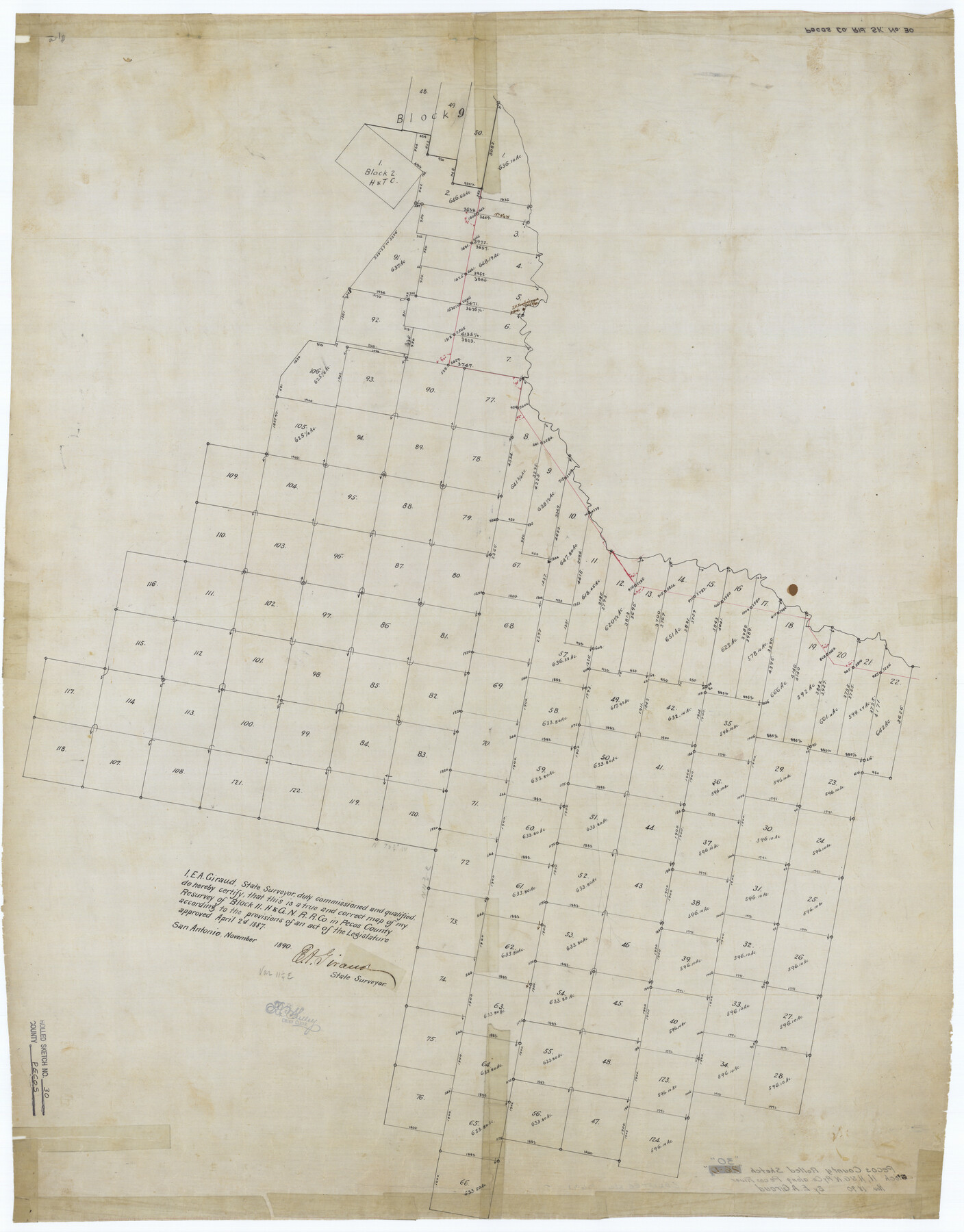
Pecos County Rolled Sketch 30
[Sketch of resurvey of Block 11, H. & G. N. R.R. Co. in Pecos County]
-
Map/Doc
9691
-
Collection
General Map Collection
-
Object Dates
1890 (Creation Date)
-
People and Organizations
E.A. Giraud (Surveyor/Engineer)
-
Counties
Pecos
-
Subjects
Surveying Rolled Sketch
-
Height x Width
39.2 x 30.7 inches
99.6 x 78.0 cm
-
Medium
linen, manuscript
Part of: General Map Collection
Webb County Sketch File A

Print $20.00
- Digital $50.00
Webb County Sketch File A
1891
Size 35.3 x 17.1 inches
Map/Doc 12603
[Surveys in the Fannin District: Bois d'Arc Creek, Sulphur Creek]
![263, [Surveys in the Fannin District: Bois d'Arc Creek, Sulphur Creek], General Map Collection](https://historictexasmaps.com/wmedia_w700/maps/263.tif.jpg)
Print $2.00
- Digital $50.00
[Surveys in the Fannin District: Bois d'Arc Creek, Sulphur Creek]
1844
Size 7.9 x 7.9 inches
Map/Doc 263
Freestone County

Print $20.00
- Digital $50.00
Freestone County
1918
Size 46.8 x 39.8 inches
Map/Doc 4702
Howard County

Print $20.00
- Digital $50.00
Howard County
1922
Size 40.3 x 34.6 inches
Map/Doc 77318
Culberson County Working Sketch 72

Print $40.00
- Digital $50.00
Culberson County Working Sketch 72
1975
Size 50.1 x 34.2 inches
Map/Doc 68526
Lampasas County Working Sketch 13

Print $20.00
- Digital $50.00
Lampasas County Working Sketch 13
1973
Size 34.4 x 27.7 inches
Map/Doc 70290
Eastland County Sketch File 20

Print $62.00
- Digital $50.00
Eastland County Sketch File 20
1987
Size 9.1 x 11.3 inches
Map/Doc 21609
[Galveston, Harrisburg & San Antonio from El Paso-Presidio county boundary to Presidio-Pecos county boundary]
![64718, [Galveston, Harrisburg & San Antonio from El Paso-Presidio county boundary to Presidio-Pecos county boundary], General Map Collection](https://historictexasmaps.com/wmedia_w700/maps/64718.tif.jpg)
Print $40.00
- Digital $50.00
[Galveston, Harrisburg & San Antonio from El Paso-Presidio county boundary to Presidio-Pecos county boundary]
Size 106.1 x 44.3 inches
Map/Doc 64718
General Chart of the Coast No. XXI Gulf Coast from Galveston to the Rio Grande

Print $20.00
- Digital $50.00
General Chart of the Coast No. XXI Gulf Coast from Galveston to the Rio Grande
1883
Size 27.1 x 18.2 inches
Map/Doc 72730
Foard County Rolled Sketch 12

Print $20.00
- Digital $50.00
Foard County Rolled Sketch 12
1945
Size 26.8 x 19.7 inches
Map/Doc 5886
Gregg County Sketch File 10

Print $20.00
- Digital $50.00
Gregg County Sketch File 10
1932
Size 35.1 x 26.0 inches
Map/Doc 11588
Bosque County

Print $20.00
- Digital $50.00
Bosque County
1945
Size 42.6 x 33.0 inches
Map/Doc 77215
You may also like
Gonzales County

Print $40.00
- Digital $50.00
Gonzales County
1920
Size 41.0 x 51.2 inches
Map/Doc 1841
Potter County Sketch File 15

Print $20.00
- Digital $50.00
Potter County Sketch File 15
Size 19.5 x 21.1 inches
Map/Doc 12201
Flight Mission No. BQY-4M, Frame 65, Harris County

Print $20.00
- Digital $50.00
Flight Mission No. BQY-4M, Frame 65, Harris County
1953
Size 18.7 x 22.4 inches
Map/Doc 85274
Howard County Sketch File 6

Print $44.00
- Digital $50.00
Howard County Sketch File 6
1929
Size 18.6 x 14.4 inches
Map/Doc 26861
Anderson County Working Sketch 33

Print $20.00
- Digital $50.00
Anderson County Working Sketch 33
1966
Size 30.8 x 29.9 inches
Map/Doc 67033
Map of Blocks No. 46 and 47 made in the name of Houston and Texas Central RR. Co. in Oldham District

Print $20.00
- Digital $50.00
Map of Blocks No. 46 and 47 made in the name of Houston and Texas Central RR. Co. in Oldham District
1884
Size 40.8 x 27.0 inches
Map/Doc 91818
Medina County Working Sketch 16

Print $20.00
- Digital $50.00
Medina County Working Sketch 16
1979
Size 27.1 x 28.2 inches
Map/Doc 70931
Kerr County Working Sketch 2

Print $20.00
- Digital $50.00
Kerr County Working Sketch 2
1926
Size 18.6 x 17.9 inches
Map/Doc 70033
Bailey County Rolled Sketch 7

Print $40.00
- Digital $50.00
Bailey County Rolled Sketch 7
1941
Size 67.7 x 44.8 inches
Map/Doc 8438
Laguna Madre, T-9211

Print $20.00
- Digital $50.00
Laguna Madre, T-9211
Size 33.0 x 31.1 inches
Map/Doc 73602
Nueces County Rolled Sketch 43B

Print $20.00
- Digital $50.00
Nueces County Rolled Sketch 43B
Size 28.0 x 36.5 inches
Map/Doc 6885
The Republic County of Colorado. December 29, 1845

Print $20.00
The Republic County of Colorado. December 29, 1845
2020
Size 18.4 x 21.7 inches
Map/Doc 96127