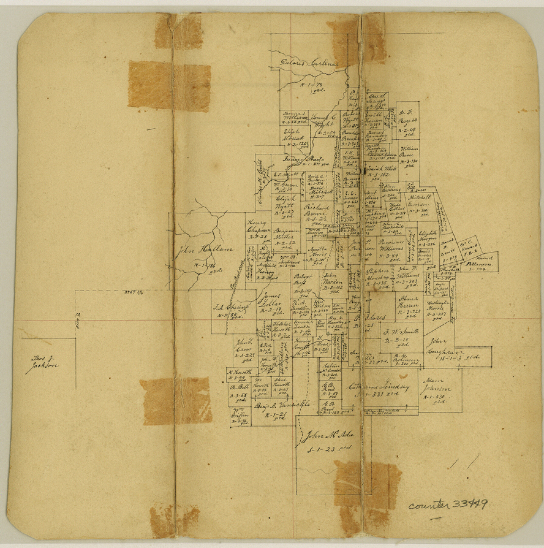
Panola County Sketch File 4
[Sketch of surveys in west part of Panola County and east part of Rusk County]
-
Map/Doc
33449
-
Collection
General Map Collection
-
Object Dates
11/28/1860 (Creation Date)
11/28/1860 (File Date)
-
Counties
Panola Rusk
-
Subjects
Surveying Sketch File
-
Height x Width
8.9 x 8.9 inches
22.6 x 22.6 cm
-
Medium
paper, manuscript
-
Features
Gun Point Creek
Part of: General Map Collection
Flight Mission No. DIX-5P, Frame 140, Aransas County

Print $20.00
- Digital $50.00
Flight Mission No. DIX-5P, Frame 140, Aransas County
1956
Size 17.8 x 18.5 inches
Map/Doc 83801
Howard County Sketch File 15

Print $6.00
- Digital $50.00
Howard County Sketch File 15
Size 11.2 x 8.8 inches
Map/Doc 26875
Greer County Sketch File 4

Print $4.00
- Digital $50.00
Greer County Sketch File 4
1883
Size 8.6 x 5.5 inches
Map/Doc 24519
Cochran County Rolled Sketch 6

Print $20.00
- Digital $50.00
Cochran County Rolled Sketch 6
2025
Size 20.5 x 28.2 inches
Map/Doc 97417
Martin County Sketch File 13

Print $4.00
- Digital $50.00
Martin County Sketch File 13
1941
Size 14.2 x 9.1 inches
Map/Doc 30669
Cottle County Working Sketch 14B

Print $20.00
- Digital $50.00
Cottle County Working Sketch 14B
1963
Size 35.2 x 41.6 inches
Map/Doc 61795
Hays County Working Sketch 15

Print $40.00
- Digital $50.00
Hays County Working Sketch 15
1965
Size 39.8 x 51.6 inches
Map/Doc 66089
Jefferson County Sketch File 21

Print $10.00
- Digital $50.00
Jefferson County Sketch File 21
Size 8.6 x 6.6 inches
Map/Doc 28171
Reagan County Working Sketch 29

Print $40.00
- Digital $50.00
Reagan County Working Sketch 29
1963
Size 34.3 x 66.4 inches
Map/Doc 71871
Lavaca County Working Sketch 18

Print $20.00
- Digital $50.00
Lavaca County Working Sketch 18
1979
Size 37.0 x 20.3 inches
Map/Doc 70371
Flight Mission No. DQN-5K, Frame 39, Calhoun County

Print $20.00
- Digital $50.00
Flight Mission No. DQN-5K, Frame 39, Calhoun County
1953
Size 18.5 x 22.1 inches
Map/Doc 84387
Upton County Working Sketch 3

Print $20.00
- Digital $50.00
Upton County Working Sketch 3
Size 21.4 x 33.8 inches
Map/Doc 69499
You may also like
Crockett County Working Sketch 3

Print $20.00
- Digital $50.00
Crockett County Working Sketch 3
Size 21.5 x 16.5 inches
Map/Doc 68336
Crockett County Sketch File 57

Print $22.00
- Digital $50.00
Crockett County Sketch File 57
Size 12.2 x 8.9 inches
Map/Doc 19832
Yoakum County Sketch File 1

Print $10.00
- Digital $50.00
Yoakum County Sketch File 1
Size 9.4 x 8.3 inches
Map/Doc 40697
Wise County Sketch File 41

Print $4.00
- Digital $50.00
Wise County Sketch File 41
1875
Size 12.8 x 8.1 inches
Map/Doc 40599
Crockett County Rolled Sketch 69

Print $40.00
- Digital $50.00
Crockett County Rolled Sketch 69
1949
Size 39.4 x 54.8 inches
Map/Doc 8721
Flight Mission No. CRK-5P, Frame 161, Refugio County

Print $20.00
- Digital $50.00
Flight Mission No. CRK-5P, Frame 161, Refugio County
1956
Size 18.5 x 22.4 inches
Map/Doc 86942
Map of subdivision of submerged land in the Gulf of Mexico fronting on Matagorda Island and Peninsula

Print $40.00
- Digital $50.00
Map of subdivision of submerged land in the Gulf of Mexico fronting on Matagorda Island and Peninsula
1940
Size 22.8 x 76.5 inches
Map/Doc 2932
Colorado County Working Sketch 33

Print $20.00
- Digital $50.00
Colorado County Working Sketch 33
1988
Size 38.7 x 32.4 inches
Map/Doc 68133
Sketch G Showing the Progress of the Survey in Section VII From 1849 to 1852

Print $20.00
- Digital $50.00
Sketch G Showing the Progress of the Survey in Section VII From 1849 to 1852
1852
Size 13.6 x 25.8 inches
Map/Doc 97219
Edwards County Sketch File 51

Print $32.00
- Digital $50.00
Edwards County Sketch File 51
1965
Size 11.6 x 9.0 inches
Map/Doc 21800
Atascosa County Sketch File 14

Print $40.00
- Digital $50.00
Atascosa County Sketch File 14
1870
Size 12.5 x 15.0 inches
Map/Doc 13773
Copy of Surveyor's Field Book, Morris Browning - In Blocks 7, 5 & 4, I&GNRRCo., Hutchinson and Carson Counties, Texas

Print $2.00
- Digital $50.00
Copy of Surveyor's Field Book, Morris Browning - In Blocks 7, 5 & 4, I&GNRRCo., Hutchinson and Carson Counties, Texas
1888
Size 6.9 x 8.8 inches
Map/Doc 62264