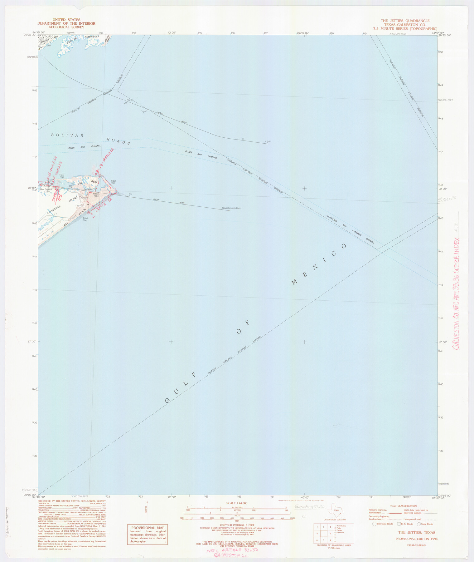
Galveston County NRC Article 33.136 Location Key Sheet
Smith Point Quadrangle
-
Map/Doc
77019
-
Collection
General Map Collection
-
Object Dates
1994 (Creation Date)
-
People and Organizations
U. S. Geological Survey (Publisher)
U. S. Geological Survey (Printer)
-
Counties
Galveston
-
Subjects
Surveying CBS
-
Height x Width
27.0 x 21.8 inches
68.6 x 55.2 cm
Part of: General Map Collection
Jefferson County NRC Article 33.136 Sketch 3

Print $22.00
- Digital $50.00
Jefferson County NRC Article 33.136 Sketch 3
2003
Size 22.7 x 33.9 inches
Map/Doc 78610
Map showing eight tidal areas in Oso Bay and Oso Creek, Nueces County, Texas offered for Mineral Development

Print $20.00
- Digital $50.00
Map showing eight tidal areas in Oso Bay and Oso Creek, Nueces County, Texas offered for Mineral Development
1936
Size 17.9 x 29.7 inches
Map/Doc 2067
Burleson County

Print $20.00
- Digital $50.00
Burleson County
1884
Size 21.9 x 25.2 inches
Map/Doc 3349
Zavala County Working Sketch 15

Print $20.00
- Digital $50.00
Zavala County Working Sketch 15
1977
Size 27.8 x 23.9 inches
Map/Doc 62090
Harris County Sketch File 24

Print $8.00
- Digital $50.00
Harris County Sketch File 24
Size 8.8 x 8.0 inches
Map/Doc 25385
Flight Mission No. DAH-17M, Frame 18, Orange County

Print $20.00
- Digital $50.00
Flight Mission No. DAH-17M, Frame 18, Orange County
1953
Size 18.5 x 22.6 inches
Map/Doc 86881
Grimes County Working Sketch 16

Print $20.00
- Digital $50.00
Grimes County Working Sketch 16
1995
Size 41.6 x 33.1 inches
Map/Doc 63307
San Patricio County Working Sketch 3

Print $20.00
- Digital $50.00
San Patricio County Working Sketch 3
1917
Size 22.2 x 42.7 inches
Map/Doc 63765
Hood County Working Sketch 27

Print $20.00
- Digital $50.00
Hood County Working Sketch 27
1995
Size 24.6 x 38.0 inches
Map/Doc 66221
Map of the World on a Globular Projection to illustrate Olney's school geography

Print $20.00
- Digital $50.00
Map of the World on a Globular Projection to illustrate Olney's school geography
1844
Size 12.1 x 19.0 inches
Map/Doc 93535
Flight Mission No. BRA-8M, Frame 118, Jefferson County

Print $20.00
- Digital $50.00
Flight Mission No. BRA-8M, Frame 118, Jefferson County
1953
Size 18.6 x 22.3 inches
Map/Doc 85614
Brewster County Rolled Sketch K

Print $20.00
- Digital $50.00
Brewster County Rolled Sketch K
1884
Size 19.6 x 13.9 inches
Map/Doc 5321
You may also like
Map of Leon County

Print $20.00
- Digital $50.00
Map of Leon County
1871
Size 23.6 x 21.2 inches
Map/Doc 3808
[Map of Lynn County]
![4586, [Map of Lynn County], General Map Collection](https://historictexasmaps.com/wmedia_w700/maps/4586-1.tif.jpg)
Print $20.00
- Digital $50.00
[Map of Lynn County]
Size 22.4 x 17.8 inches
Map/Doc 4586
Harrison County Rolled Sketch 4

Print $20.00
- Digital $50.00
Harrison County Rolled Sketch 4
1938
Size 28.2 x 34.9 inches
Map/Doc 6150
Kimble County Working Sketch 58

Print $20.00
- Digital $50.00
Kimble County Working Sketch 58
1959
Size 12.8 x 26.4 inches
Map/Doc 70126
Howard County Sketch File 16

Print $40.00
- Digital $50.00
Howard County Sketch File 16
1947
Size 19.7 x 9.0 inches
Map/Doc 26878
Flight Mission No. DCL-7C, Frame 67, Kenedy County

Print $20.00
- Digital $50.00
Flight Mission No. DCL-7C, Frame 67, Kenedy County
1943
Size 15.5 x 15.3 inches
Map/Doc 86053
Wilbarger Co.

Print $40.00
- Digital $50.00
Wilbarger Co.
1907
Size 49.0 x 39.3 inches
Map/Doc 16927
Starr County Sketch File 20a

Print $12.00
- Digital $50.00
Starr County Sketch File 20a
1892
Size 14.3 x 8.8 inches
Map/Doc 36883
Foard County Sketch File 16

Print $6.00
- Digital $50.00
Foard County Sketch File 16
1885
Size 14.2 x 8.7 inches
Map/Doc 22825
South Part of El Paso Co.

Print $20.00
- Digital $50.00
South Part of El Paso Co.
1977
Size 36.5 x 47.8 inches
Map/Doc 95491
Sketch Showing all that Portion of Block 24 North of Santa Fe R. R. Right-of-Way in Original Town of Lubbock

Print $20.00
- Digital $50.00
Sketch Showing all that Portion of Block 24 North of Santa Fe R. R. Right-of-Way in Original Town of Lubbock
1925
Size 26.9 x 34.4 inches
Map/Doc 92809
Kimble County Working Sketch 32

Print $20.00
- Digital $50.00
Kimble County Working Sketch 32
1944
Size 22.6 x 16.0 inches
Map/Doc 70100