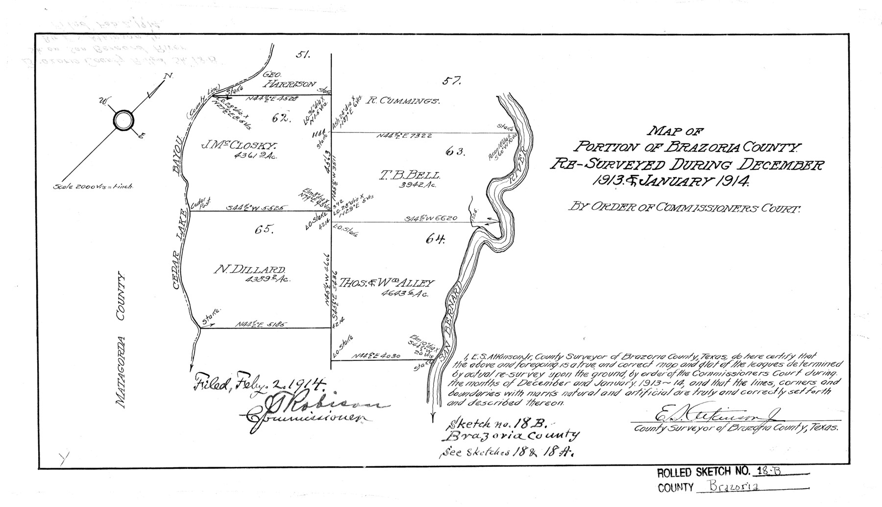
Brazoria County Rolled Sketch 18B
Map of portion of Brazoria County re-surveyed during December 1913 & January 1914 by order of Commissioner's Court
-
Map/Doc
5165
-
Collection
General Map Collection
-
Object Dates
1/1914 (Creation Date)
2/2/1914 (File Date)
-
People and Organizations
E.S. Atkinson, Jr. (Surveyor/Engineer)
-
Counties
Brazoria
-
Subjects
Surveying Rolled Sketch
-
Height x Width
10.0 x 17.3 inches
25.4 x 43.9 cm
-
Scale
1" = 2000 varas
-
Comments
See Bowie County Rolled Sketch 18 (5163) and Bowie County Rolled Sketch 18A (5164) for related sketches.
See also GSC 000002:1 for correspondence regarding the filing of corrected field notes.
Related maps
Brazoria County Rolled Sketch 18

Print $20.00
- Digital $50.00
Brazoria County Rolled Sketch 18
Size 28.0 x 22.5 inches
Map/Doc 5163
Brazoria County Rolled Sketch 18A

Print $20.00
- Digital $50.00
Brazoria County Rolled Sketch 18A
1913
Size 28.3 x 25.1 inches
Map/Doc 5164
Part of: General Map Collection
Kimble County Working Sketch 40

Print $40.00
- Digital $50.00
Kimble County Working Sketch 40
1948
Size 53.0 x 38.4 inches
Map/Doc 70108
Hunt County Boundary File 2a

Print $30.00
- Digital $50.00
Hunt County Boundary File 2a
Size 14.2 x 8.7 inches
Map/Doc 55192
Right of Way & Track Map, St. Louis, Brownsville & Mexico Ry. operated by St. Louis, Brownsville & Mexico Ry. Co.

Print $40.00
- Digital $50.00
Right of Way & Track Map, St. Louis, Brownsville & Mexico Ry. operated by St. Louis, Brownsville & Mexico Ry. Co.
1919
Size 25.4 x 57.1 inches
Map/Doc 64618
Hemphill County Sketch File 2

Print $8.00
- Digital $50.00
Hemphill County Sketch File 2
1900
Size 10.3 x 8.4 inches
Map/Doc 26281
Aransas County Rolled Sketch 26

Print $20.00
- Digital $50.00
Aransas County Rolled Sketch 26
1984
Size 18.3 x 24.4 inches
Map/Doc 5060
Upton County Sketch File 22

Print $4.00
- Digital $50.00
Upton County Sketch File 22
1927
Size 11.2 x 8.5 inches
Map/Doc 38877
Clay County Sketch File 3

Print $2.00
- Digital $50.00
Clay County Sketch File 3
Size 8.7 x 7.7 inches
Map/Doc 18391
Webb County Rolled Sketch 72

Print $20.00
- Digital $50.00
Webb County Rolled Sketch 72
1976
Size 25.5 x 17.5 inches
Map/Doc 8220
Brazoria County Working Sketch 50b

Print $20.00
- Digital $50.00
Brazoria County Working Sketch 50b
2003
Size 34.8 x 34.6 inches
Map/Doc 78345
1938 Tydol Trails New York

Print $20.00
- Digital $50.00
1938 Tydol Trails New York
1938
Size 27.2 x 31.8 inches
Map/Doc 97111
Marion County Sketch File 6

Print $24.00
- Digital $50.00
Marion County Sketch File 6
Size 9.3 x 7.2 inches
Map/Doc 30570
Railroad Track Map, H&TCRRCo., Falls County, Texas

Print $4.00
- Digital $50.00
Railroad Track Map, H&TCRRCo., Falls County, Texas
1918
Size 11.6 x 18.3 inches
Map/Doc 62855
You may also like
Gillespie County Sketch File 15

Print $20.00
- Digital $50.00
Gillespie County Sketch File 15
1847
Size 17.7 x 19.3 inches
Map/Doc 11556
Map of Dickens County

Print $20.00
- Digital $50.00
Map of Dickens County
1899
Size 40.7 x 36.7 inches
Map/Doc 16822
Winkler County

Print $20.00
- Digital $50.00
Winkler County
1901
Size 44.1 x 37.9 inches
Map/Doc 63131
El Paso County Boundary File 3

Print $6.00
- Digital $50.00
El Paso County Boundary File 3
Size 9.7 x 6.1 inches
Map/Doc 53035
[S. C. Vineyard and Adjacent Surveys, Aransas County, Texas]
![82558, [S. C. Vineyard and Adjacent Surveys, Aransas County, Texas], Maddox Collection](https://historictexasmaps.com/wmedia_w700/maps/82558.tif.jpg)
Print $20.00
- Digital $50.00
[S. C. Vineyard and Adjacent Surveys, Aransas County, Texas]
Size 24.7 x 18.6 inches
Map/Doc 82558
Travis County Rolled Sketch 8

Print $20.00
- Digital $50.00
Travis County Rolled Sketch 8
1928
Size 30.9 x 24.2 inches
Map/Doc 8013
Navarro County Working Sketch 16

Print $20.00
- Digital $50.00
Navarro County Working Sketch 16
1993
Size 15.8 x 17.7 inches
Map/Doc 71246
Kinney County Boundary File 1

Print $94.00
- Digital $50.00
Kinney County Boundary File 1
Size 20.3 x 3.7 inches
Map/Doc 64935
[S.P.R.R.Co. Blocks 15 &16]
![92355, [S.P.R.R.Co. Blocks 15 &16], Twichell Survey Records](https://historictexasmaps.com/wmedia_w700/maps/92355-1.tif.jpg)
Print $20.00
- Digital $50.00
[S.P.R.R.Co. Blocks 15 &16]
Size 37.3 x 32.3 inches
Map/Doc 92355

Rockwall County Sketch File 8

Print $4.00
Rockwall County Sketch File 8
Size 7.1 x 10.6 inches
Map/Doc 35429
Matagorda County Sketch File 9

Print $7.00
- Digital $50.00
Matagorda County Sketch File 9
1877
Size 10.1 x 8.1 inches
Map/Doc 30752