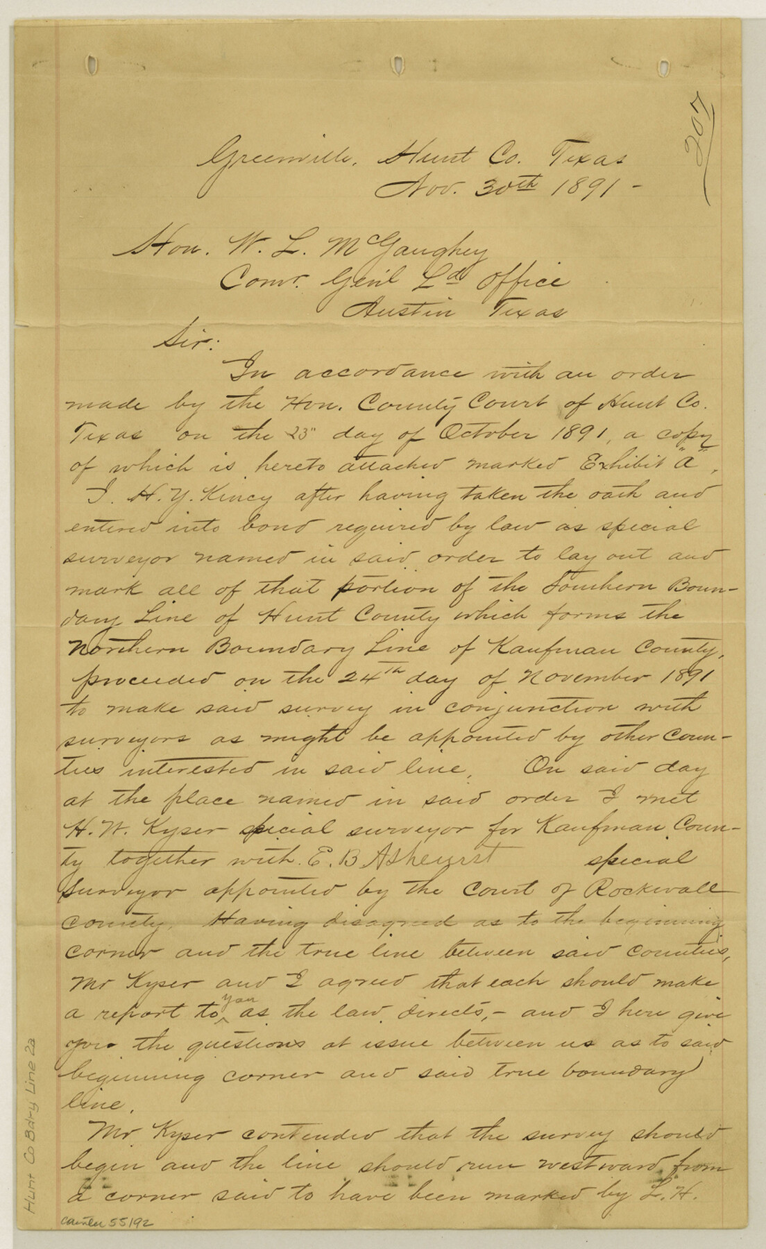
Hunt County Boundary File 2a
Certified Copy of a part of East and all the South Boundary Lines Hunt County as Surveyed Nov. 20/1846
-
Map/Doc
55192
-
Collection
General Map Collection
-
Counties
Hunt
-
Subjects
County Boundaries
-
Height x Width
14.2 x 8.7 inches
36.1 x 22.1 cm
Part of: General Map Collection
Val Verde County Sketch File 2

Print $8.00
- Digital $50.00
Val Verde County Sketch File 2
1885
Size 12.8 x 8.0 inches
Map/Doc 39169
Nueces County Rolled Sketch 58

Print $50.00
Nueces County Rolled Sketch 58
1979
Size 28.2 x 40.1 inches
Map/Doc 6899

McMullen County Working Sketch 55

Print $20.00
- Digital $50.00
McMullen County Working Sketch 55
1983
Size 15.2 x 19.2 inches
Map/Doc 70756
Coke County Sketch File 37

Print $6.00
- Digital $50.00
Coke County Sketch File 37
2004
Size 11.0 x 8.5 inches
Map/Doc 82988
No. 1 - Survey for a road from the Brazo Santiago to the Rio Grande

Print $20.00
- Digital $50.00
No. 1 - Survey for a road from the Brazo Santiago to the Rio Grande
1847
Size 18.3 x 27.1 inches
Map/Doc 72876
Dickens County Rolled Sketch C & C1

Print $35.00
- Digital $50.00
Dickens County Rolled Sketch C & C1
1895
Size 10.6 x 15.5 inches
Map/Doc 44297
Pecos County Sketch File 27A

Print $20.00
- Digital $50.00
Pecos County Sketch File 27A
Size 26.7 x 19.8 inches
Map/Doc 12166
Lynn County Rolled Sketch W

Print $20.00
- Digital $50.00
Lynn County Rolled Sketch W
Size 23.0 x 40.0 inches
Map/Doc 6655
Refugio County Working Sketch 12

Print $40.00
- Digital $50.00
Refugio County Working Sketch 12
1949
Size 42.6 x 48.2 inches
Map/Doc 63521
Crockett County Rolled Sketch 87

Print $20.00
- Digital $50.00
Crockett County Rolled Sketch 87
1967
Size 34.9 x 39.2 inches
Map/Doc 8726
Montague County Sketch File 7

Print $6.00
- Digital $50.00
Montague County Sketch File 7
1860
Size 6.3 x 5.4 inches
Map/Doc 31719
You may also like
Presidio County Working Sketch 104

Print $20.00
- Digital $50.00
Presidio County Working Sketch 104
1980
Size 39.7 x 36.0 inches
Map/Doc 71781
Duval County Boundary File 4

Print $40.00
- Digital $50.00
Duval County Boundary File 4
Size 39.5 x 13.7 inches
Map/Doc 52767
[Dallam County Map]
![93157, [Dallam County Map], Twichell Survey Records](https://historictexasmaps.com/wmedia_w700/maps/93157-1.tif.jpg)
Print $40.00
- Digital $50.00
[Dallam County Map]
Size 51.1 x 65.2 inches
Map/Doc 93157
Sabine County Sketch File 9

Print $6.00
Sabine County Sketch File 9
1912
Size 12.7 x 8.0 inches
Map/Doc 35624
Foard County Boundary File 3

Print $48.00
- Digital $50.00
Foard County Boundary File 3
Size 24.2 x 6.0 inches
Map/Doc 53516
Henderson County Rolled Sketch 11

Print $20.00
- Digital $50.00
Henderson County Rolled Sketch 11
1915
Size 28.9 x 42.5 inches
Map/Doc 75959
Baylor County Rolled Sketch 11

Print $20.00
- Digital $50.00
Baylor County Rolled Sketch 11
Size 19.4 x 19.9 inches
Map/Doc 5128
Presidio County Rolled Sketch D

Print $20.00
- Digital $50.00
Presidio County Rolled Sketch D
Size 13.7 x 22.4 inches
Map/Doc 7408
Dimmit County Sketch File 58

Print $20.00
- Digital $50.00
Dimmit County Sketch File 58
1951
Size 18.0 x 9.8 inches
Map/Doc 11361
Blanco County Boundary File 2

Print $6.00
- Digital $50.00
Blanco County Boundary File 2
Size 8.0 x 6.8 inches
Map/Doc 50540
Gaines County Sketch File 17

Print $32.00
- Digital $50.00
Gaines County Sketch File 17
1962
Size 11.3 x 8.8 inches
Map/Doc 23204
General Highway Map, Wichita County, Texas

Print $20.00
General Highway Map, Wichita County, Texas
1961
Size 18.2 x 24.6 inches
Map/Doc 79709